Diving the SAS ''Gelderland''

The dive site SAS Gelderland is a 1988 wreck in the Karbonkelberg headland area on the Atlantic seaboard of the Cape Peninsula, near Cape Town in the Western Cape province of South Africa.
Understand
edit
Position
edit- 1 SAS Gelderland wreck: S34°02.070’ E018°18.180’
About halfway between the rock known as "Die Middelmas", off the Oude Schip point to the north, and the offshore rock at Duiker point to the south.
There are two main sections of wreckage known. The central section of the hull with the engine room is at the position given, and the bow is some distance away to the south at 30 m on the reef, a short distance north of the Plan B pinnacles.
This site is in the Table Mountain National Park Marine Protected Area since 2004. A permit is required. The site is within the Karbonkelberg restricted zone.
Name
edit

.jpg)
The "SAS Gelderland" was a Ford class Seaward Defense Boat, formerly the HMS Brayford, renamed on 30th August 1954. The ship was named after the Dutch battleship that transported Paul Kruger to Europe in 1900. The SAS Gelderland, was scuttled at 10:00 on 21st December 1988, North West of Duiker Point, by demolition trials.
| Displacement | 160 | tonnes | |
| Length over all | 36 | m | |
| Beam | 6 | m | |
| Draft | 1.5 | m | |
| Engine power | 2x550 | Hp | |
| Engines | 3 | ||
| Screws | 3 | ||
| Speed | 18 | knots | |
| Endurance | ? | n. miles at ? knots | |
| Complement | 19 | ||
| Armament | Depth charge rails | ||
The "Plan B pinnacles" were the alternative option for a dive site on the first recorded occasion that anyone dived there. The name stuck. They are a pleasant dive and a bit more sheltered than many of the better known sites of the area.
"Plan C pinnacles" were picked up on echo sounder during a survey dive at "Plan B pinnacles" and surveyed a few weeks later. They are a smaller group of two pinnacles, reaching up to a minimum depth of about 20 m, on a local bottom of a bit deeper than 27 m.
Depth
editMaximum depth on the sand is 35 m, top of wreckage and nearby reef generally below 30 m
Topography
editThe vessel was about 40 m long but the main section of wreckage is now only about 20 m as the bow and stern sections were blown right off when scuttling it. The midships section lies moderately intact and upright on a narrow strip of sand at 35 m. There is a reef of huge boulders with some great reef life to the north and a pinnacle which rises to 13 m is fairly close by to the south. Unfortunately the superstructure and funnels are gone and much of the hull has filled with sand. The nearby reef to the south is low profile, not much more than a metre or so above the sand. The bow section is said to lie about 60 m to the southwest of the main wreckage, northwest of the Plan B pinnacles, at about 30 m depth. There is a stockless anchor near to the midships section on the reef, to the south, but the exact position is not known. The wreckage of the bow structure is scattered around the reef, with no large pieces.
Geology: Sand bottom in a narrow strip with outcrops of granite reef of the late Pre-Cambrian Peninsula pluton to the north and south.
Conditions
editThe site is exposed to south west and north west swell end winds, but is reasonably sheltered from south easterly winds. The site is diveable in low to moderate swell height as long as the wave period is short. The site is usually at it's best in summer but there may also be occasional opportunities in autumn and early winter.
This is an area which sometimes has upwellings, caused by the south easterly wind, resulting in cold clean water, and which may be followed by plankton blooms, which will reduce visibility again.
If the south-easter blows strongly, the trip back will be wet and uncomfortable.
Get in
editThe site can only be reached by boat. It is about 7.5 km from the slipway at Hout Bay harbour.
Do
editDive at one of the listed sites, and explore the vicinity, follow one of the routes, or explore an uncharted area and let us know what you find.
1 SAS Gelderland wreck: S34°02.070’ E018°18.180’. The midsection of the hull. It will not take very long to explore this piece of wreckage, on a clear day you can see it all at once. Take your time inspecting the visible machinery, then you can either explore the reef to the north, which is shallower, search for the missing stern, or swim along the sand edge and see where it leads you. The Pan B and Plan C pinnacles are roughly to the south, and can be reached quite easily, but you may use up your gas or time getting there.
2 Plan B pinnacle: S34°02.125’ E018°18.190’. A pretty reef, compact and high profile, but not very big. Swim around it either way, and gradually rise up the walls, and ascend from the top for maximum dive time. You can also explore a bit away from the reef. there is scattered wreckage to the north, mostly bits of structural plate, thought to be from the bow section.
3 Plan C pinnacle: S34°02.090’ E018°18.099’. Much the same dive plan applies as for Plan B, though the high reef is smaller, and there may not be wreckage. Or you may find the missing stern section. Let us know.
See
editMarine life
editThe high profile reefs to the north and south of the wreck are fairly colourful compared to the shoreline reefs of Leeugat bay, but not quite to the standard of the more exposed Star Wall reef complex to the south. As is usually the case in this region, the steeper and overhanging faces often support more diversity of invertebrates than the lower surrounding reef.
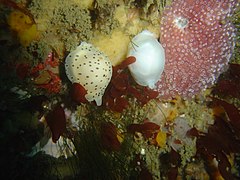 Baby toes trivia
 Tan nudibranch
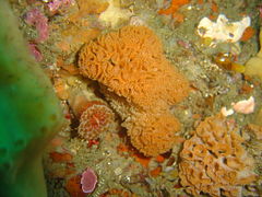 Lacy false corals


Features
editFairly recent wreckage of a small steel naval vessel.


.jpg)
.jpg)
Photography
edit(recommendations)
Routes
editNo particular routes recommended. The site is small.
Stay safe
editNearby
edit
- 1 Rachel's Reef
- 2 Wilhelm's Wall
- 3 Humpback Ridge
- 4 MV Harvest Capella
- 5 Die Middelmas
- 6 Twin Towers
- 7 MV Ker Yar Vor and the Jo May
- 8 SS Maori
- 9 SS Oakburn / MV Bos 400
- 10 Die Perd
- 11 Kanobi’s Wall
- 12 SURG Pinnacles
- 13 Star Wall
- 14 Sunfish Pinnacle
- 15 Stonehenge Dusky Pinnacles - Coral Pinnacle
- 16 Canyon
- 17 Stonehenge Blinder
Back to the Alphabetical list of sites, or list of dive sites in the Oude Schip and Leeugat area
Other regional dive sites:
- Dive sites of Table Bay and approaches
- Dive sites of the Cape Peninsula east coast
- Dive sites of False Bay offshore and approaches
- Dive sites of False Bay east coast
- Fresh water dive sites of the Cape Town Metropolitan Area