Diving at Stonehenge

The dive site area Stonehenge is an offshore rocky reef in the Karbonkelberg headland area on the Atlantic seaboard of the Cape Peninsula, near Cape Town in the Western Cape province of South Africa, south of Duiker Point. The Stonenge reef complex includes the named dive sites Stonehenge North, Stonehenge Central, Stonehenge South, Stonehenge wreck, Stonehenge Blinder, A360 Pinnacles, Canyon, and the Dusky Pinnacles reefs, which include Coral Pinnacle and Sponge Garden.
Understand
edit_map.png)
The Stonehenge reef complex is a large area with varied topography, biodiversity and depth variation. There are plenty of shallow areas suitable for entry level divers, and several pinnacles and small walls suitable for slightly more qualified divers. None of the sites are deep enough to be restricted to divers with deeper certifications, but the whole area is quite exposed to the prevailing swell and there is a lot of split-fan kelp on the reef down to about 21 m.
Position
editSouth of Duiker Point, below Karbonkelberg:
- 1 Stonehenge North: S34°02.625' E018°18.300'. These are some of the defining markers for Stonehenge, as they stick out of the water and can be seen from a distance.
- 2 Stonehenge Central: S34°02.750' E018°18.300'. A line of exposed rocks in roughly the middle of the high reef area.
- 3 Stonehenge South: S34°02.835' E018°18.365'. A half tide rock on the southern edge of the area.
This site is in the Table Mountain National Park Marine Protected Area, proclaimed in 2004. A permit is required. The site is within the Karbonkelberg restricted area.
Name
editThe area is named "Stonehenge" after a group of rocks which break the surface near a much larger rock which is shown on the charts, possibly by someone who had no idea of what the original Stonehenge megalithic structure looks like, but just liked the name.
Depth
editMaximum depth is over 30 m, along the western edge, and the depth varies considerably with the sites, some of which break the surface.
Visibility
editVisibility will vary with season and weather conditions in much the same way as other sites in this area. On a good day it should be 10 m or more, possibly as much as 20 m on an exceptional day, and should generally be more than 5 m in diveable conditions. However it is possible for a plankton bloom after an upwelling to reduce visibility, particularly near the surface, even when conditions are otherwise optimal. If this happens, visibility will usually improve with greater depth, but it may be quite dark below the bloom.
Topography
editBig boulders and rock outcrops over an extensive area. High relief in deeper areas with swim-throughs, gullies, holes and overhangs.
Stonehenge blinder is a huge granite corestone pinnacle about 65 m E-W by 45 m N-S at the base, tapering to 45 m E-W by 25 m N-S near the top. There is a narrow crack about 1.5 m wide and several metres deep by 15 or more metres long near the south east side, and the north side is very sheer. The top point is a bit away from the north eastern edge and is about 3 m deep. The bottom is lower profile reef at 20 m and deeper.
The western pinnacles are along the edge of the slope to deeper water, and the northern and eastern sites are relatively shallow. This is a huge area of reef which has not been explored very extensively and is only partly surveyed.
Geology: Granite of the late Pre-Cambrian Peninsula pluton
Conditions
editThe site is exposed to south westerly swells, so best when the south west swell component is low and short. This may occur during or after south easterly winds. The site is usually at it's best in summer, but there may also be occasional opportunities in autumn or early winter. The area to the south of Duiker point is marked on the charts as "Bakleiplaas" which is thought to be a reference to the usually relatively choppy surface conditions. The sea here is seldom really flat. The reef is not very extensively explored as conditions are not often good for diving, particularly in the shallower parts, where there is usually white water and strong surge.
This is an area which sometimes has upwellings, caused by strong south easterly winds, resulting in cold clear water, and may then have a plankton bloom after a few hours of strong sunshine, which will reduce the visibility again.
Expect cold water (about 11°C). Temperature ranges between about 8°C to 14°C
Get in
editThe site is only accessible by boat. It is about 6.5 km from Hout Bay harbour.
Do
editDive at one of the listed sites and explore the vicinity, or explore an uncharted area and let us know what you find.
North Stonehenge area
edit
1 Sponge Pinnacle: S34°02.587' E018°18.235'. This is at the east end of Sponge Garden. Maximum depth in this area is about 25 m, and the top is about 10 m. Quite pretty reef and quite colourful sponges in the deeper areas, with kelp on top of the shallower reef.
2 Dusky Pinnacles - Coral Pinnacle: S34°02.590' E018°18.206'. Dusky Pinnacles, with Coral Pinnacle and Sponge Garden lie to the north west of the exposed rocks of Stonehenge North. There are a few pinnacles grouped quite closely in a rough line from west to east.Coral pinnacle is named for the noble corals on its sides. It is a typical single huge boulder on a flat bedrock base, like several others in this region. It is small enough that most divers will move away from it at some stage of the dive, so a DSMB is recommended in case you do not get back to the shotline. Depths of 24 m are found nearby, and over 30 m is possible by swimming west or north. There is a lower pinnacle a short distance to the west and another slightly north-east. The area to the south west is not mapped or reported in any detail, but is probably also deeper than 30 m. There is a smaller pinnacle south of the Duskies which rises to about 7 m depth on top, and other roughly 9 m pinnacles a short distance to the east. These pinnacles were named after a pod of dusky dolphins which were seen at the pinnacle on the day that it was first surveyed, which was the first recorded dive at the site. It is a pretty area, but not very big. It is shallow on top, but also one of the deeper areas of Stonehenge as it is on the edge of the high reef area. If you have time to spare, head east along the north side past the row of lower pinnacles to the east, which is the Sponge Garden, and has several large swim-throughs under the pinnacles, and several overhangs and small walls, which have quite diverse and colourful sponges.
3 Stonehenge North: S34°02.625' E018°18.300'. A relatively shallow and kelpy area, marked by the exposed rocks to the north of the area. Not well known. Let us know what you find.
Southwest Stonehenge
edit4 A360 Pinnacles: S34°02.740' E018°18.200'. The A360 Pinnacles are a pair of roughly parallel ridges to the southwest of Stonehenge Central, at the edge of the 24 m contour, with a 27 m gully between them. The south ridge rises to 10 m and the north ridge to 15 m on top. This is a nice site in good visibility, and is deep enough to avoid much of the surge. The kelp thins out by 24 m. The southern ridge is split transversely by several cracks, the north is more monolithic and has a nice little wall on the south side. To the west the bottom is relatively flat, undulating bedrock at about 21 m, with boulders and a lot of kelp.
Central Stonehenge
edit5 Stonehenge Central: S34°02.750' E018°18.300'. Stonehenge Central is relatively shallow and heavily grown with kelp. A large, little explored area of large boulders, some of which extend above the surface, marked by a line of granite boulders sticking up out of the water. Not very deep, and seldom calm enough to look like a pleasant dive. Although shallow, it is high profile reef with lots of small gaps and overhangs.
South Stonehenge
edit6 Stonehenge South: S34°02.835' E018°18.365'. A large, flattish, half-tide rock, with a large number of sandy anemones. A shallow area, mostly above 15 m and the top of the rock above 6 m is quite large, and very surgey.
7 Stonehenge Wreck: S34°02.885' E018°18.335'. Drop a shotline at the GPS position and use it to find the wreckage, which is a small amount of debris at 21 m from a small workboat which sank here while transporting salvaged steel from the wreck of the Bos 400 towards Hout Bay harbour. After looking at this, swim a compass course to the blinder, which is the most interesting recorded topographical feature in easy reach, or do your own thing and explore the area. Carry a DSMB and use it to alert the boat when you start ascent.
8 Stonehenge Blinder: S34°02.838' E018°18.316'. A large boulder or outcrop, rising from about 24 m to the south to about 3 m on top, where the surge can be very strong. Drop in at the pinnacle and descend to the bottom. Slowly ascend as you swim around the pinnacle, observing the various ecological zones. If the sea is calm, a safety stop can be done over the top of the pinnacle, otherwise deploy a DSMB or ascend on the shotline.
See
editMarine life
editTypical of the big reefs of the Atlantic coast. There is a heavy growth of red bait in shallow areas, Kelp on top surfaces in moderate depths, and fairly bare rock with urchins on relatively flat deep surfaces. Walls, overhangs and other steep surfaces are covered with wide variety of sponges, corals, ascidians and other invertebrates.
 Anemones, whelks and mussels
 Colonial ascidian and brittle stars
 Anemones and mussels
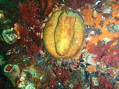 Red bait pod
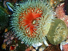 Sandy anemone
 Dense cover of sandy anemones
 Anemones and sponges
 Dense cover of striped anemones
 Sponges and colonial ascidians
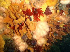 Sponges and soft corals
 Noble coral
 Soft corals, rock lobster, sponges and colonial ascidians


Photography
editGood photographic site. There will always be good subjects for macro work, and wide angle with natural lighting will produce good results on a clear day.
Stay safe
editHazards
editCold water, Strong surge in gulleys and swim-throughs, and over the top of the shallow parts of the reef. Strong offshore winds may develop over a short time.
Skills
editNo special skills required. The ability to deploy a DSM and use a compass is useful.
Equipment
editA light can be useful to look into dark places and to restore colour at depth. A compass can help keep track of your position, and a DSMB is handy to allow the boat to keep track of ascending divers. Nitrox can extend your no-decompression time if you are well insulated.
Nearby
edit
- 1 MV Ker Yar Vor and the Jo May
- 2 SS Maori
- 3 SAS Gelderland
- 4 SS Oakburn / MV Bos 400
- 5 Die Perd
- 6 Kanobi’s Wall
- 7 SURG Pinnacles
- 8 Star Wall
- 9 Sunfish Pinnacle
- 10 Canyon
- 11 Seal Island
Back to the Alphabetical list of sites, or list of dive sites in the Outer Hout Bay area
Other regional dive sites:
- Dive sites of Table Bay and approaches
- Dive sites of the Cape Peninsula east coast
- Dive sites of False Bay offshore and approaches
- Dive sites of False Bay east coast
- Fresh water dive sites of the Cape Town Metropolitan Area