Diving at Canyon

The dive site Canyon or Duiker Point Canyon is an offshore rocky reef in the Duiker Point area on the Cape Peninsula, near Cape Town in the Western Cape Province of South Africa.
Understand
edit
Canyon is a relatively deep site first named in 2013, and may be diveable when the other sites nearby have too much surge. Reports from divers suggest that the site has spectacular topography, and good biodiversity.
Position
editName
editThe name "Canyon" refers to the wide gully north of the row of pinnacles reported at the site.
Depth
editMaximum depth is about 35 m. and the top of the pinnacle is about 19 m. (Average depth is likely to be about 27 m.)
Visibility
editVisibility will vary with season and weather conditions in much the same way as other sites in this area. On a good day it should be 10 m or more, possibly as much as 20 m on an exceptional day, and should generally be more than 5 m in diveable conditions. However it is possible for a plankton bloom after an upwelling to reduce visibility, particularly near the surface, even when conditions are otherwise optimal.
Topography
editThis site has not yet been extensively surveyed, but several pinnacles and a few small caverns have been found.
Canyon pinnacle is a large group of huge boulders and outcrops rising from more than 32 m to about 19 m on top There are deep crevices and overhangs, and lots of near vertical surfaces, so this is a topographically spectacular area in good visibility, and very colourful, with heavy growth of sponges and cnidarians on the steep and overhanging faces, and scattered split-fan kelp and other seaweeds on the upper surfaces.
Geology: Granite of the late Pre-Cambrian Peninsula pluton
Conditions
editSurge — The site is exposed to south westerly swells, but due to the depth, surge should not usually be a problem unless the swells have a rather long period.
Currents — At times there may be a slight current.
Temperature — The water will usually be cold. Temperatures are generally 12°C or less, but have not been recorded lower than 8°C. 14°C would be considered unusually warm. A thermocline of one or two degrees may occur, and this is often associated with a change in visibility.
Seasonal variations — Conditions suitable for diving this site will be most common in summer, but any time when the south westerly swell is weak and low may be suitable, though visibility may be more unpredictable in winter.
Upwellings and plankton blooms — This is an area which sometimes has upwellings, caused by the south easterly wind, which generally bring in cold, clear, nutrient rich bottom water. This will usually develop a plankton bloom over a day or two of good sunshine, which will reduce shallow water visibility again. This means that the best times to dive are during or directly after an extended period of moderate to strong south easterly winds, and this generally happens in summer. A plankton bloom which reduces surface visibility to 2 to 5 m may well only extend down a moderate distance, and the visibility below will usually be better. The depth of the bloom is unpredictable and may range from around 5 or 6 m to about 20 m. Light levels below the bloom are often drastically reduced, and the colour tends to be very green.
Adverse weather — Moderate to strong winds with a significant westerly component, or large swells or wind waves from the north west to the south west are likely to produce unsafe or unpleasant conditions, and should be avoided.
Get in
editThe site can only be accessed by boat. It is about 6.6 km from the slipway at Hout Bay harbour. The ride will usually take 10 to 20 minutes, depending on the weather. It there is a strong south easter, the ride back will be relatively wet and bumpy. It is usual to fully dress in your wet or dry suit before leaving the harbour, though gloves and hoods may be left until you reach the site. Completion of kitting up and pre-dive checks are done on site.
See
editMarine life
edit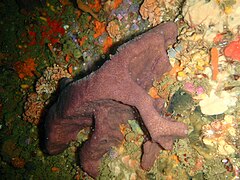 Brown sponge
 Orange fan sponge
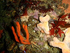 Orange tree sponge
 Brooding cushion star
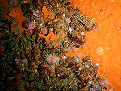 Mussels


Photography
editSuggested Routes
editUntil the site is known better, most dives will probably start at the 19 m pinnacle, so take a look at the caverns under the pinnacle, and explore the general area.
Stay safe
editHazards
editNo site-specific hazards known.
Skills
editMost boat operators will probably insist on certification for at least 30 m. Ability to deploy a DSMB from mid-water is strongly recommended.
Equipment
editA DSMB is useful if you surface away from the shot line or there is no shot line. Nitrox can significantly extend your dive time if you are well insulated, and a dry suit is recommended as the water will be cold. If you have a full face mask, it will help on the really cold days, but most divers just allow a few minutes for their face to get used to the cold.
A dive light is worth taking along, as if the surface water is turbid or the lighting is just gloomy due to depth, it may be fairly dark in the deeper areas, and artificial lighting will bring out the bright reds, oranges and yellows of the invertebrates on the vertical and overhanging faces of the rocks. A wide angle light beam is best, as it allows close up examination of the organisms while illuminating enough of the surface that you don't have a tiny hot spot on a generally dim background.
Nearby
edit
- 1 Die Middelmas
- 2 Twin Towers
- 3 MV Ker Yar Vor and the Jo May
- 4 SS Maori
- 5 SAS Gelderland
- 6 SS Oakburn / MV Bos 400
- 7 Die Perd
- 8 Kanobi’s Wall
- 9 SURG Pinnacles
- 10 Star Wall
- 11 Sunfish Pinnacle
- 12 Stonehenge Dusky Pinnacles - Coral Pinnacle
- 13 Stonehenge Blinder
Back to the Alphabetical list of sites, or list of dive sites in the Outer Hout Bay area
Other regional dive sites:
- Dive sites of Table Bay and approaches
- Dive sites of the Cape Peninsula east coast
- Dive sites of False Bay offshore and approaches
- Dive sites of False Bay east coast
- Fresh water dive sites of the Cape Town Metropolitan Area