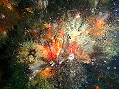
The dive site Ammunition Barges is two inshore recent wrecks in the Seaforth area on the False Bay coast of the Cape Peninsula, near Cape Town in the Western Cape province of South Africa.
Understand
edit
This is a shallow site and the wrecks have partly collapsed but there is still recognisable structure.
Position
edit- 1 Ammo barges: S34°11.408’ E018°26.985’
Bearings:
- 317° magnetic to the first corner of the harbour wall (from the shore)
- 268° magnetic to the Martello Tower
- 250° magnetic to the near corner of the IMT building
- 222° magnetic from Nimrod Rock (submerged, unlikely to break in diveable conditions)
- 146° magnetic to Noah's Ark
About 100m east of Phoenix shoal About 500m from the beach at IMT
This site is in a Marine Protected Area (2004). A permit is required. The site is entirely inside the Boulders Restricted Zone.
Name
editThe name "Ammunition Barges" is a description of the two small wrecks that make up the dive site.
Depth
editMaximum depth is about 10 m. and the top of the wreckage is about 8 m. Average depth is likely to be about 9m.
Visibility
editVisibility is usually not very good in this area. Expect 3 to 6 m on a good day, though it can be better or worse.
Topography
editThe bottom in this area is flat sand with a few low flat outcrops of granite reef. There are two small (about 20 m long) barge wrecks right next to each other at one end, and diverging at a small angle. The wrecks are steel, and have largely broken up. There are some sections of hull side plating and frames still standing, but the ends have collapsed.
Geology: Sand and occasional low outcrops of Pre-Cambrian granite of the Peninsula pluton.
Conditions
editA shallow dive, in a reasonably protected area from south west swell, but quite exposed to the north-wester, which may raise a bit of a chop and make it difficult to find the wreck, though unlikely to cause much surge. The north-wester can cause a current that sets east.
The site is moderately exposed to wind and waves from the south east, Which will usually reduce visibility.
The site is usually at it's best in winter but there are also occasional opportunities in other seasons
Facilities
editParking is adequate and tarred (since the aerial photo). The parking area is used by tour buses, use the smaller marked bays.
Get in
editUsual access is by boat from Miller's Point slipway or Simon's Town jetty, but can be dived from the shore entry at Seaforth (Boulders Beach).
Shore Dive: Turn off the main road at the IMT sign. Park behind the IMT building. Walk through the gate to the right of the IMT main gates and over the dunes to the beach. The water is shallow to the left near the building and there is some dense kelp around the boulders.
It is about a 500 m swim on a bearing of roughly 071° magnetic from the corner of the beach nearest IMT. There are patches of heavy kelp on the inshore reef, and several rocks which either reach the surface or near enough to obstruct a diver, so this will not be a good underwater swim on a fixed bearing. If you can see white water at Nimrod rock you can try swimming out to it, then diving and swimming about 130 m on bearing 138° magnetic, but there are other rocks at Phoenix shoal which may also break.
The most likely way to find the wrecks from a shore dive is to swim out on the surface and get a fix from the bearings given in the position section. Use at least three, preferably all. to compensate for errors.
The bottom is mostly sand, so once you are roughly in position, the wrecks may be visible from the surface as a dark patch.
See
editMarine life
editLots of Red chested cucumbers and Stephens' codium.
- Various sea cucumbers
- White edged nudibranchs
- Sponges at the ammunition barge
- Red sea cucumbers and a sea squirt at the ammunition barge
Features
editPhotography
editWide angle lens using ambient light may capture the mood of the site. Otherwise macro photography of the somewhat limited range of marine life.
Routes
editThe site is shallow and compact. you can explore it all on one dive.
Stay safe
editNearby
editBack to the Alphabetical list of sites, or list of dive sites in the Seaforth to Froggy Pond area
Other regional dive sites:
- Dive sites of Table Bay and approaches,
- Dive sites of the Cape Peninsula west coast
- Dive sites of False Bay offshore and approaches
- Dive sites of False Bay east coast
- Fresh water dive sites of the Cape Town Metropolitan Area


