Diving at Maidstone Reef

The dive sites Maidstone Rock, Maidstone Reef and Ammo Reef are offshore rocky reefs in the Seaforth area of Simon's Town on the False Bay coast of the Cape Peninsula, near Cape Town in the Western Cape province of South Africa.
Understand
edit
Position
edit1 Maidstone Rock: S34°11.577' E018°27.474'. The high pinnacles, and nominal position for the area. These reefs are to the east of Noah's Ark
This area is entirely inside the Boulders Restricted Zone of the Table Mountain National Park Marine Protected Area, proclaimed in 2004. A permit is required.
Name
edit"Maidstone Rock"is the name given the to the group of high pinnacles of the reef on the SA Navy charts. The deeper but more extensive reef to the east is known as Maidstone Reef or Anchor Reef, and the scattered outcrops around the two are generally referred to as the Maidstone Rocks. Ammo Reef is the compact reef further to the east. Several large naval gun shells have been seen on this reef.
Depth
editThe sand bottom slopes gradually down to the east. Maximum depth is about 21 m on the sand at Maidstone Rock, and the top of the highest pinnacle is about 7 m deep at low tide. Anchor Reef is about 24 m on the sand, and the highest point is about 14 m deep. Ammo Reef is about 17 m on top, and the surrounding sand is about 27 to 28, possibly 30 m deep.
Topography
editThe reefs include a cluster of granite pinnacles of various heights on a flat fine sand bottom, and a large contiguous section of reef of about 226 m east to west by 113 m north to south, rising about 15 m from the sand at the highest point, but mostly somewhat lower. About 100 m further east across the sand bottom, a substantial outcrop known as Ammo reef rises from 27 m on the sand to 17 m on top, with several parallel cracks running roughly east-west.
Geology: Late Pre-Cambrian granite from the Peninsula pluton. Some of the pinnacles of the Maidstone Rock group have the characteristic rounded edges and corners of corestones, and the rounded undercuts in the tall pinnacles suggest that they were originally weathered underground. The Anchor Reef and Ammo Reef outcrops have the typical rounded shape of corestones, and there is a large amount of relatively small boulder-rubble along the southern perimeter of Maidstone reef.
Conditions
editThe site is exposed to wind and waves from the south east, so should be dived in westerly winds or a calm. The fetch is long enough for a north-westerly wind to develop a lumpy chop, but not long enough for this chop to reach down to the reef, though the ride may be wet and bumpy.
The site is reasonably protected from south westerly swells, but long period swells from the south west will cause strong surge, and may reduce visibility
The site should usually be at its best in winter but there may also be occasional opportunities at other times of the year.
Get in
editAccess to this site is by boat, It is about 4.4 km from the Miller's Point slipway to Maidstone Rock, and much the same to Anchor and Ammo Reefs.
Alternative boat access from the Simon's Town jetty is closer, at about 3.4 km to Maidstone Rock and 3.8 km to Ammo Reef.
Do
editDive at one of the listed drop points and explore the vicinity.
1 Maidstone Rock: S34°11.577' E018°27.474'. This is the highest of a cluster of very precipitous granite pinnacles on fairly flat sand bottom. The site is spectacular in good visibility. The main cluster is quite closely spaced, with the pinnacle ridges running more or less north east to south west, and gaps of a few metres wide between them. There are probably more pinnacles to the east and to the north west that have not yet been surveyed. A couple of the pinnacles have deep rounded undercuts part way up the sides, but not quite enough to trap air. No particular routes are known. Work your way along the line of pinnacles as suits you best. The high pinnacles are clustered together and this is the most spectacular part of the reef, both for topography and diversity of life. Maximum depth is about 21 m on the sand, and the top of the highest pinnacle is about 7 m deep at low tide.
2 Anchor Reef: S34°11.575' E018°27.600', or Maidstone Reef, is a large, fairly flat topped area of bedrock that extends a few metres above the sand. Sand bottom at the edge of reef ranges from about 21 m to 24 m near the rock, but to the north the sand slopes down visibly past a few outliers and reaches 26 m quite nearby, at which stage it has flattened out. The central north side seems to have more rugged topography, with a steep drop-off from above 18 m to the sand. The profile is steep and high along the north side, but flatter in most places, and there are a large number of small boulders scattered along the slopes to the south. There is a large anchor lying on the reef just below 18 m to the south, and this section of reef is named for the anchor. There are two areas of interest: The old anchor, and the north face. The anchor is relatively small and difficult to find, so start there. When you have seen enough, swim roughly northeast and you will get to the highest point. Further north the reef drops down to the sand quite rapidly, and there are a few scattered outcrops on the sand slope. The wall of the north face is steep and quite complex, so it will have the highest biodiversity. To the east of the 21 m contour there is a pair of curved steel beams which could be the remains of a boat davit. Maximum depth is about 24 m on the sand, and the highest point is about 14 m deep.
3 Ammo Reef: S34°11.564' E018°27.754', to the east of Maidstone reef, is a fairly monolithic outcrop with a marked groove along the length of top, and parallel jointing to the north east. The top of reef is about 17 m deep, and the sand bottom at about 27 m to the east. The topography is not particularly rugged, and most of the reef edge slopes fairly gently down to the sand. A few fairly large bore naval shells have been seen on the reef top. They appear to be about 125 mm diameter, but are quite heavily encrusted. This is a compact reef, and you can visit most of it on a single dive. There is not a lot of variation in topography in different directions, so go where it pleases you. The shells are quite small and not particularly interesting, so not worth a search. Start deep and work your way up is as good a plan as any.
See
editMarine life
editMaidstone Rock
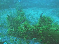
Typical of the outer reefs in this area, but not many sea fans. Different rocks have different characters with different dominant invertebrates. Mauve sea cucumbers, striped anemones, strawberry anemones, black brittle stars and common feather stars are abundant. Large numbers of large whelks with egg masses have been seen. Fish may include Roman and small shoals of Hottentot.
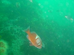 Reef scene at Maidstone Rock
 Klipfish
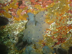 The colonial ascidian "Blue Choirboys"
 Small Abalone
 Spider crab on Mauve sea cucumbers


Anchor Reef
 Large iron anchor, possibly from a RN ship of the early 19th century
 Teat sponge with common feather stars
 Echnoderms, sponges and hydroids on the reef


Ammo Reef
Features
editThere is a large iron Royal Navy style anchor about 6 m long, 4 m wide on top of Maidstone Reef just below the 18 m contour to the south. The anchor has lost its stock and one fluke is broken, but still with the anchor. The crown is a slightly pointed curve, the flukes large and triangular, each about a metre long. The shank is about 6 m long, lying roughly horizontal about half a metre above the reef. The ring is large, about 600 mm diameter, suitable for use with thick natural fibre cable. There is no sign of a hole in the shank for an iron stock, so it may have had a wooden stock, as was common on older anchors of this type.
Photography
editMacro or wide angle lenses are most suited to the site and the visibility to be expected.
Stay safe
editHazards
editNo site specific hazards are known.
Skills
editNo special skills required. Ability to deploy a DSMB recommended.
The depth is a bit much for entry level divers restricted to 18 m, and although much of the Maidstone Rocks pinnacles is above 18 m, the walls are near vertical, and the bottom is consistently deeper than 18 m, so good buoyancy control is needed to stay above 18 m, and good buoyancy control is not common in entry level divers.
Equipment
editNo special equipment required. A DSMB is recommended to inform the boat of where you will be surfacing.
Nearby
edit
- 1 Noah’s Ark Rock
- 2 Torch Reef
- 3 Outer Photographer's Reef
- 4 Photographer’s Reef
- 5 Penguin Point
- 6 Dangerous Doug Reef
- 7 Windmill Offshore
Back to the Alphabetical list of sites, or list of dive sites in the Seaforth to Froggy Pond area
Other regional dive sites:
- Dive sites of Table Bay and approaches,
- Dive sites of the Cape Peninsula west coast
- Dive sites of False Bay offshore and approaches
- Dive sites of False Bay east coast
- Fresh water dive sites of the Cape Town Metropolitan Area