Diving the Cape Peninsula and False Bay/Windmill Offshore Reefs

The dive sites at Windmill Offshore Reefs are a group of offshore rocky reefs in the Seaforth area of False Bay, near Cape Town in the Western Cape province of South Africa.
Understand
edit

These are several scattered groups of granite outcrops between about 400 m and 1.5 km offshore of the well-known shore entry site at Windmill Beach. These offshore reefs are seldom dived and little known. Some may never have been dived. Most have not yet been surveyed, and do not feature on the official navy hydrographic charts. The approximate positions without any depth detail were taken from a sidescan sonar survey by the Council for Geoscience, and they are gradually being explored and mapped. Those which have been partly surveyed are Outer Windmill, Dangerous Doug Reef, Windmill Offshore, Lace Reef and the Three Bears Pinnacle. SUEX Reef was first visited on a shore dive with scooters from Windmill Beach East Cove. The position was estimated by dead reckoning and allocated to the most likely looking reef in the area. The reef identity is yet to be confirmed by GPS, or surveyed.
Position
edit1 Windmill Offshore: S34°12.050' E18°27,800' Chosen as the nominal position for this group of dive sites as the reef section more or less in the middle.
This area is in the Table Mountain National Park Marine Protected Area, proclaimed in 2004. A permit is required. Some of the sites are inside the Boulders Restricted Zone.
Name
editWindmill Offshore Reefs describes the geographical location offshore of the local landmark, Windmill Beach, as do the names Outer Windmill and Windmill Offshore. If there ever was a windmill, it is lost to memory.
Depth
editDepth of the sand bottom increases gradually with distance from the shore, from about 12 m to about 30 over several hundred metres. The height of the reef above the sand varies, with no apparent pattern, and has a maximum of about 9 m off the sand.
Topography
editThe reefs are likely to be all granite corestone outcrops with occasional boulders. The reefs vary considerably from clusters of moderately sized outcrops to massive lumps of rock, much like other reefs of the area.
Geology: Precambrian granite of the Peninsula pluton, surrounded by fine quartz sand and patches of shelly sand and gravel.
Conditions
editThe sites are usually at their best in winter, during or after moderate westerly winds, and when the swell is low, but there are also occasional opportunities in other seasons.
Get in
editUsual access is by boat from Simon's Town or Miller's Point. It would be possible for a fit diver to do some of these reefs as shore dives from Windmill Beach, but the route is across the path of small craft and there would be a risk of being run down while at the surface. One of the reefs was first visited from the shore by scooter (diver propulsion vehicle), but navigation might be tricky.
The site is about 3.4 km from the Miller's Point slipway, or 4.3 km from Simon's Town jetty
Do
editDive at one of the listed drop points, and explore the vicinity, or find an unsurveyed reef and let us know what you find.
1 Three Bears Pinnacle: S34°11.887' E18°27,788'. Three Bears Pinnacle has three outcrops; one large, one small, and one in between in a tight little clump, and is named for the children's story. One is a tall, almost vertical sided pinnacle rising from the sand at 27 m to peak at 17.5 m, with a narrow crack separating it from the lower pinnacle which is about 22 m on top, and the third outcrop which is even lower.
2 Dangerous Doug Reef: S34°11.950' E18°27,650'. Medium profile granite reef with occasional areas of higher and lower profile. Eastern part includes large area of fairly level lower profile reef-top. West end is a cluster of relatively high outcrops with sandy bottomed gullies between them. There are a few low outliers to the northeast, and a group of outcrops to the north known as Dangerous Doug North Reef. Named for a local diver who did a shore dive to Photographer's Reef, and for the return swim, made the error of using the same course he had used to get to the reef, eventually surfacing quite far out to sea, possibly in the general vicinity of this reef, and was picked up by a passing boat. The high point is at about 12 m, towards the northwest, and maximum depth is somewhere in the vicinity of 20 m, at the sand edge to the east of the reef
3 Lace Reef: S34°11.960' E18°28,125' The highest point of the reef is at about 23 m. Reef-top is mostly quite flat, and some areas very flat. The reef sand edge slopes down from about 27 m to 32 m. Most of the reef edge is fairly steep, with a 3 to 5 m drop, but there are some flat areas with a little bit of broken reef. There is a large area of exposed granite bedrock, fairly flat on top, and several long straight gullies with sand bottom. Named for the large numbers of lacy false corals (bryozoans) seen at the reef.
4 Windmill Offshore: S34°12.050' E18°27,800'. Maximum depth recorded about 27 m on sand, top of reef about 18 m. Granite outcrop with deep sandy bottomed gullies and indentations and a few high points. A couple of small outliers to the northwest.
5 Outer Windmill: S34°12.090' E18°27,610'. Sand bottom is at about 12 m, and top of the reef at about 6.5 m. Not much relief.
6 SUEX Reef: S34°12.140' E18°27,885'. (estimated, possibly E18°27,800'). A long, narrow pair of straight parallel ridges with a narrow strip of sand between them. Not very high, but with a couple of higher boulders or outcrops. Fairly unmistakable appearance. Position unconfirmed but almost certainly one of the reefs labeled. Top of reef at about 14 m, sand at about 21 m. SUEX reef was named by Justin Creasey who reported it after a long scooter dive in mid 2019. The position was calculated by dead reckoning, and two groups of rocks on the sidescan survey match the estimated position well enough to be possible.
See
editMarine life
editDangerous Doug reef:
 Pink lady whelk and serpent skinned brittlestars on the sand
 Marginella
 Purple sea pen
 Flagellar sea fan
 Mauve and red-chested sea cucumbers
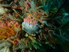 Dendrodoris caesia
 Palmate sea fan


Lace Reef:
Notable for the large numbers of pristine lacy false corals (Retoporella lata?), for which the reef was named. Numerous juvenile puffadder shy sharks have been seen, and there is heavy cover of hairy brittle stars in places on top of the reef. Mauve sea cucumbers are common, and a few varieties of sponge, palmate and sinuous sea fans. Sea spiders (pycnogonids) and spider crabs have also been seen,
 Puffadder shy shark at Lace Reef
 Red sponge
 Lacy false corals (bryozoans)
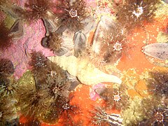 Long siphoned whelk
 Elegant feather star


Windmill Offshore:
 Cape sea urchins
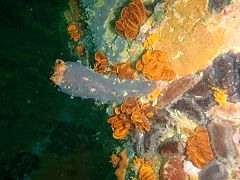 Angular ascidian
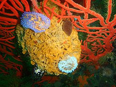 Gas flame nudibranchs
 Gas flame nudibranch
 Red fanworm


Three Bears Pinnacle:
A compact and rather small reef, which feels a little crowded with more than 6 divers, as it is only about 20 m in diameter. At the time of survey there were a few small sea fans, and the dominant group was echinoderms. Lots of mauve sea cucumbers, elegant feather stars and fragile brittlestars.
 Purple sea pen
 Sinuous sea fan
 Striped anemones
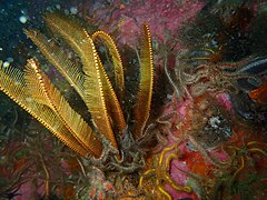 Elegant feather star
 Mauve sea cucumbers and a blenny


Photography
editSuggested routes
editThe sites are not well known and there are no recommended routes.
Stay safe
editHazards
editThe area is crossed by small boat traffic from the False Bay Yacht Club at Simon's Town, and from the town jetty.
Skills
editNo special skills are required, other than those appropriate to the depth of the dive, Several of the sites are in the depth range appropriate for entry level divers, and the rest are within the normal recreational diving depth range.
Equipment
editA DSMB is recommended if you are likely to surface away from the shotline, as a way for the boat crew to find you, and for other boats to be warned of your presence at or just below the surface.
Nearby
edit
- 1 Ammo Reef
- 2 Noah’s Ark - Heat exchanger
- 3 Anchor Reef
- 4 Maidstone Rock
- 5 Ark Rock Boiler wreck#3b
- 6 Noah’s Ark - Double row of concrete pillars
- 7 Ark Rock Barge wreck
- 8 Noah’s Ark - Single row of concrete pillars
- 9 Ark Rock Boiler wreck #2
- Ark Rock Boiler wreck #3a
- 10 Torch Reef
- 11 Outer Photographer's Reef
- 12 Photographer’s Reef
- 13 Penguin Point
- 14 Windmill Beach
- 15 Froggy pond
- 16 Fisherman's Beach
Back to the Alphabetical list of sites, or list of dive sites in the Seaforth to Froggy Pond area
Other regional dive sites:
- Dive sites of Table Bay and approaches,
- Dive sites of the Cape Peninsula west coast
- Dive sites of False Bay offshore and approaches
- Dive sites of False Bay east coast
- Fresh water dive sites of the Cape Town Metropolitan Area