Diving at D-frame

The dive site D-Frame, Oatlands Deep Reef or Wave Rock is an offshore rocky reef in the Oatlands Point area of Simon's Town on the False Bay shore of the Cape Peninsula, near Cape Town in the Western Cape province of South Africa.
Understand
edit
This is a pleasant reef, not dived very frequently. It is also the point on the west side of False Bay where the 30 m contour is closest to the shore. Divers wishing to do a 30 m shore dive can do it here.
Position
edit
Name
edit"D-Frame" is a contraction of Deep A-Frame, "Oatlands Deep" is a simple descriptive name based on the nearby Oatlands Point, and "Wave Rock" refers to a rock formation at the reef which looks a bit like a breaking wave.
Depth
editMax depth is 30 m (over the sand just beyond the end of the reef). Bottom depth on the sand is about 15 to 20 m at most parts of the reefs, and is mostly about 10 m over the sand on the way back on a shore entry dive.
Topography
editThe reef comprises several ridges of rock running about 300° magnetic with sand bottom between them. There is one point that rises to about 4 m from the surface with almost vertical drop to 14 m on both sides. Most outcrops not nearly this high. The south reef has an overhanging rock outcrop known as the “Wave Rock”.
The bottom is flat sand sloping down very gradually from about 5 m near the entry at A-Frame to almost level at about 10 m depth for a long way, then down to about 13 m at the inshore edge of the reefs. The sand slopes more steeply over the reef zone and is significantly deeper on seaward side. There are areas of sand with wave induced ridges, places where there are black mussel beds and places of coarser gravel, but the general tendency is very flat. The slope is not discernible between shore and reef, though on the seaward side of the reef it is visibly steeper. The reefs are big granite outcrops as is usual in the area, mostly rounded, and with occasional cracks and gullies, except Wave Rock which has a notable overhang. There are several similar isolated outcrops north and south of Oatlands point, extending at least as far north as Ark Rock and south to Partridge Point. Most of them are virtually unknown to divers and are not yet mapped. Some can be identified from the SA Navy chart.
Geology: Granite outcrops of the late Pre-Cambrian Peninsula pluton, surrounded by sand.
Conditions
editThe site is far enough offshore to be exposed to wind from all directions, which can produce an unpleasant choppy sea, and make it difficult for the boat crew to see a diver on the surface. However it is moderately protected from south westerly swell. It is fairly deep so will not be greatly affected by surge unless the swell is long, but may be quite dark because of the depth. The site is usually at its best in winter but there are also occasional opportunities during the rest of the year. Poor visibility at the surface does not necessarily extend to the bottom. Be aware that for a shore dive the long swim back may be a problem in an offshore wind. For this reason it is recommended that the return is done underwater. The appropriate Nitrox mix allows this to be done at the bottom as a no decompression dive. If you have gas for a 2 hour dive it can be done from the shore with both trips under water.
Get in
editBoat dive from Miller's Point slipway or Simon's Town jetty, or Shore dive from A-Frame for those who don’t mind a long swim, are competent at navigation, and want a 30 m shore dive.
For a shore dive the entry point is at "Slippery Rock" at A-Frame
See
editMarine life
editThe sand bottom in the area is fairly fine and feathery sea pens and purple sea pens may be found. Puffadder shy sharks and sand stars are fairly common. Around and beyond the reefs the sand is coarser and in places covered by clumps of common feather stars and hydroids. A considerable number of purple sea pens and cerianthids can be found between the reefs in the 20 m depth range. The North reef is covered by vast numbers of Mauve sea cucumbers, with scattered Red chested sea cucumbers and feather stars. Large shoals of Hottentot and several species of nudibranch have also been seen here. The deeper south reefs are covered mainly by Common feather stars, with areas of Mauve sea cucumbers, Striped anemones, and scattered Red bait. There are also other ascidians, sea fans and sponges. Horsefish are sometimes seen in the cracks. Barred fingerfins are often seen on the deeper reefs. A large variety of fish can be seen on a good day. Close encounters with Southern Right whales have taken place in this area.
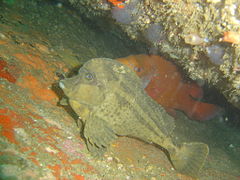 Horsefish are sometimes found in the cracks between the rocks
 The four colour nudibranch is surprisingly well camouflaged
 Tube anemone with spider crab
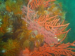 Reef scene at D-Frame
 Whelk eggs
 Large striped anemone


Features
editThere is an interesting rock overhang known as "Wave Rock", and the shortest distance from the shore to the 30 m/100 ft contour.
Photography
editGood site for invertebrate photography. Close up and Macro lenses and wide angle lenses will work well for most photographers. External flash is recommended.
Routes
editIf you go by boat, find the reef with an echo sounder or GPS, and explore as you see fit. For shore dives a few possibilities are suggested:
- South Reef (Wave Rock): Entry at slippery rock, out on 067°True (091° magnetic) from the beacon about 525 m on surface, dive to bottom and swim to the 15 m contour, follow this to the reef. Leave with enough gas for a 30 minute swim back along the bottom on 270° magnetic. If you want a 30 m shore dive, the 30 m contour is quite close to the South reef.
- North Reef: Entry at slippery rock, swim out on 048°True (072° magnetic) from the beacon about 460 m on surface, dive to the bottom and swim to the 15 m contour, follow this to the reef. Leave with enough gas for a 30 minute swim back along the bottom on 252° magnetic.
- Deep Reef: From Wave Rock swim about 200 m on bearing 085° magnetic to the large rock outcrop which ends at about 29 m depth at the South Eastern end. 30 m is a short swim from the reef, and after reaching the 30 m contour, the dive can be continued along the top of the reef until the water is a bit shallower to conserve air and bottom time. Plan on gas for at least an hour at average depth 12 m if you want to get back under water. Course 270° magnetic for 730 m will get you back to the slippery rock.
Stay safe
editHazards
editNo site specific hazards have been reported. Offshore wind may increase in strength significantly during the dive.
Skills
editNo special skills are required for boat dives, though appropriate certification for the planned depth is expected. The ability to deploy a DSMB is useful to let the boat know where you are surfacing. Shore divers need to be fit and competent at compass navigation, and should choose weather conditions which will allow a return on the surface if necessary.
Equipment
editA light helps restore colour lost due to depth. A compass is essential for shore dives, both to find the site and navigate back to the exit point. A SMB or DSMB is recommended as this is an area with a fair amount of boat traffic. Nitrox is particularly useful for shore dives, as it can allow a no stop dive with the trip out and back at the bottom, which is more interesting than the long surface swim otherwise necessary.
Nearby
edit
- 1 Windmill Offshore
- 2 Windmill Beach
- 3 Outer Windmill
- 4 Froggy pond
- 5 Fisherman's Beach
- 6 A-Frame
- 7 Insanity Reef
Back to the Alphabetical list of sites, or list of dive sites in the Oatlands Point area
Other regional dive sites:
- Dive sites of Table Bay and approaches,
- Dive sites of the Cape Peninsula west coast
- Dive sites of False Bay offshore and approaches
- Dive sites of False Bay east coast
- Fresh water dive sites of the Cape Town Metropolitan Area