Port Huron
.jpg)
city in Michigan, United States
Port Huron is a city in Southeast Michigan, the second-busiest border crossing (with Sarnia, Ontario) in the state.
Get in
edit
Map of Port Huron
By car
edit- From the south take Interstate 94 east
- From the west take Interstate 69 east
- 1 Blue Water Bridge. From Ontario take Highway 402 west crossing the St. Clair River into the United States via the Blue Water Bridge


By train
edit- See also: Rail travel in the United States
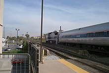
The Detroit Amtrak station

- 2 Port Huron station, 2223 16th Street.
- Amtrak, ☏ +1 215-856-7924, toll-free: +1-800-872-7245. Operates train service around the United States of America. Route stopping at Port Huron:
- Blue Water operates daily between Port Huron and Chicago including stops in Flint, East Lansing, Battle Creek, Kalamazoo, Niles, and New Buffalo. Travel time to Port Huron from Flint is 1.5 hours, from East Lansing is 2.5 hours, from Kalamazoo is 4.25 hours, and from Chicago is 6.5 hours.
- Amtrak, ☏ +1 215-856-7924, toll-free: +1-800-872-7245. Operates train service around the United States of America.
- Neighbouring Sarnia in Canada has a daily train from Toronto.
By plane
editGet around
editSee
edit.jpg)
- St. Clair River. a busy waterway. You can watch freighters, sailboats, fishing boats, and fun vessels.
- 1 Thomas Edison Depot Museum, 510 Edison Parkway, ☏ +1 810-455-0035.
- 2 Port Huron Museum (Carnegie Center), 1115 Sixth Street, ☏ +1 810-982-0891.
- 3 United States lightship Huron (LV-103), 800 Prospect Place, ☏ +1 810-984-9768. A museum ship
- 4 Fort Gratiot Lighthouse, 2802 Omar Street, ☏ +1 810-216-6923. The oldest standing lighthouse in Michigan.
Do
edit- Port Huron to Mackinac sailboat race. Annually. one of the longest fresh-water races in the world with over two hundred boats entering the race each year.
- 1 Blue Water River Walk.
- 2 McMorran Place. Entertainment complex with sports arena and a theater.
- 3 Port Huron Civic Theatre.
- Port Huron Prowlers. Minor league ice hockey team.
- 3 Port Huron Civic Theatre.
Buy
edit- 1 Birchwood Mall, 4350 24th Avenue, Fort Gratiot, ☏ +1 810 294-8793. main stores include Carson's, Dunham's Sports, JC Penney, Five Below, and Target.
Eat
edit- 1 Freighters Eatery & Taproom, 800 Harker St, ☏ +1 810-941-6010. Overlooks the Bluewater Bridges. Great spot for viewing the passing vessels on the St. Clair River. Serves breakfast, lunch, and dinner.
- 2 Raven Café, 932 Military St, ☏ +1 810-984-4330, info@ravencafeph.com. Edgar Allan Poe-themed cafe/bar with great coffee and spirits and a lot of sandwiches, soups and wraps. Hosts live music and has an upstairs area lined with books in a historic downtown building. The upstairs is not wheelchair-accessible. $15 for a sandwich with a latte.
Drink
edit- Lynch's Irish Tavern, 210 Huron Ave, ☏ +1 810-824-4021, info@lynchsirishtavern.com.
- Vintage Tavern, 103 Michigan St, ☏ +1 810-982-1866.
- Freighters, 800 Harker St, ☏ +1 810-941-6010.
Sleep
edit- Quality Inn & Suites, 1720 Hancock St, ☏ +1 810 987-5999. Check-in: 3PM, check-out: 11AM. Includes deluxe continental breakfast and wireless high-speed Internet access. From $50.