Saint-Urbain

Saint-Urbain is a municipality in Charlevoix, in the province of Quebec. A rural, forest and mountain community, Saint-Urbain has a lot to offer in terms of recreational tourism: snowmobiling, mountain biking, bicycles, hunting, fishing, hiking trails, picking wild fruits, observation of panoramas, flora and fauna. Nestled in the magnificent valley of the Rivière du Gouffre, nestled in the Laurentians, Saint-Urbain is the gateway to Parc national des Grands-Jardins and the Charlevoix hinterland.
Understand
edit
The region has many natural attractions: grandiose landscapes of valleys and mountains, a superb border of the river, maritime space, magnificent forests, picturesque architecture, history (in particular the astroblème of Charlevoix), artistic and cultural life.
History
editThe fall of a meteorite significantly modified the relief of Charlevoix, creating a crater of 54 km in diameter occurred almost 400 million years ago; it is the eleventh largest impact site identified on earth. The impact zone is along the St. Lawrence River; 60% of the astroblème covers the north shore of the river and 40% is under the river's water. The astrobleme begins on the southwest side a few kilometres west of Baie-Saint-Paul, up to Cap-à-l'Aigle, on the east bank of the Malbaie River, in La Malbaie. In the northern part, the rim of the crater is north of the village of Saint-Urbain; Coming from the borough of La Baie (Ville-de-Saguenay) via route 381, travellers enter the astrobleme when the road descends from Parc national des Grands-Jardins to go to the village of Saint-Urbain. Thus, the village of Saint-Urbain is entirely part of this crater.
The centre of the astrobleme would be Mont des Éboulements (summit at 768 m), formed by the effect of the raising of the crater bottom following the impact. Since this impact, the crater has undergone significant metamorphosis under the effect of various erosion agents, making it more difficult to recognize its outline, particularly the part submerged in the St. Lawrence River. Consequently, experts define this ancient impact structure as the astrobleme. Inaugurated in 2014, an interpretation centre dedicated to the Charlevoix astrobleme is open to the public; this interpretation centre is housed in the former Club House of the Manoir Richelieu in La Malbaie.
The French colonial government sent a mineralogical engineer to explore this territory in 1665. Colonization of the area began in the middle of the 17th century. Locals and explorers were interested in the exploitation of large red and white pines, as well as in the mineralogy of the region.
A winter road was built from 1843 to 1850 between Saint-Urbain and Grande-Baie; which creates the first direct access by land between the two municipalities.
Geography
editThe village of Saint-Urbain is located at the confluence of the Le Gros Bras and the Rivière du Gouffre, in a valley deeply embedded in the Canadian shield.
Apart from the valley of the Gouffre river, the municipal territory is mountainous and above all covered with forest.
Sometimes earthquakes are felt in the area; the strongest earthquakes occurred in 1870, February 28, 1925 and November 25, 1988.
Get in
edit
By car
edit- From Tadoussac (117 km, time: 1 hr 52 min), take the Tadoussac-Baie Sainte-Catherine ferry; take route 138 (westbound) and cross the Rivière du Gouffre at Baie-Saint-Paul; take route 381 (northbound) to the village of Saint-Urbain.
- From Quebec City (106 km, time: 1 hr 20 min), take route 138 eastbound, and cross the town of Baie-Saint-Paul; take route 381 (northbound) to the village of Saint-Urbain.
By bus
edit- 1 Intercar (bus), 2, chemin de l'Équerre, Baie-Saint-Paul, toll-free: +1-800-806-2167. Intercar offers a bus service from Quebec City (Gare du Palais, 320, rue Abraham-Martin) to Baie-Comeau, via route 138, with a stop at Baie-Saint-Paul (stop at: 2 chemin de l'Équerre, Baie-Saint-Paul).
Get around
editThe municipality is crossed by:
- Route 381 which goes up the right bank of the Rivière du Gouffre, gives access to the Grands Jardins park and continues north to Saguenay (Port-Alfred sector);
- Route 138 which runs along the north coast of the St. Lawrence River.
The main mountain peaks are Mont Blanc du Grand-Lac (786 m), Montagne des Îlets (971 m) and Cap Martin (313 m), near route 138, to the south-east of the village.
See
editTourist routes
edit- La route des saveurs (The route of flavors). Epicureans can treat themselves to a gastronomic adventure on the Route des Saveurs, from Petite-Rivière-Saint-François to La Malbaie via the backcountry. This tour of flavours among producers generates a diversity of taste experiences of local products: ciders, craft beers, cheeses and fine chocolates, organic meats, ducks and market garden products. This agritourism among producers allows you to taste, taste or dine.
- Circuit agroartistique PAYS'ART 2021 (Circuit agroartistique PAYS'ART 2021), ☏ +1 418-435-2639 ext 6013, availlancourt@mrccharlevoix.ca. Pays’Art is an agro-artistic circuit throughout Charlevoix aimed at discovering the region's agricultural landscapes and the businesses that maintain them. Each site visited includes ephemeral and distinctive art installations. This agro-arts program is scheduled to continue in 2022.
- Circuit des sept lieux (Seven places circuit). Seven exceptional cultural sites in Charlevoix have been selected to bring the Regional Culture Experience to life: Espace muséal des Petites Franciscaines de Marie, Musée d'art contemporain de Baie-Saint-Paul, Les Moulins de l'Isle-aux-Coudres, Musée maritime de Charlevoix, Papeterie Saint-Gilles, Musée de Charlevoix, Forge-menuiserie Cauchon. These museums, economuseums and interpretation sites are seen as ingenious, lively, fun and fabulous. In this cultural circuit, visitors will be able to see artisans at work, admire artistic works in various forms. Thus, this circuit allows you to discover the history and traditions of the region, in particular the Charlevoix Museum and the Cauchon Forge-Menuiserie in La Malbaie.
- La route des métiers d'art (The arts and crafts route). Thanks to the BaladoDécouverte application, this road circuit between Baie-Saint-Paul and La Malbaie, shows the creations and know-how of artists and artisans of the Charlevoix region. Beginning in Baie-Saint-Paul, this circuit passes through La Malbaie, and goes to Port-au-Persil. This podcast guides visitors through the shops and places of creation of the members of the Corporation des Métiers d'Art en Charlevoix.
- Circuit du patrimoine religieux (Religious heritage circuit). The Christianity movement until the second half of the 20th century left an indelible religious heritage of inestimable value in Charlevoix. This circuit takes visitors to tour seven religious buildings: the Chapel of Grand-Fonds, the Church of Pointe-au-Pic, the Church of Sainte-Agnès, the Church of Saint-Étienne de La Malbaie, the Monastery of the Glorious Cross, Murray Bay Protestant Church, St-Peter-on-the-Rock and the Site of the Cross cemetery.
Do
editOutdoor activities
edit- Sentiers pédestres (Walking trails). The Florent trails (18.2 km, passing through the Florent mountain), La Rémy and des Pointes (10.9 km, partly along the Church stream). The Les Florent trail begins where the Mares river meets Boulevard Monseigneur-De-Laval. These hiking trails are set up in the Florent mountain on the west bank of the Gouffre river.
- 1 La Traversée de Charlevoix (The Crossing of Charlevoixurl=https://www.traverseedecharlevoix.qc.ca/), 125, rang St-François (Trail starting at Route 381), ☏ +1-418-639-2284, traversee@traverseedecharlevoix.qc.ca. 75 km of hiking trail run by a non-profit organization serving hikers since 1978. La Traversée de Charlevoix is a network of daily hikes. There are several rustic cabins available for rent at the start of the trail, a 1- to 10-minute walk from the vehicle parking lot in summer. (In winter, they are 10 min at 90 min on snowshoes or ski in winter. These chalets (4 seasons) are located on the Zec des Martres in the Lac àÉcluse sector and in the Mont du Dôme sector. Possibility to stay alone or in a group. The chalets have no running water or electricity. Book chalets online.
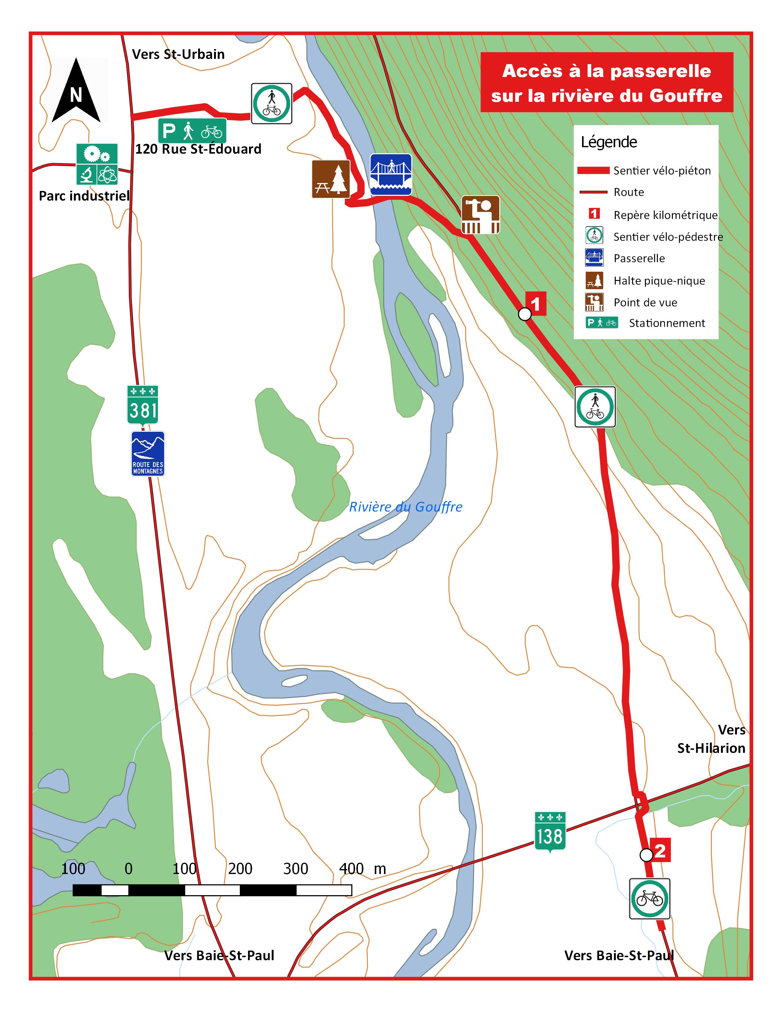
- 2 Sentier de vélos (Bicycle trail), 120, rue St-Édouard (starting at Route 381). Bicycle trail starting south of the village of Saint-Urbain. The trail has a stop near the Gouffre river. A footbridge spans the latter upstream of the island. Then the trail takes place on the east bank of the Rivière du Gouffre at the foot of the mountain, to cross Route 138 and join the Baie-Saint-Paul bicycle trail.
- Sentiers de vélo de montagne du rang St-Jérôme (Rang St-Jérôme mountain bike trails), rang St-Jérôme. The parking lot serves the Mines bike path and the Florents footpath. Various trails: the family (forming a loop bypassing a small lake), the Jacques Dufour loop, the Remontée (in zigzags), the fluid Rerrotitane and the Descente à Mic.
- 3 Sentiers de vélo La Haute Gouffre (Cycling trails La Haute Gouffre), rang St-François (route 381) (parking and trailhead are near route 381). The course of the bicycle path includes a footbridge to span the Cygnes stream, then follows it until its confluence with the Gouffre river; then the path runs along the right bank of the latter as far as the footbridge. The course has two stops with picnic table and an observation point.
- 4 Pêche sur la rivière du Gouffre (Fishing on the Gouffre river), 601, rue Sainte-Anne, Saint-Urbain (visitors' centre) (reception station on the banks of the river, near the Rang Saint-Jean-Baptiste bridge), ☏ +1 418-639-2988. Main activities: sport fishing for salmon, rainbow trout and speckled trout. There are 165 salmon pools in the Gouffre river.
Buy
editFoods and drinks
edit- 1 Centre de l'Émeu de Charlevoix - La ferme (Charlevoix Emu Centre - The farm), 710, rue St-Édouard (on the south side of the village of Saint-Urbain), ☏ +1 418-639-2606, infoboutique@emeucharlevoix.com. A unique agrotourism centre specializing in the development of emu, including emu breeding, processing, interpretation, catering and marketing. Online store offering emu products.
- 2 Charcuterie Charlevoisienne, 131, rue St-Édouard, ☏ +1 418-639-2424. Boucherie-charcuterie
- 3 Jardin de la Simplicité (Simplicity Garden), 314, rue St-Édouard, ☏ +1 418-435-8986. Cider maker
- 4 Viandes biologiques de Charlevoix (Charlevoix organic meats), 125, rue St-Édouard, ☏ +1 418-639-1111. Family farm cultivating cereals, raising cattle, as well as processing. Application of the concept of sustainable agriculture. Main products: fresh meats, cooked meats, dried meats and verrines. Virtual tour of the farm by consulting the website.
Eat
editSince March 2020, in the context of health measures resulting from the Covid-19 pandemic, several restaurants or dining rooms in Charlevoix have transformed the mode of meals at the tables into take-out or by delivery service. In general, restaurateurs have shown great resilience by updating their website, integrating interactive and automated applications for remote orders, as well as displaying the menu, opening hours, their mode of operation (e.g., by reservation, car service), health measures required (e.g., vaccination record, mask, distancing), other services (e.g ., caterer, shops, accommodation, access for the disabled, Wi-Fi, take-out, delivery), contact details and often the history of the restaurant or site. Considering the evolving context of the pandemic and government measures, it is recommended that customers obtain information from each establishment by consulting their respective website.
- 1 Casse-Croûte La Rencontre, 1116, rue St-Édouard, ☏ +1 418-639-2185. Meals on site. Take out orders.
Drink
editSleep
editInns
edit- 1 Auberge du Ravage Outfitters Moreau Lake, Lac Moreau (from Saint-Urbain, take the QC-381 North on leaving the village of Siant-Urbain, follow the green signs directing towards km 55 for the outfitter; at 55 km, turn right for 14 km (at the bottom of the descent, see the poster for the Pourvoirie du Lac-Moreau/Auberge du Ravage)), ☏ +1 418-665-4400, info@lacmoreau.com. Outfitter offering a fishing circuit.
Chalets, gîtes
edit- 2 Gîte la Bougie Verte (Lodge the green candle), 68, rang St-François, ☏ +1 418-639-2286, labougieverte@hotmail.com. Loft-style tourist residence.
Campsite
edit- 3 Camping des Pointes (Pointes campsite), 46, rang St-François (north of the village of Saint-Urbain).
Cope
edit- 5 Bibliothèque Le jardin des mots, 357, rue Sainte-Claire, Saint-Urbain, ☏ +1 418-639-2200, bibliosturbain@gmail.com. Public library.
Go next
edit
- 1 Réserve faunique des Laurentides Wildlife reserve straddling the administrative regions of Quebec Region, Saguenay-Lac-Saint-Jean and Mauricie. It covers an area of 7,934 km2 (3,063 sq mi). This wildlife reserve borders on the limit of Saint-Urbain.
- 2 Grands-Jardins National Park This park is one of the central areas of the Charlevoix Biosphere Reserve. Visitors can enjoy a number of activities here, both summer and winter: camping, canoeing, kayaking, hiking, fishing, cross-country skiing and snowshoeing.
- 3 Zec des Martres Controlled exploitation zone (ZEC) covering 424 km2 (164 sq mi), of the MRC de Charlevoix. On this territory, the main recreational tourism activities are: hunting, fishing, camping, hiking in the forest, picking wild fruits, as well as the observation of nature, flora and fauna.
- 4 Notre-Dame-des-Monts Village surrounded by mountains, offering magnificent panoramas. The summit of Gros Mont overlooks the region. The forest and mountainous nature offers many attractions, in particular ATV and snowmobile rides.
- 5 Saint-Aimé-des-Lacs A locality offering plenty of recreational and tourism activities (vacation, fishing, nautical activities, trans-Canada hiking trails and local trails in the Grands Monts sector, observation of the nautical, flora and fauna. Several organizations offer many services: the ZEC des Martes, the outfitter of Pic-Bois and the Hautes-Gorges de la rivière Malbaie national park. Among the main events, there is the Charlevoix triathlon and the Charleboix rodeo (end of June).
- 6 Saint-Hilarion The village of Saint-Hilarion overlooks the surrounding valley. Annually, a carnival is organized. Locality offering many recreational and tourist activities: resort, bowling, skating rink, cross-country skiing, snowshoeing, sliding, mountain biking, snowmobiling.
- 7 Baie-Saint-Paul Baie-Saint-Paul is a crossroads of the arts (contemporary art museum (MAC), cultural crossroads Paul-Médéric, several art work shops) as well as a town of services, shops, recreational and tourism activities. and various other attractions.
- 8 Saint-Tite-des-Caps Saint-Tite-des-Caps is a vacation and resort destination, thanks to its natural attractions near Quebec City. This rural and forest environment presents majestic landscapes on the Laurentians and the St. Lawrence River. The famous Sentiers des Caps attracts tens of thousands of visitors every year.
- 9 Petite-Rivière-Saint-François Gateway to Charlevoix, this mountainous and forest locality is a holiday destination, in particular thanks to the ski centres "Le Massif de Charlevoix" and the "Sentier des Caps de Charlevoix", as well as the Train de Charlevoix and the picturesque character of the villages: Grande-Pointe, Petite-Rivière and Maillard. These marine capes offer bucolic panoramas on the river.
| Routes through Saint-Urbain |
| Quebec City ← Baie-Saint-Paul ← | W |
→ Saint-Hilarion → Baie-Comeau |
| Saguenay ← Grands-Jardins National Park ← | N |
→ Baie-Saint-Paul → END |