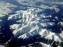
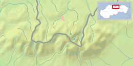
Tatra National Park (Tatranský Národný Park - TANAP; also Tatry, Tatras or Tatra Mountains) is a national park. It constitutes the highest mountain ranges in Slovakia, and extends from the northern parts of Central Slovakia to Eastern Slovakia. As the mountains form a natural border between Slovakia and Poland, a smaller part of the mountain range is located in Poland, where it is Tatrzański Park Narodowy.

Understand
editThe Tatras reside in the northern part of Slovakia, bordering Poland, and belong to Carpathian Mountains range.
History
editLandscape
edit
The national park consists of three smaller ranges:
| High Tatras (Vysoké Tatry) Most commonly visited by both foreign and local tourists. Highest peaks of Slovakia are here, as well as beautiful mountain hiking trails, ski areas, wellness and culinary places. |
| Western Tatras (Západné Tatry) A quiet and off-the-beaten part of the park. Much greener hills than in High Tatras provide plenty hiking trails - while the mountains are somewhat less high, the hikes are not really easier. Also several ski areas are present. |
| Belianske Tatras (Belianske Tatry) A small-ish protected mountainous area with a couple of beautiful light hiking trails. |
Flora and fauna
editClimate
editGet in
editThe mountain range is relatively large, though this is not obvious at first sight. The High Tatras range can be accessed by train or bus with ease, by going to the villages of Štrbské Pleso or Starý Smokovec. The other parts are much less accessible by public transport, having connections only a few times a day at most.
Thus for one day hikes to the less touristy areas, it is generally easier to take a car.
Fees and permits
editAll hiking paths are generally free to walk. For most routes, the access outside season (which is generally middle June til the end of October) is limited.
Some routes/peaks are not accessible by foot by general public and require a mountain guide - for example Gerlachovský Štít or Lomnický Štít.
Get around
editThe general public is prohibited from walking off the designated routes. Not respecting this may be costly.
Dogs are allowed, but must be leashed at all times as to not disturb wild animals. Muzzles are also required, but this may not be strictly enforced, as long as the animal behaves.
See
edit- Štrbské pleso lake (Štrbské pleso). The second-largest glacial lake and a popular tourist destination of the High Tatras.
Do
editBuy
editEat
editDrink
editStay safe
editAlmost every year, multiple casualties happen in the park. It is important to remember to let someone know where you are going and when you should return. This makes search party rescue action much faster and may significantly increase the chances of finding you in good condition. Staying outside overnight without proper equipment can be very dangerous.
Some mobile phone signal is available in the most popular valleys of the range opened towards cities. However, in the more "inner" valleys, you might not get a signal even after several hours' walk.
If you are planning on visiting the mountains, note that, as in any mountainous region, the weather can change dramatically in a matter of minutes and it can rain, snow, and hail, even in summer. Take appropriate equipment and don't underestimate the weather, especially if the weather forecast mentions storms and/or strong winds.

