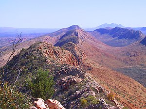
Tjoritja / West MacDonnell National Park is in the Red Centre of Australia, west of Alice Springs, 1234 km south of Darwin. It extends along the MacDonnell Ranges west of Alice Springs.

Understand
editGet in
editVehicle access to West MacDonnell National Park from Alice Springs is via Larapinta Drive and Namatjira Drive. From the direction of Uluru - Kata Tjuta National Park, the unsealed Red Centre Way (4WD recommended) connects Watarrka National Park (Kings Canyon) with West MacDonnell National Park. Simpsons Gap is also accessible via a 17-km sealed bicycle track beginning opposite Flynn's Grave, 7 km from Alice Springs along Larapinta Drive.
Fees and permits
editGet around
editSee
edit

Heading west on Larapinta Drive from Alice Springs, you'll see signs for the following (in order):
- Simpson's Gap
- Stanley Chasm
At this point there's a turnoff for Bullen Road which loops back towards Alice Springs and passes through Honeymoon gap. If you decide not to take that turnoff, a little further on the road splits: Larapinta continues southeast and Namatjira continues northeast. They are both sealed roads, which form a fork which is connected on the ends by a dirt road.
On Namatjira you see:
- Ellery Creek Big Hole - is a big natural waterhole. Great for swimming, although beware - it is cold - even in the middle of summer - so watch out for signs of Hypothermia and don't swim alone.
- Serpentine Gorge
- The Ochre Pits
- Ormiston Gorge
- Glen Helen Gorge - end of the road, literally. All after this are 4WD.
Past Glenn Helen is a 4WD track which leads west, then south to meet up with the end of Larapinta. A permit is required; on the 4wd track you'll find:
- Redbank Gorge
- Roma Gorge - Aboriginal rock art.
- Haast's Bluff
- Tyler's Pass
- Gosse Bluff and Gosse Crater, also known as Tnorala - a massive meteor crater. Registered sacred ground, a permit is required to travel the road (available at Kings Canyon, Hermansburg and Glen Helen) and overnight camping is not permitted. It's not on the direct road from Alice to Uluru, but on the Merrereni loop road. There are 4WD tracks, picnic tables, and walking tracks. The dreamtime story told is worth a read; it's really an amazing place.
The next stop down is Hermansburg, which is the far end of the sealed Larapinta Drive. The following are the points of interest leading back into town from the end of Larapinta Drive:
- Hermannsburg (Western Arrenda name - Ntaria - pronounced "Ndarra")- an Aboriginal community, famous for their ladies Choir, pottery, painting, and for being the home of the late Albert Namatjira. It's the site of an old Lutheran mission, with the best Apple Strudel in Central Australia. Whats even better is that its now an Aboriginal enterprise, providing training and employment for some of the local people. Sealed roads all the way.
- Palm Valley - a high clearance 4WD side-track off Larapinta - recommended for expert 4WD's only due to soft sand and rock driving.
- Wallace Rockhole - short 4WD side-track off Larapinta - Experience tours and a taste of life in an Aboriginal Community.
- Owen Springs - 4WD track which connects Larapinta to the south Stuart Highway; some ruins and scenic areas.
- The Finke River Track is a really lovely 4WD track which leads south from Hermannsburg - but should definitely only be used by experienced four-wheel drivers, as there's every hazard you can imagine for a four wheel drive vehicle. Heads south towards King's Canyon. Track is not marked! Boggy Hole is the main destination camping site for the Finke River Track.
Do
edit
The Larapinta Trail (+61 8 8951 8250, ) runs for 223 km along the backbone of the West MacDonnell Ranges from Alice Springs to Mt Sonder. The grandeur and timeless beauty of the Ranges are the backdrop and setting for the Trail, which is divided into twelve sections, providing you with an opportunity to experience an ancient landscape at your own pace.
Buy
editEat
editNo restaurants outside the Glen Helen Resort. Bring your own food.
Drink
editSleep
edit- Ormiston Gorge has a camping area with facilities, while Serpentine Chalet and 2-Mile (both 4WD only destinations) provide camping sites with no facilities.
- 1 Glen Helen Resort, Namatjira Drive, ☏ +61 8 8956 7208. Check-in: 2PM, check-out: 10AM. Has a cafe, restaurant, camping and accommodation.
Stay safe
editGo next
editAlice Springs, Finke Gorge National Park, Watarrka National Park, Lake Lewis, Lake Bennett

