Johnmartindavies

Johnmartindavies
Please click on icons to enlarge and obtain more information about images.
The hulk of the Brianna H was recorded by the shipping website "marinetraffic.com" , including port of registration. Dimensions and photograph with location were recorded at . This position is just off the Careenage, Bridgetown Barbados. Location 13.107°, -59.634°, Port of Registration Kingstown, St Vincent and the Grenadines, the picture was taken 4th of February 2014. Ship Type Cargo, Length × Breadth 54.92 X 9.22 in metres. The website lists four previous names.
She is also listed on the website "shipspotting.com" . The photo taken in 2012 shows how close she lay to Carlisle Bay and indicates:-
Gross tonnage: 658 tons Summer DWT: 749 tons Build year: 1965, Former name(s): - Connie (Until 2009) - Jade (Until 1994 Sep) - Franz Held (Until 1982) - Mignon (Until 1970).
The Barbados Nation of August 28th 2014 recorded the spontaneous sinking of the Brianna H on Sunday August 3rd 2014 during heavy rain.
When divers are introduced to a new wreck they generally like to know as much as possible about the unfortunate ship before it sank, the circumstances leading up to the sinking, and about any casualties so as to accord them proper respect. It can be quite disturbing to unexpectedly encounter a human skull on a wreck, as happened to a friend of mine because of inadequate information. Thus any documented information should be as complete as possible, not truncated for the benefit of editors not currently diving. Furthermore a Dive Guide carries a greater risk of Safety considerations and litigation than a pleasant stroll around Provincetown, Massechusetts.
The wreck was marked by a large yellow buoy attached by rope to the stern in February 2016. Because of its location close to the Careenage and Carlyle Bay anchorages, she is an ideal introductory wreck dive, with adequate visibility (about 8 metres) and generally slight currents. Although the sea bed is 25 metres and too deep for novices, the decks and superstructure are much shallower. Furthermore after years afloat in the bay there appear to be no hazards at present. Finally she sits perfectly upright on the coarse sand and seems untroubled by silt.
It was dived in February 2016 with Ram Edghill from his boat "Scotch'n'Soda". The dive and photographs obtained were used to inform this guide. Further photographs, observations and constructive navigation advice from experienced divers and boat handlers would enhance this guide. A second dive occurred with Ram on 15th November 2016 and allowed further photographic opportunities.
As the diver enters the water from the back of the boat moored to the buoy, the wreck is not visible from the surface. When he or she fins down into the gentle current for about 2 minutes in the direction of the rope to about five metres below the buoy the stern of the wreck becomes visible. The wreck is so new that there is very little growth so far though fish and invertebrates are colonising her. Navigation is very easy in regards to direction and according to the depth ypu have planned. Inexperienced divers should stick with their guide and not venture away from the wreck. The visibility, lack of serious current and tying of the buoy means that a safe ascent should not be difficult providing the rules about decompression avoidance are observed. More experienced divers will realise that current and visibility can vary from day to day at the same site, and buoys are often moved or removed. Safe return to the boat is top priority. The wreck is too far away and in waters that are too busy, to consider as a shore dive.
As GPS does not work under water, all locations of photographs refer to point of entry to water. Photograph depths have been synchronised by times on photograph and Dive Computer.
 Descent onto the Wreck of the Brianna H in a slight current and 8 metres visibility. Camera Depth 10.4 metres.
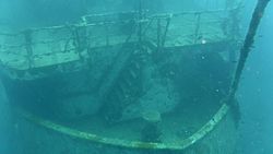
 The stern of the Brianna H. Camera Depth 12.2 metres.
 The Name and Registration port is starting to fade. Camera Depth 16.2 metres.
 The superstructure of the Brianna H from the stern. Camera Depth 17.7 metres.
 A companion way on the wreck of the Brianna H with Hakim. Camera Depth 19.2 metres.
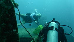 Ram Edghill on Brianna H. Camera Depth 18.9 metres.
 The Crane Cabin on the Brianna H. Camera Depth 16.7 metres.
 Another view of Ram Edghill on the Brianna H. Camera Depth 17.7 metres.
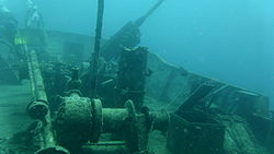 One of the winches on Brianna H. Camera Depth 16,5 metres.
 Ram goes over the Bow of Brianna H. Camera Depth 15.5 metres.
 Ram goes down off the bow of Brianna H. Camera Depth 15.2 metres.
 "See you down there". Camera Depth 15.5 metres.
 The Anchor Chain of the Brianna H from above. Camera Depth 15.2 metres.
 The Crane on Brianna H. Camera Depth 17.7 metres.
 A capstan the Brianna H. Camera Depth 19.5 metres.
 A deserted companion way on the Brianna H. Camera Depth 19.2 metres.
 Wild life on the sea bed beside the Brianna H at 23 metres. Camera Depth 22.3 metres.
 The anchor chain below the bow of the Brianna H. Camera Depth 23.2 metres
 The anchor chain of the Brianna H at 24 metres. Camera Depth 23.2 metres.
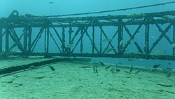 The Jib of the crane on Brianna H. Camera Depth 17.7 metres.
 The bridge of the Brianna H viewed from the bows. Camera Depth 17.7 metres.
 One of the holds of the Brianna H. Camera Depth 15.8 metres.
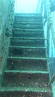 One of the stairwells of the Brianna H. Camera Depth 19.2 metres.
 The way to the surface from the wreck of the Brianna H. Camera Depth 19.5 metres.


The next photographs were taken in November 2016. Visibility appeared slightly poorer than in the previous February, but there had been a lot of rain in the preceding weeks.
 Stern of the wreck Brianna H in November 2016.
 Weed obliterating the name of Brianna H after fifteen months underwater.
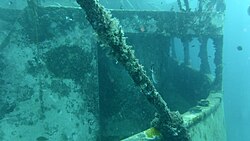 Rear entrance to the Starboard Companion Way on the Brianna H.
 Sea bed on Starboard side of the Brianna H.
 John fishing below starboard gunwale of the Brianna H.
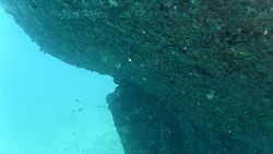 Top of the rudder of the wreck of the Brianna H.
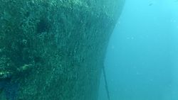 The starboard bow and anchor chain of the Brianna H.
 Bridge of Brianna H seen from the Bow.
 A feather star on the wreck of the Brianna H.
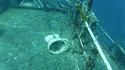 An abandoned toilet bowl on the deck of Brianna H.
 Inside a hold on the Brianna H.
 Stacie Brunetteau from Winnipeg in one of the holds of the Brianna H.
 The Exit from one of the holds on the Brianna H.
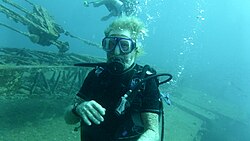 Ram Edghill leading divers on Brianna H.
 Port Bow on Brianna H. No Klingons on this bow.
 A Scrawled Filefish on the deck of the Brianna H.
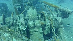 Winch on Brianna H
 John fishing below the Starboard deck rail of Brianna H looking forward.
 Looking up to the bows of the Brianna H.
 A Sea Cucumber on the deck of the Brianna H.
 John had a decent catch including a lobster on Brianna H
 Stacie Brunetteau from Winnipeg going up the line from Brianna H.


