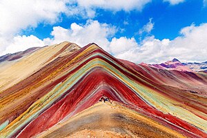
The Southern Sierra is the region of Peru that includes the departments of Ayacucho, Apurimac, Cuzco and Puno. This region is characterized by high mountains and steep, deep valleys. Many roads are unpaved. Thus, travelling is often somewhat troublesome and slow, but the scenery is amazing.

Regions
edit| Sacred Valley of the Incas This valley holds many famous and beautiful Inca ruins, including Machu Picchu, Choquequirao, and Sacsayhuamán. |
Cities
edit- 1 Abancay — a base for visiting the Ampay National Sanctuary, and the Clouded Forest of the Amazonian Basin
- 2 Andahuaylas — the capital of the Andahuaylas Province known as the "prairie of colored clouds")
- 3 Andahuaylillas — its church is described as the "Sistine Chapel of America"
- 4 Andagua — the major centre for visits to the Valley of Volcanoes
- 5 Ayacucho — home of the Morocucho people, a group of the Quechua
- 6 Cachora — the most popular starting point for travelers who want to see the Inca site Choquequirao
- 7 Chahuay — a district with outstanding history, architecture, and culture
- 8 Chinchero — its ruins are a series of nested terraces rising up to a plateau upon which sits a church built in the early 1600s
- 9 Cuzco — one of Peru's most visited cities as it is the largest and most comfortable city from which you can begin visits to Machu Picchu, the Sacred Valley, and other Inca sites in the region
- 10 Huancavelica — has eight churches from the colonial era
- 11 Huancayo — known for the crafts and the many festivals of the surrounding towns
- 12 Jauja — its main church dates back to 1564
- 13 La Merced — close to the waterfalls Catarata de Bayoz and Velo de la Novia
- 14 Paucartambo — the festival of la Virgen del Carmen is a colorful festival in July
- 15 Pichanaki — known as the coffee capital of Peru, it had a diversity of birds, butterflies and fruit plantations, as well as Caverns and waterfalls
- 16 Quillabamba — take a trip out to see the beautiful waterfalls in the jungle
- 17 Santa Teresa — a four-hour hike from here will take you to Machu Picchu
- 18 Tarma — offers ruins, caves, waterfalls and a short trip to the jungle
Other destinations
edit- 1 Ausangate circuit — an extremely high-altitude 70-km hiking trail
- 2 Machu Picchu — a remnant of the once-great Inca Empire
- 3 Choquequirao — a large Inca ruin accessible only by a strenuous two-day trek
- 4 Colca Canyon — one of the world's deepest canyons, it offers a vibrant indigenous culture
- 5 Cotahuasi Canyon — more than twice as deep as the Grand Canyon
- 6 Vinicunca — impressive red-colored mountains that has stayed relatively off the beaten path until the 21st century
Understand
editGet in
edit- Alejandro Velasco Astete International Airport (CUZ IATA), is in the centre of Cusco, and has flights to Lima, Arequipa, Ayacucho, Juliaca and Puerto Maldonado. Its sole international route is to Santiago in Chile.
- Francisco Carle Airport (JAU IATA) serves Jauja, Huancayo and Tarma. Its sole route flies to Lima.
- Andahuaylas Airport (ANS IATA) has charter flights.
Get around
editYou can fly between Cusco and Ayacucho, but the most common method of travel in this region is by bus.
See
editDo
editHiking: See Inca Trail, Machu Picchu, Choquequirao, and Colca Canyon.
Eat
editDrink
editStay safe
editGo next
editInto the jungle (2-3 nights) - If you're game, fly to one of the following two lodges between Days 1 and 2, because anything after Machu Picchu is sure to be a letdown. Pack one bag and leave in Cusco what you don't need. The Manu Wildlife Center, owned by a nonprofit environmental conservation group, has the most creatures but fewer comforts. If you want a taste of the jungle in an elegant setting, go to Reserva Amazónica. The surrounding cattle ranches mean fewer wild animals, but the huts are plusher and there's a masseuse. Reserva is also a better option if you have only two nights (although three is ideal in either location) because the 30-minute charter flights to Manu are highly undependable. Reserva also offers community visits, which Manu doesn't. Wherever you land, take part in as many outings as you can.
- Manu Wildlife Center, ☏ +51-84-22-6671. three nights, US$2,370 for two people, including air.
- Reserva Amazonica, ☏ +51-84-21-1122. three nights, US$1,570 for two people, not including air.
Urubamba Weavers' Route Trek (2 nights) - The classic Inca Trail was the primary route between Cusco and Machu Picchu, but the Incas traversed hundreds of other paths, and you can as well. Instead of catching the train to Machu Picchu on Day 3, drive to the trailhead of the Urubamba Weavers' Route. This hike from Ollantaytambo to Lares takes you through villages unchanged for centuries. The first camp lies in the shadow of 17,400 ft (5,300 m) Terijuay. The middle of Day 2 marks the high point of the trek, literally — 14,764 ft (4,500 m) — after which a gradual descent leads through potato fields and into the tiny village of Cochayoq. Midway through Day 3, the trek reaches Lares and then you are returned to the Sol y Luna Lodge & Spa. It is recommended that you purchase the services of a trekking company for this hike since it is at such a high altitude. This is a moderate-to-strenuous trek, with four to six hours of hiking on each of three days and recommended for experienced hikers only. Although the spongy moss underfoot makes this a relatively low-impact route-the Inca Trail, in comparison, is paved with stones-the altitude is a challenge. If you do have trouble, you can always take a hit of oxygen from your guide's canister or jump on the "ambulance horse." If serious symptoms persist, getting to a lower altitude is essential.

