The dive site Anvil Rock is an offshore rocky reef near Cape Point on the Cape Peninsula, near Cape Town in the Western Cape province of South Africa.
Understand
editThe site is just outside False Bay, southwest of Cape Point, in the Table Mountain Marine Protected Area. It is not dived often as it is a long ride, but it may be a good second dive on the way back after diving the Lusitania at Bellows Rock.
Position
edit1 Anvil Rock 3m pinnacle: S34°22.218' E18°31.090'. The nominal position and main pinnacle at the site.
This site is in the Table Mountain National Park Marine Protected Area (2004). A permit is required.
Name
editThe name "Anvil Rock" is marked on the nautical charts of the area as a known navigational hazard.
Depth
editMaximum depth is deeper than 20 m. and the top of the pinnacle is about 3 m. (Average depth of a dive is likely to be about 18 m.)
Visibility
editNot much is known about visibility at the site, but it is probably much like Bellows Rock.
Topography
editMassive granite reef rising to a shallow pinnacle, with a smaller group of deeper pinnacles a short distance to the southwest.
Geology: Precambrian granite corestones of the Peninsula pluton.
Conditions
editThe site is exposed to wind and waves from all directions, so should be dived in calm winds and low swell. There may be strong surge and a slight current.
Get in
editAccess is by boat, usually from Simon's Town or the Millers Point slipway. The site is about (distance)km from Simon's Town jetty, or (distance)km from Miller's Point
Do
editDive at one of the drop points and explore the vicinity.
1 Anvil Rock 3m pinnacle: S34°22.218' E18°31.090'. The nominal position and main pinnacle at the site. This is a large, flat-topped shallow pinnacle rising to about 3 m, with a sheer wall on the south side dropping to more than 20 m. The west, north and east sides slope more gradually. There is a sand patch very near to the south east at 25 m, and a sand patch a bit further to the north at 31 m
2 Anvil Rock caves: S34°22.244' E18°31.068'. A deeper group of pinnacles about 13 m on top lies a bit further south, where the bottom is a bit deeper than 21 m. They are quite rugged and sheer sided, with some small caves and tight swim-throughs.
See
editMarine life
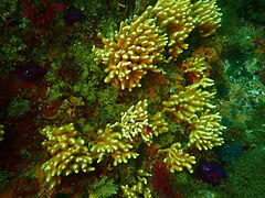
editThe marine life is typical False Bay invertebrates, with large numbers of nippled sea fans, sponges and soft corals. The upper surfaces have quite heavy kelp growth, mostly split-fan kelp, and large red-bait pods in the shallower areas. There is a predominance of purples and blues over large parts of the reef, due to thriving purple soft coral and dentate moss animals.
- Nippled sea fans Eunicella papillosa are common on the southern pinnacles
- Sponges and soft corals
- Sponge on the reef at Anvil Rock
- Strawberry anemones Corynactis annulata and dentate moss animals Virididentula dentata
- Reef invertebrates at Anvil Rock
Photography
editMacro photography is most likely toproduce good results, but wide angle may be good if the water is clean.
Suggested routes
editAt the south pinnacles, spend some time at about 20m, where there are a few small caves and swim-throughs.
Stay safe
editHazards
editNo special hazards are known, though the surge may be quite strong.
Skills
editNo special skills required, but much of the site is deeper than 18m, so it is more suited to advanced divers.
Equipment
editA light for looking into the holes and swim-throughs, and a DSMB and reel, to let the boat know where you are surfacing. If there is a current, you could drift quite a long way during the ascent, and it is a long way to shore, even if the current does not sweep you out past Cape Point into the South Atlantic.
Nearby
editOther offshore dive sites of False Bay:
- 1 Choirboys Reef
- 2 Seal Island
- 3 Drop Zone
- 4 East Shoal
- 5 Moddergat
- 6 Sterretjies Reef
- 7 York Shoal
- 8 SAS Fleur
- 9 Offshore Barges – North Barge
- 10 Steenbras Deep - South Pinnacles
- 11 Blue Flame Pinnacles
- 12 SATS General Botha
- 13 Off-Whittle Ridge
- 14 SAS Bloemfontein
- 15 Whittle Rock
- 16 Bruce's Mark
- 17 Deep South Whittle Reef
- 18 SS Lusitania
- 19 Rocky Bank
Back to the Alphabetical list of sites, or list of reef dive sites in the Southern False Bay offshore reefs area
Other regional dive sites:
- Dive sites of Table Bay and approaches,
- Dive sites of the Cape Peninsula west coast
- Dive sites of the Cape Peninsula east coast
- Dive sites of False Bay east coast
- Fresh water dive sites of the Cape Town Metropolitan Area


