Diving the SS ''Godetia''

The dive site SS Godetia is an offshore recent wreck in the northern part of False Bay, near the Cape Town suburb Macassar in the Western Cape province of South Africa.
Understand
edit
The ST Godetia was a steel steam side-trawler in the Irvin and Johnson fleet, which was sunk by the SA Air force as target practice in August 1970. The ship was built by Hall Russel & Co. Ltd. of Aberdeen as Yard #794, launched on 30 April 1946 by the wife of Richard Irvin of Richard Irvin and Sons, Ltd, Aberdeen. The vessel was 162 ft (49 m) long, with a 28 ft (8.5 m) beam and a hull depth of 14 ft (4.3 m) and was 515 gross registered tons. It was powered by a single coal fired scotch boiler and triple expansion steam engine driving a single shaft with a 4-bladed propeller.
The wreck was located by a small group of divers on the dive boat Ruby Runner, launched from Harbour Island on 4 August 2018, on an unusually calm sea. After reaching the charted position, the boat made several passes of a parallel linear search pattern using the fish-finder, and picked up a few possible hits. After about an hour two points were selected for visual search, and the second team found that their shotline had been dropped on top of the boiler. The group investigated further and mapped the extents of the debris field and position of major artifacts using a towed float with GPS tracker. The track recorded was used to draw the map.
Position
editS34°06.???' E19°44.???' 1 ST Godetia wreck, about 2.7 km offshore of Macassar. This site is not in a Marine Protected Area. A permit is not required.
Name
editThe name "ST Godetia" is the name of the vessel sunk at the site. ST stands for Steam Trawler, and Godetia is the name of a flower.
Depth
editMaximum depth is about 18 m on the sand, and the top of the boiler is at about 14 m. (Average depth of a dive is likely to be about 16 m)
Visibility
editThis is an area where the south westerly swells usually reach the shore, and the surge will usually be significant. Visibility is likely to be poor most of the time, though it was about 10 m on the day the wreck was found. This is probably unusually good.
Topography
editThe bottom in this area is scattered patches of low to medium profile rocky reef on sand.
Geology: The reef is sedimentary rock, probably of the Pre-Cambrian Tygerberg formation of the Malmesbury Group, which forms the regional geological basement in the Cape peninsula. The strike is roughly north/south, and the dip appears to be very steep.
Conditions
editThe site is exposed to south westerly swell, and wind from all directions, though the fetch is relatively short for winds from the north, so should be dived in calm conditions with low swell.
Get in
editThe site is too far offshore for shore dives, and can only be dived from a boat. The site is about 12.5 km from Harbour Island, 13.6 km from Gordon's Bay Old Harbour, and 29.5 km from Simon's Town jetty.
See
editMarine life
editFeatures
editWreckage of a steel hulled steam trawler. Most of the hull structure is thoroughly broken up, but the boiler, engine block, propeller, and rudder blade are clustered together, and would form the focal point of a dive.
 Divers returning to the boat
 Boiler
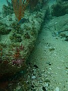 Rudder blade
 Propeller
 Diver at the boiler
 Grating
 Top of the boiler


Photography
editIf the visibility is good, wide angle or fisheye photography may give good results, otherwise there is a lot of encrusting invertebrate growth and macro is likely to give better results. The water is fairly shallow, and natural lighting may be quite good, but it is worth taking a flash or video light.
Suggested routes
editThere are no specific routes recommended, but the area around the boiler and to the east have the largest and most identifiable wreckage fragments.
Stay safe
editHazards
editThis is an area known to be frequented by cruising great white sharks at some times of the year, and there is a section of wreckage with a space underneath which is large enough to swim underneath, that could be a hazard.
Skills
editNo special skills are required. The site is shallow enough for entry level divers.
Equipment
editNo special equipment recommended.
Nearby
edit
Other offshore dive sites of False Bay:
- 1 Seal Island
- 2 Drop Zone
- 3 East Shoal
- 4 Moddergat
- 5 Sterretjies Reef
- 6 York Shoal
- 7 SAS Fleur
- 8 Steenbras Deep - South Pinnacles
- 9 Blue Flame Pinnacles
- 10 SATS General Botha
- 11 Off-Whittle Ridge
- 12 SAS Bloemfontein
- 13 Whittle Rock
- 14 Bruce's Mark
- 15 Deep South Whittle Reef
- 16 Anvil Rock
- 17 SS Lusitania
- 18 Rocky Bank
Back to the Alphabetical list of sites, or list of wreck dive sites in the False Bay offshore area
Other regional dive sites:
- Dive sites of Table Bay and approaches,
- Dive sites of the Cape Peninsula west coast
- Dive sites of the Cape Peninsula east coast
- Dive sites of False Bay east coast
- Fresh water dive sites of the Cape Town Metropolitan Area