Diving at Tafelberg Deep

The dive site Tafelberg Deep is an offshore rocky reef in the Hout Bay area of the Cape Peninsula, near Cape Town in the Western Cape province of South Africa.
Understand
edit
This site is not well explored, and is used mostly by divers who want a dive in the 40 to 50 m depth range which can be ended in shallower water.
Position
edit- 1 Tafelberg Deep Pinnacle: S34°04.6476’ E018°18.9710’, 18 m deep
Bearings:
- 190m at 355°magnetic from Wilhelm's Mark to Tafelberg Deep Pinnacle
- 300m at 307°magnetic from Mac's Mark to Tafelberg Deep Pinnacle
- 450m at 026°magnetic from Mac's Mark to Klein Tafelberg Pinnacle
This is the extreme southern end of the known reef in the Tafelberg Reef area and is the southern edge of the south-easternmost part of the reef complex extending south from the Karbonkelberg. It is an area of relatively steeply shelving reef, as the average slope from the reef edge to the pinnacle is about 1 in 5. It is about 500 m south west of the pinnacle at Klein Tafelberg Reef
This site is in the Table Mountain National Park Marine Protected Area since 2004. A permit is required.
Name
editThe name "Tafelberg Deep" refers to the adjacent Tafelberg and Klein Tafelberg reefs, and that the depth is greater. The Tafelberg Deep Pinnacle is the nearest pinnacle to the deepest edges of the reef.
Depth
editMaximum depth is about 50 m at the edge of the reef, and the top of the pinnacle is about 18 m. It is about 190 m from Wilhelm's mark to the pinnacle, on an upward slope of about 1 in 5 average gradient. It should be quite easy to navigate as the direction is about 355°magnetic, which is almost directly North, and almost continuously uphill.
Topography
edit
Tafelberg deep is the southeastern end of a large granite reef which probably extends continuously at least as far as Di's Cracks to the northwest. Further southeast is sand bottom, for an unknown distance. The first sand patches between rocks have been found at 41 m to the south, and this increases to about 50 m maximum depth for the reef edge. The site has a shallow point at a cluster of pinnacles reaching up to about 18 m
Geology: Pre-Cambrian granite of the Peninsula pluton. Sand at the bottom to the south.
Conditions
editThe site is exposed to south westerly swells, which can cause a surge. The site is usually at it's best in summer but there are also occasional opportunities in autumn and winter. Short swells will often not affect the bottom conditions due to the depth.
This is an area which sometimes has upwellings, caused by strong south easterly winds, resulting in cold clear water, which may develop a plankton bloom over a few hours, which will reduce the visibility again.
Keep a lookout for times when the south west swell is low and short period, and there is not too much south easterly wind forecast.
Get in
editThe site is only accessible by boat. It is about 5.3 km from Hout Bay Harbour.
Do
editDive at one of the listed drop points and explore the reef around that point, or follow one of the routes.
2 Tafelberg Deep Pinnacle: S34°04.6476’ E018°18.9710’, 18 m deep. A huge outcrop of granite with a cluster of pinnacles. Very steep profile at and near the top, flattening out below about 24 m to the south. Moderately to steeply sloping slope of granite boulders and outcrops to the south. There is a ridge several metres high interrupting the slope to the south.
3 Wilhelm's Mark: S34°04.7360’ E018°19.0322’, The sand edge runs roughly east-west for about 200 m and is very close to the 50 m contour. Wilhelm's mark is on this sand edge at the shortest horizontal distance from the main pinnacle, and is a suitable place to drop divers who want a 50 m dive and who want to follow the reef up for a reasonably long bottom time, with or without obligatory decompression.
4 Mac's Mark: S34º04.6810’ E018º19.1633’, An alternative drop point for a 50 m dive. It should be possible to navigate from this point to the pinnacle by going generally uphill and north. Some decompression should be expected, but could be minimised by careful gas planning
5 Coral crag: S34º04.6872' E018º18.9658', A sharp dropoff about 6 m high at 36 m on the ridge from the sand edge which leads up towards the main pinnacle, a bit to the south of the shortest route, It is crowned by an unusually thick and sparsely branched morph of noble coral, and may have several basket stars. Very pretty on a good day.
6 Brittlestar pinnacle: S34º04.6578' E018º18.9312', 26 m deep
See
editMarine life
editThe reef life tends to have more sponges due to the depth, but is otherwise similar to other reefs in the area. The seldom seen Gilchrist's sea urchin and cobbled seastar have been recorded from this site. The noble corals at the deep coral crag are unusually thick, and less branched than is usual in this region. High densities of the hairy brittle star Ophiothrix fragilis may occur.
 Coral on the deep reef
 Sponge with crab on the deep reef
 Sponge on the deep reef
 Brooding cushion star on the deep reef
 Some of the upper parts of the reef were heavily covered by hairy brittle stars
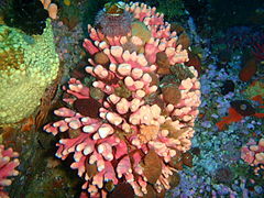 Noble coral with an unusual number of invertebrates sheltering between its branches.
 Two colour morphs of striped anemones at the pinnacle
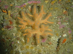
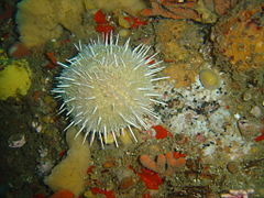 Gilchrist's sea urchin on the deep reef
 Sponges and sea cucumbers near the pinnacle
 Cobbled seastar Calliaster baccatus at about 36 m
 An unusual morph of noble coral Stylaster nobilis at the coral crag
 Another unusual morph of noble coral at the coral crag


Photography
editThe site is mostly quite deep and often quite dark. Natural light will not be sufficient most places and times, and be sure that your camera housing is rated to the depth. Macro equipment is most likely to produce useful results, particularly in the deeper areas.
Suggested Routes
editThe recommended procedure is for the skipper to find the desired depth using echo sounder and GPS, and put down a shotline. Divers descend on this and swim a compass course toward the Tafelberg Deep pinnacle, on a bearing calculated by the skipper from the GPS positions of the two points. However, it is possible for divers to run out of planned bottom time before reaching the pinnacle, in which case they should deploy a DSMB and surface on that.
Stay safe
editHazards
editNitrogen narcosis, decompression sickness, Cold water.
Skills
editCertification and skills for diving to 50m and using the appropriate equipment.
Equipment
editCompass and DSMB with reel or spool are necessary due to the nature of the dive. Trimix and deco gas strongly recommended. Dry suit and light recommended.
Nearby
edit
Back to the Alphabetical list of sites, or list of dive sites in the Outer Hout Bay area
Other regional dive sites:
- Dive sites of Table Bay and approaches
- Dive sites of the Cape Peninsula east coast
- Dive sites of False Bay offshore and approaches
- Dive sites of False Bay east coast
- Fresh water dive sites of the Cape Town Metropolitan Area