Diving the Cape Peninsula and False Bay/Vulcan Rock

The dive site Vulcan Rock is an offshore rocky reef in the outer Hout Bay area on the Atlantic seaboard of the Cape Peninsula, near Cape Town in the Western Cape province of South Africa. .
Understand
edit
Vulcan Rock is the highest point of an extensive area of granite reef which is probably continuous from Klein Tafelberg and Tafelberg Deep to the southeast, to Di's Cracks to the northwest, and breaks the surface at most states of the tide. It is low and flat on top and big enough to park a car. If there are extensive whitecaps it may be difficult to see from a distance, so it can be tricky to find on a day with low swell, high tide, and a strong south easterly wind unless you have GPS. A spectacular dive if the visibility is good.
From the map it is apparent that Di's Cracks, Vulcan Rock, and Rocksucker Ridge are the remaining high areas of a large granite ridge running northwest to southeast.
Position
editName
editThe exposed rock marking the site is shown on charts of the area as "Vulcan Rock."
Depth
editThe top of the rock extends above the water. Maximum depth is over 30 m but this is some way from the rock, probably to the south-west. There is a lot to see in the 10 to 20 m range and staying in this depth range will allow an adequately long dive for most divers. The main feature of the site, the big swim-through, is in the 18 to 20 m depth range.
Visibility
editVisibility is variable and can range from more than 20 m on a good day to less than 3 m on a bad day. A strong persistent south easterly wind will usually move the surface water offshore and cause an upwelling of cold clear water which will temporarily improve visibility. The visibility in such a case may improve overnight, and may deteriorate almost as quickly if the wind stops and there is a day of bright sunshine, which stimulates a plankton bloom, also locally called a red tide. A red tide can drop surface visibility down to less than 5 m in a day, but in these cases there may well be reasonable visibility below the surface layer, though it will probably be quite dark, and the light very green.
Poor visibility is also associated with north westerly winds. Good visibility occurs less frequently in winter, but may last longer as there is less sunshine to power an algal bloom.
Topography
editVulcan Rock is the exposed rock at the top of a very big granite tor in a cluster of pinnacles running northwest to southeast, on exposedbedrock extending down to at least 28 m. To the northeast of the exposed rock is a long ridge with a central cluster of pinnacles running northwest to southeast, with the shallowest pinnacle rising to within about 3 m of the surface.
Southwest of the exposed rock, the topography is very rugged, and slopes down to a fairly large sand patch about 28 to 30 m deep
There is an extensive area of relatively low profile reef to the west of Vulcan Rock and northwest of the sand patch. Much of it is about 24 m deep and there is a 14 m pinnacle on a compact ridge in this area.
To the southeast of the main reef there is another cluster of high pinnacles at Rocksucker Ridge, about 12 m deep on top.
Further to the northwest is the dive site Di's Cracks, traditionally considered a separate site, and separated from the Vulcan Rock reef by a relatively deep gap that has not yet been surveyed.
Geology: Granite of the late Pre-Cambrian Peninsula pluton, with patches of white quartz sand.
Conditions
editThe site is exposed to south westerly swells, which can cause a strong surge. The site is usually at its best in summer but there are also occasional opportunities in autumn and winter.
This is an area which sometimes has upwellings, caused by strong south easterly winds, resulting in cold clear water, which will usually develop a plankton bloom over a few hours to days, depending on the sunshine, which will reduce the visibility again.
Keep a lookout for times when the south west swell is low and short period, and there is not too much south easterly wind forecast. The south easterly wind will usually improve visibility, but if it blows too hard, can make the trip out to the site uncomfortable, and the trip back quite unpleasant. What you want is a few days of low south westerly swell with strong south-easters in the afternoons, and quiet mornings, when there is very little wind chop and there has not been time for a plankton bloom to develop. For this reason, most dives to this area are scheduled for early launches.
Get in
editThe site is accessible only by boat. It is about 5.5 km from Hout Bay Harbour. Anchoring is possible, but not recommended, as the bottom is very rugged and anchors and even shotlines often foul.
Do
editDive at one of the listed sites, and explore the vicinity, or explore an uncharted area and let us know what you find.
1 Vulcan Rock: S34°03.945’ E018°18.545’. The exposed rock is the top of a very big granite tor. It is made up of large corestones on top of more of the same, down to at least 27 m . There are lots of crevices, overhangs and fairly narrow gaps. Boulders are often several metres high. There is usually a knocking sound as loose boulders are rocked by the swell.
There is a swim-through cavern directly under Vulcan rock. The bottom is at 18 m, the roof about 2 m higher. There are four separate entrances, none of them easy to see from outside unless at the same depth. The cave is probably between 20 and 30 m maximum extent, and maybe 20 m wide at the widest. Two of the entrances are at the edges of the relatively flat floored part, and the other two are across boulder strewn bottom and irregularly shaped. There is also an air trap overhang on the north east side of the main boulder at about 13 m depth with a number of small domed pockets in the ceiling which are bare of all growth, showing that there is often air in the overhang, and that it is most likely accumulated from bubbles in the water caused by breaking swells.
There are big boulders or pinnacles to both sides of one entrance to the northeast. The next entrance anticlockwise is at the bottom of a little gully, and has a small cave to the right of the entrance to the main cave.
2 North Ridge Pinnacle: S34°03.912’ E018°18.545’. To the north of the exposed rock is a long ridge running northwest to southeast, with a cluster of pinnacles a short distance to the northeast, with the shallowest pinnacle rising to within about 3 m of the surface.
3 West Ridge Pinnacle: S34°03.962’ E018°18.447’. A compact row of huge boulders to the west of the exposed rock, rising from the bedrock about 25 m deep to a minimum depth of about 14 m, with a fairly large swim-through at about 23 m depth near the east end on the north side. The ridge is about 60 m long in the northwest–southeast direction, roughly parallel to Vulcan Ridge, and about 20 m wide, with very steep sides and large overhang crevices under some of the boulders that might be accessible with side-mount.
4 Rocksucker Ridge West Pinnacle: S34°04.033’ E018°18.683’. A fairly large cluster of huge boulders about 55 m long from east to west and 30 m wide north to south at 15 m, rising to flattish tops at around 11 to 15 m, riven by huge cracks extending to below 24 m in places. The near vertical walls of the cracks are covered in a diverse encrustation of sponges and soft corals, and the flat tops have small kelp forests. A spectacular site in good visibility, first recorded as a dive site by divers from the Blue Flash boat in January 2023, though the presence of the ridge is shown on the SA Navy charts as a couple of spot depths and vague contours. The north side slopes down quite steeply in places, but more gradually in others. The gap between this ridge and Vulcan Rock south side has sand patches of unknown extent at a depth of about 28 m. and is probably sufficiently separated to consider this a different site. Most divers would not cross between the areas for Vulcan Rock and Rocksucker Ridge during a dive, but it would not be difficult.
5 Rocksucker Ridge East Pinnacle: S34°04.037’ E018°18.676’. The east end of the ridge, and probably the high point. A relatively large flattish area above the 12 m contour, split by some deep narrow gullies. Probably much like the west pinnacle area, but not fully mapped yet. There is more relatively shallow reef between the east and west pinnacle areas.
See
editMarine life
editHeavy growth of red bait in shallower parts, Some kelp, probably mostly Split-fan kelp, on top surfaces down to about 15 m. Heavy encrustation of sponges, sea fans, bryozoans and colonial hydroids on steep faces, and particularly under overhangs. Flatter rock surfaces in deep areas are often covered by urchins and grey sea cucumbers.
Vulcan Rock:
 Crowned nudibranchs
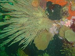 Grey fan hydroid
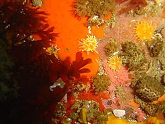 Reef life at Vulcan Rock
 Noble coral
 Shoal of Hottentot


Rocksucker Ridge:
 Yellow soft corals
 Tube sponges
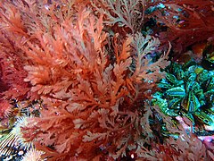 Plocamium seaweeds
 Rock crab on kelp stipe
 New growth of small mussels
 Large ascidian with sponge encrustation
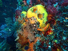 Yellow sponge


Features
editThere are several caverns and other holes between and under the boulders. The best known is directly under the exposed rock, at a depth of about 15 m. It is large and has several access openings around the sides (about 4) The inner space is about 2 to 3 m high in places and is probably over 10 m wide and long. The entries are not particularly obvious, and are often missed, though they are quite large. From the inside they are very obvious.
There is also a small "balloon cave" overhang, where the roof is domed. It is on the east side of the exposed rock, at a similar depth to the main cavern, between the northeast and southeast openings. The balloon cave will trap air, which if allowed to accumulate, will kill the invertebrate growth on the roof, so try not to breathe inside this cave.
Some time back in the late 20th century, an advertisement was filmed of a car standing on Vulcan Rock. The story goes that it was placed by helicopter, and when they came back to fetch it the next day it was gone. No trace has ever been reported, and a closed motor vehicle with widows rolled up does not sink very fast, so it may have come to rest some way from the pinnacles. Who knows, some day someone may find some part of it.
At Rocksucker Ridge there are a few deep cracks splitting the ridge from north to south The top edges are fairly sharp, though heavily encrusted, and the walls and edges are not heavily weathered as is the norm for corestone landforms. The two main cracks are wide enough to swim through comfortably at 15 m, and possibly also at about 18 m. The one to the east is quite straight and you can see the other end, while the other (to the west) is curved sufficiently that one can only see part of the way. There are also a few overhangs near the bottom of the cracks and under boulders.
 The big swim-through cavern directly under Vulcan Rock
 One of the cracks at Rocksucker Ridge


Photography
editGood site for photography, specially close-up shots of invertebrates. Macro will almost always be useful, and wide angle/fisheye can give some spectacular results on a really good day.
Routes
editChoose a route to suit your desired profile. For greater depth go west. There is a large swim-through under the main pinnacle at about 18 m depth, and the area around the group of pinnacles is the most popular part of the site.
Stay safe
editHazards
editCold water, Strong surge in cracks and swim-throughs. Sea urchins. Strong offshore winds may develop over a short time, making it tricky to spot divers on the surface, and a wet trip back.
Skills
editNo special skills required, though the ability to deploy a DSMB is useful in case you are separated from the group or need to surface away from the shot line, or if no shot line is used.
Equipment
editThe site is cold and relatively deep, and a dry suit is recommended. This is a dive site where the use of Nitrox can be worthwhile to extend no-stop time. A reel with DSMB, Light and Compass are also recommended.
Nearby
edit
- 1 Seal Island
- 2 Di’s Cracks
- 3 Tafelberg Reef
- 4 Klein Tafelberg Reef
- 5 Tafelberg Deep
- 6 Tafelberg Deep Pinnacle
Back to the Alphabetical list of sites, or list of dive sites in the Outer Hout Bay area
Other regional dive sites:
- Dive sites of Table Bay and approaches
- Dive sites of the Cape Peninsula east coast
- Dive sites of False Bay offshore and approaches
- Dive sites of False Bay east coast
- Fresh water dive sites of the Cape Town Metropolitan Area