Diving at Tafelberg Reef

The dive site area Tafelberg Reef is an offshore rocky reef in the outer Hout Bay area on the Atlantic seaboard of the Cape Peninsula, near Cape Town in the Western Cape province of South Africa.
Understand
edit
Tafelberg reef is one of the closest reef areas to Hout Bay with depths below 24&npsp;m, which can be useful for training purposes. It is also biodiverse and topographically interesting, making it a versatile dive site, and though most of it is a bit deep for entry level divers, there are sites within their recommended depth range. The part covered in this page is the central section, less popular and familiar than the south eastern sites at Klein Tafelberg and Tafelberg Deep, and the north-western sites at Vulcan Rock and Di's Cracks. Tafelberg Reef includes the recorded dive sites at Cowrie Caves, Tafelberg Reef North and Tafelberg Reef West. The nominal position is based on the S.A. Navy chart of the area which is marked with the name at the shallowest officially charted part of the reef. Much of the reef has been recently surveyed using multibeam sonar in fairly high resolution by the S.A.Council for Geoscience, but the data does not appear to have been published yet.
Position
edit1 Tafelberg Reef: S34°04.220' E018°18.930' (nominal position, based on the Navy charts). This site is in the controlled area of the Table Mountain National Park Marine Protected Area, just south of the border of the Karbonkelberg restricted area since 2004. A permit for recreational diving is required.
Name
editA large area of reef off the Karbonkelberg headland to the south west of Hout Bay, is marked "Tafelberg" on the charts. The reef extends continuously from the Vulcan Rock area to the north west, to the Klein Tafelberg area in the south east. Tafelberg translates to Table Mountain.
Depth
editMaximum depth is about 30 m, top of the reef about 8 m at the highest pinnacles. Most of the diving is probably between 15 m and 30 m.
Visibility
editThis is an area where visibility may be better than average for the west side of the Cape Peninsula. On a good day it can exceed 20 m, but 10 m is more likely. Good visibility is often associated with several days of strong south easterly wind which causes upwelling of clear, cold water from the depths. This water is often rich in dissolved nutrients, and if the wind is followed by a few days of bright sunshine, there may be a plankton bloom, also known as a 'red tide' which may decrease the visibility, particularly in the surface layers. However, the deeper water may still be relatively clear, though the light levels will be less and the water will be much greener.
Topography
editRugged granite corestone outcrops with high relief and sand bottom at about 29 m to the west and 30 to the north. There are deep crevices and gullies. There is not much overhang, but a lot of vertical faces. The site is very rugged and spectacular in good visibility. It tends to flatten out around 24 deep to the northeast.
Geology: Granite of the late Pre-Cambrian Peninsula pluton
Conditions
editThe site is exposed to south-westerly swells, which can cause a strong surge. The site is usually at its best in summer, when the swell is likely to be lower, but there are also occasional opportunities in autumn and winter.
This is an area which can have upwellings, caused by strong south easterly winds, resulting in cold clear surface water, which may develop a plankton bloom over a few hours of strong sunshine, which will reduce the visibility again. There is often a slight surface current due to recent local wind. This is usually the same current that causes the upwellings.
Keep a lookout for times when the south west swell is low and has a short period, after a day or two of strong south-easterly wind. These particularly good conditions are more likely in La Niña years, when the south-easterly winds tend to be stronger, and less likely in El Niño years, when the south-easterlies are likely to be weaker.
On very rare occasions, there is world class big-wave surf over Tafelberg Reef, but this occurs far less often than at the nearby "Dungeons" break. No-one will be diving by choice, but the occasional tow-in surfer may wipe out badly.
Get in
editThe site is only accessible by boat. It is about 4.5 km from Hout Bay Harbour. Boats may anchor, but conditions are usually more appropriate for live-boat dives.
Do
edit
Dive at one of the known drop points listed here, and explore the local reef around each point. Alternatively, dive at an unsurveyed place and let us know what you find.
1 Cowrie Caves: S34°03.934' EE018°18.890', is a cluster of boulder pinnacles in the northern part of Tafelberg Reef. The shallowest point is about 16&npsp;m deep and about four rocks rise to shallower than 18 m, The reef above 21 m is somewhat more than 50 m long from northwest to southeast and about 25 m wide. Maximum depth in the immediate vicinity is probably about 24 m,and there does not appear to be sand bottom nearby. It is a short distance to the north-west of the Tafelberg North mark. The cluster of shallower pinnacles has a small talus cave, and there are several other small caves and swimthroughs at the site. The top of the reef has a sparse split-fan kelp forest. There were also a fair variety of sessile invertebrates and other benthic organisms, including sponge crabs and basket stars. The name was chosen by the divers present on the day of first survey in recognition of sightings of several cowries.
2 Tafelberg Reef North: S34°03.986' E018°18.958' Granite reef of moderately high relief. The top of the reef is heavily covered by red algae, kelp and redbait. Various nudibranchs, walking anemones, dreadlocks hydroids, sponges, and soft corals on the deeper surfaces.
3 Tafelberg Reef West: S34°04.195' E018°18.812' Rugged granite outcrop with high relief and sand bottom at about 29 m to the West. Deep crevices and gullies. Not much overhang, but a lot of vertical faces. The reef is heavily encrusted with red and brown algae on shallower horizontal surfaces, with sponges, hard and soft corals and ascidians on more vertical surfaces. Sandy areas appear barren.
See
editMarine life
editThe reef is heavily encrusted with red and brown algae on the shallower horizontal surfaces, and sponges, hard and soft corals and ascidians on more vertical surfaces. Seals may visit, particularly during decompression stops. Sandy areas appear relatively barren.
 Colonial ascidians
 Dreadlocks hydroids
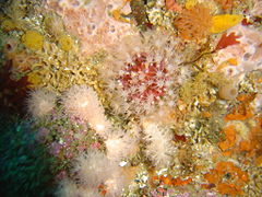 Soft corals
 Sponges and zoanthids


Features
editA few small talus caves and swimthroughs have been reported from Cowrie Caves site.
Photography
editGood site for macro photography.
Routes
editUsually a live boat dive as the reef is large and there may be a current. There are no recorded routes for any of the drop points.
Stay safe
editHazards
editCold water and light surface current is normal for this area. Strong offshore winds may develop over a short time, but forecasts are usually reliable. There are some fairly tight swimthroughs which may have strong surge flow through them, which could cause a diver to get wedged into the restriction. The risk will depend on flow strength, diver size, and equipment configuration. Ordinary caution and on-site risk assessment is appropriate.
Skills
editNo special skills required, though the ability to deploy a DSMB is strongly recommended in case you are separated from the group or need to surface away from the shot line.
Equipment
editIt is cold and moderately deep, and a dry suit is recommended. This is a dive site where the use of Nitrox can be worthwhile to extend no-stop time. A light is recommended for looking into crevices and to restore colour to the marine invertebrates. This is a large site, well offshore, and it is strongly recommended to carry a DSMB and reel and use it for surfacing, particularly if decompression stops are required, as a diver can drift quite a long way during ascent, and may not be easily visible if they drift off the site. A compass can also be useful for keeping track of directions, as there are few other clues.
Nearby
edit
- 1 Seal Island
- 2 Di’s Cracks
- 3 Vulcan Rock
- 4 Klein Tafelberg Reef
- 5 Tafelberg Deep Pinnacle
- 6 Tafelberg Deep
Back to the Alphabetical list of sites, or list of dive sites in the Outer Hout Bay area
Other regional dive sites:
- Dive sites of Table Bay and approaches
- Dive sites of the Cape Peninsula east coast
- Dive sites of False Bay offshore and approaches
- Dive sites of False Bay east coast
- Fresh water dive sites of the Cape Town Metropolitan Area