Diving at Wilhelm's Wall

The dive site Wilhelm's Wall is an offshore rocky reef in the Oude Schip headland area on the Atlantic seaboard of the Cape Peninsula, near Hout Bay in the Western Cape Province of South Africa.
Understand
edit

This is a very pretty reef, and the top of the reef is deep enough not to break in conditions that are diveable. The wall is a manageable size for a single dive, and the adjacent reef is extensive enough to make return visits worthwhile. It was discovered during the analysis of a multibeam sonar survey by Wilhelm van Zyl for the South African Council for Geoscience, and was first dived on 26 March 2017 by a group of divers on the Blue Flash charter boat Ruby Runner.
Position
editName
edit"Wilhelm's Wall" is named for the diver who identified the site from bathymetric data, reported it as an interesting possibility, produced a map from the sonar data, and was present at the first known dive at the site. The "Geoscience Gully" to the south recognises the public service research done by the Council for Geoscience, particularly its utility to the divers of Cape Town.
Depth
editMaximum depth is about 33 m, at the west end of the ridge. and the top of the ridge is about 12 m. (Average depth of a dive is likely to be about 20 to 25 m.)
Visibility
editVisibility is likely to be typical of that part of the peninsula coast. The exploratory dive had visibility of over 10 m, following a short but strong southeasterly wind.
Topography
editThe wall is mainly along the southwest and northeast sides of a fairly narrow granite gully. which blends into shallower but lower reef to the southeast. The gully is fairly flat bottomed, and the parallel ridge to the south is more broken and less consistently steep.
Geology: Precambrian granite of the Peninsula pluton.
Conditions
editThe site is exposed to wind from all directions, and swells from the northwest to southwest, so should be dived in low swells and easterly winds, and is likely to be good after a strong southeaster if the swell is reasonably low. It is likely to be good most often in summer, but can also be dived during other seasons when conditions are suitable.
This is an area which sometimes has upwellings after a strong south-easterly wind, resulting in cold, clear water for a while, then an algal bloom which will reduce surface visibility, but may leave it reasonably clear but quite dark in deeper water.
Get in
editThis site is only dived from a boat, as it is dangerously far offshore and there is no road access to the adjacent shore.
The site is about 8.5 km from the Hout Bay harbour slipway
See
editMarine life
editColourful sponges, noble corals, sea anemones,basket stars, brittlestars and other starfish on the steep rock faces, Kelp and smaller seaweeds on the top of the ridge, and sea urchins on the deeper reef top surfaces. Small shoals of hottentot seabream.
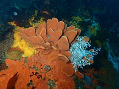 Sponge with basket star
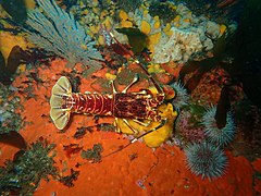 West coast rock lobster
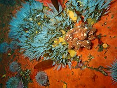 White feathery hydroids
 Brooding cushion star
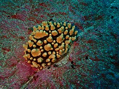 Teat sponge
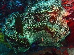 Sponge
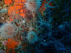 Brittlestars and urchins


Features
edit- The eponymous wall
- Some swim-throughs have been reported, but their position is not known.
 The wall face at Wilhelm's Wall

Photography
editThe topography is on a scale too large for scenic photography unless the visibility is unusually good, and there are lots of fairly small, colourful invertebrates, so macro and wide angle lenses will be most versatile most of the time. On a really good day natural light will be sufficient, but the site is deep enough that there will not be much red left in the ambient light, even on a good day, so lighting will be needed to restore colour.
Suggested routes
editDrop the shot at the coordinates given, which is against the south face, near the deep crack joining the north and south sides. Swim along the face of the wall and around to the other side, and then just explore the parts not yet reported.
Stay safe
editHazards
editNo site specific hazards reported.
Skills
editThe site is a bit deep for entry level divers, and the parts above 18m are not particularly interesting. The site is fairly easy to navigate if you stay on the wall, but if you plan to explore further, the ability to deploy a DSMB is recommended. Good buoyancy skills are also important as the rock face is near vertical over a height of up to about 15m.
Equipment
editThe water will be cold - usually below 10°C on a day with good visibility, so a dry suit is recommended though not essential. A DSB is recommended, and Nitrox will give you a longer dive.
Nearby
edit
- 1 Steps
- 2 Rachel's Reef
- 3 Humpback Ridge
- 4 MV Harvest Capella
- 5 Die Middelmas
- 6 Twin Towers
- 7 MV Keryarvor and the Jo May
- 8 SS Maori
- 9 SAS Gelderland
- 10 SS Oakburn / MV Bos 400
- 11 Die Perd
- 12 Kanobi’s Wall
- 13 SURG Pinnacles
- 14 Star Wall
- 15 Sunfish Pinnacle
Back to the Alphabetical list of sites, or list of dive sites in the Oude Schip and Leeugat area
Other regional dive sites:
- Dive sites of Table Bay and approaches
- Dive sites of the Cape Peninsula east coast
- Dive sites of False Bay offshore and approaches
- Dive sites of False Bay east coast
- Fresh water dive sites of the Cape Town Metropolitan Area