The dive site Kanobi's Wall is an offshore rocky reef in the Karbonkelberg headland area on the Atlantic seaboard of the Cape Peninsula, near Cape Town in the Western Cape province of South Africa.
Understand
edit

This is a good site for rugged topography, biodiversity and depth range.
Position
editName
editThis blinder off Duiker Point was named "Kanobi’s Wall" by Odette from Pisces Diving in 2005. It has been speculated that this may have some connection with the character Obi wan Kenobi in the Star Wars movies, but this has not been confirmed. The reef to the south was named Star Walls following this example. Kanobi's wall is also referred to as Kanobi's Reef, as the wall is not such a distinctive feature.
Depth
editMaximum depth is about 25 m, and the reef breaks the surface at one place.
Topography
editRelief above 18 m is quite spectacular. Huge stacked boulders, with tunnels, overhangs and caves of various sizes, and lots of vertical walls, some probably 10m or more in height. Deep narrow gaps and crevices. No sand seen. A knocking sound suggests a loose boulder somewhere, which is moved by the surge. There is a small cave at S34°02.358’ E018°18.103’, a low, wide cave at S34°02.347, E018°18.102’, 19 m deep, and a swim-through from S34°02.349’ E018°18.116’, 13 m deep to S34°02.358’ E018°18.125’, 13 m deep.
Geology: Granite of the late Pre-Cambrian Peninsula pluton.
Conditions
editThe site is exposed to westerly swells and wind, and also, though the fetch is relatively short, to south easterly winds and wind chop. The wind chop will not usually affect the diver when underwater, bur can make recovery by the boat relatively difficult, particularly if there is wind driven spray. South westerly swell will significantly affect diving due to surge conditions, as the site includes quite shallow areas and a number of narrow gullies and swim-throughs, which can focus and magnify the water movement to an awesome surge, and can provide some adrenalin rushes for the unwary diver. The site is usually at it's best in summer but there may also be occasional opportunities during autumn and early winter. Note that in summer the south east wind may pick up from a calm morning to strong or even gale force by afternoon. This is reasonably predictable and the weather forecast should be consulted.
This is an area which sometimes has upwellings, caused by the south easterly wind, resulting in cold, clear water, sometimes followed by a plankton bloom, which reduces the visibility again.
Keep a lookout for times when the forecast is for low short south westerly swell and light winds, as this will indicate a reasonable chance of good conditions.
Get in
editThis site can only be accessed by boat. It is about 6.9 km from Hout Bay harbour.
See
editMarine life
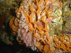
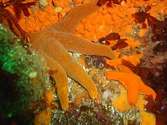
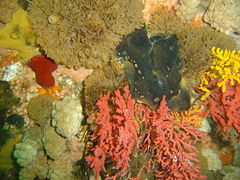
editTypical of the big reefs of the Atlantic coast. Heavy growth of red bait in shallow areas, Split-fan kelp on top surfaces of the reef in moderate depths. Walls, caves and overhangs are covered with a wide variety of sponges, corals, ascidians and other invertebrates.
- Red algae and pink ball sponges
- Red algae and pink ball sponges
- Colonial ascidians
- Pore-plated false coral and multi-coloured sea fan
- Multi-coloured sea fan on colonial ascidian
- Small basket star and sea urchins
- Two starfish
- Red klipfish on orange sponge
- Brown klipfish on bryozoan
- Octopus in crevice
- Cone shell
- Noble coral and brown sponges
- Green moon sponge
- Grey sponge and Rock crab
Features
editLarge swimthrough, at 13 m depth, as shown on the map, several deep gullies and a few small caves.
Photography
editGood site for photography if the surge is not too strong.
Routes
editDrop in near the pinnacle and swim around the rocks at various depths. Start deep and work your way up, inspecting the various zones. It is necessary to keep away from the blinder when surfacing, as the surge over the top can be dangerous to both divers and boats, so it is advisable to swim well away during the ascent, and for this reason a DSMB and compass are recommended. The swimthrough is worth a visit if the surge is not too strong.
Stay safe
editHazards
editCold water, Strong surge in gulleys and swim-throughs. Breaking waves over exposed rock. Sea urchins. Strong offshore winds may develop over a short time.
Skills
editAbility to deploy a DSMB is useful, as is ability to use a compass. Divers should be adequately skilled at buoyancy control in surge, and able to fin fairly strongly, unless the swell is exceptionally weak.
Equipment
editTake a light to see into dark places, like overhangs and swim-throughs. A compass is useful to keep track of where you are, and a DSMB is useful if you surface away from the reef, which is desirable as the waves break over the blinder. Nitrox may extend your dive time if you are well insulated.
Nearby
edit- 1 Die Middelmas
- 2 Twin Towers
- 3 MV Ker Yar Vor and the Jo May
- 4 SS Maori
- 5 SAS Gelderland
- 6 SS Oakburn / MV Bos 400
- 7 Die Perd
- 8 SURG Pinnacles
- 9 Star Wall
- 10 Sunfish Pinnacle
- 11 Canyon
- 12 Stonehenge Dusky Pinnacles - Coral Pinnacle
- 13 Stonehenge Blinder
Back to the Alphabetical list of sites, or list of dive sites in the Outer Hout Bay area
Other regional dive sites:
- Dive sites of Table Bay and approaches
- Dive sites of the Cape Peninsula east coast
- Dive sites of False Bay offshore and approaches
- Dive sites of False Bay east coast
- Fresh water dive sites of the Cape Town Metropolitan Area


