Diving at Di's Cracks

The dive site Di's Cracks is an offshore rocky reef in the outer Hout Bay area on the Atlantic seaboard of the Cape Peninsula, near Cape Town in the Western Cape province of South Africa.
Understand
edit
A spectacular dive if the visibility is good. Lots of walls and overhangs, swimthoughs and deep, wide cracks between enormous granite outcrops. The walls are heavily encrusted with marine organisms.
Position
edit- 1 Di's Cracks 14 m Pinnacle: S34°03.855’ E018°18.400’ – Very big flat topped pinnacle - boulder on top of main reef outcrop. About 300 m north west (328° magnetic) of Vulcan Rock
- 2 Di's Cracks 9 m Pinnacle: S34°03.873’ E018°18.417’ – Big pointy topped boulder jammed into the top of a crack with a big swimthrough underneath.
This site is in the Table Mountain National Park Marine Protected Area since 2004. A permit is required.
Name
edit
The site is named "Di's Cracks" for the deep cracks between the huge granite outcrops, which are wide enough to dive, and Di Froude, a local diver who discovered and popularised the site.
Depth
editMaximum depth is over 30 m. Average about 18 to 24 m. Top of shallowest pinnacle about 9 m. Most of the big cracks are between 20 and 27 m.
Visibility
editViz will usually be much the same at Vulcan Rock.
Topography
editDi's Cracks are at the northwestern end of a broken granite ridge which extends southeast via Vulcan rock, which is the highest point, and Tafelberg Reef, as far as Klein Tafelberg Reef, in the approaches to Hout Bay, where it is interrupted by sand. To the southwest is deep water, while the reef to the norteast may be continuous to Stonehenge, Duiker Island and Dungeons Reef.
The reef is made up of big granite outcrops and boulders with overhangs, a few swim-throughs, and the cracks, which are deep and wide enough for a skilled diver to keep clear of the sides.
There are several swim-throughs right under the pinnacle and among the jumble of huge boulders which form the shallow pinnacle at about S34°03.858’ E018°18.393’. The pinnacle comes up to about 9 m and the bottom to the southwest in this area is at about 30 m. Several of these swimthroughs are fairly spacious.
There is a fairly long, high, and steep wall on the north face of the site, below the 14 m pinnacle, with a few deep gullies extending southwards into the main outcrop.
Geology: Granite of the late Pre-Cambrian Peninsula pluton
Conditions
editThe site is exposed to south westerly swells, which can cause a strong surge. The site is usually at its best in summer but there are also occasional opportunities in autumn and winter.
This is an area which sometimes has upwellings, caused by strong south easterly winds, resulting in cold clear water, which may develop a plankton bloom over a few days, which will reduce the visibility again.
A surface current may be experienced, (This has been measured on one occasion at about 1 km/h setting about 170° magnetic, in light south easterly wind)
Keep a lookout for times when the south west swell is low and short period, and there is not too much south easterly wind forecast.
Get in
editThe site is only accessible by boat. It is about 5.7 km from Hout Bay harbour.
See
editMarine life
editHeavy encrustation of invertebrates on the rocks, particularly on vertical and overhanging faces.
 Dwarf spotted anemone
 Noble coral
 Nudibranch and Orange cup coral
 Nudibranch
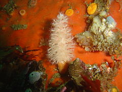 Soft coral and sponge


Features
editThe cracks: Deep, almost vertical walled gaps between the outcrops, and swimthroughs.
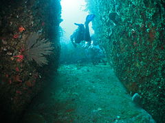 looking out from the end of a crack.
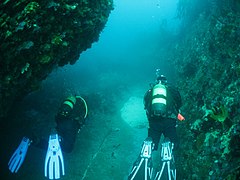 Passing the large boulder.


Photography
editA good site for macro and wide angle photography.
Routes
editMost suitable as a live-boat dive as this allows the divers to explore the area without having to find their way back to the boat.
- Di's Directions: "The easiest way to find the caves and cracks is to swim in a N / NE direction from the top of the plateau which is at 11 metres. Drop over the edge of the plateau and continue with the wall on your left side. Pass over a deep gully and you will see what I call the salad bowl below you . This is a circular bowl filled with sand and gravel in the rock on the 'floor' at the bottom of the wall. Drop into the salad bowl and you will see a huge boulder on the right hand side with an overhang. Swim under this overhang on the left side and there is a large hole which will give you access to one of the caves. There is a series of caves to swim through until you get to the main cave which leads into the crack. All the caves have exits that can easily be seen from the entrances and are easy to dive through." (these directions rely on starting from the right place, and unfortunately the start position is not available)
Stay safe
editHazards
editCold water, Strong surge in cracks and swim-throughs. Sea urchins. Strong offshore winds may develop over a short time, making it tricky to spot divers on the surface, and a wet trip back.
Skills
editGood buoyancy control, trim, and finning technique is necessary to avoid damaging the encrusting organisms on the walls.
Equipment
editThe site is cold and relatively deep, and a dry suit is recommended. This is a dive site where the use of Nitrox can be worthwhile to extend no-stop time. A surface marker buoy may be useful to show position of the group, but hinders access to overhangs and swim-throughs, and may snag on red bait at top of walls. A DSMB is recommended for the ascent and for individual divers in case of separation from the group, even if only to signal to the boat when on the surface.
Nearby
edit
Back to the Alphabetical list of sites, or list of dive sites in the Outer Hout Bay area
Other regional dive sites:
- Dive sites of Table Bay and approaches
- Dive sites of the Cape Peninsula east coast
- Dive sites of False Bay offshore and approaches
- Dive sites of False Bay east coast
- Fresh water dive sites of the Cape Town Metropolitan Area