Wikivoyage talk:Mapmaking Expedition/Archive 2003-2013
Derivative Work?
editI'm wondering if the copyright holder of an arial photograph could claim that a map made using the data in that photo as a derivative work. Can anybody out there elucidate? -- (WT-en) Mark 03:46, 5 Dec 2003 (PST)
- IANL, but I seriously doubt there would they could/would make such a claim. This is how virtually all professional map makers make their maps. They buy the arial photograph from the government and create their maps from that. They often then do very minor intentional deviations from the real situation, so that they can detect someone who copied from their map.
- Most arial photographs are created and sold by governments. In Canada, they specifically mention mapmaking as one of the main applications for purchasing aerial photographs. You do not have to purchase any special license for creating a map from an arial photograph. (You do however, if you want to include the aerial photo on your website). -- (WT-en) Webgeer 16:31, Aug 30, 2004 (EDT)
- Yeah it seems extremely unlikely that an aerial imagery company would attempt to sue someone for breach of copyright, if they traced a map of an particular town, over their images.
- I think it gets a bit more risky when you look at doing something more systematic on large scale (e.g. if you want to involve lots of people and give them explicit instructions how to create a map)
- The OpenStreetMap project provides inbuilt features of their mapping editing tools, which bring in aerial imagery for the purpose of tracing over it... but in order err on the side of caution (and because OSM is very sensitive licensing issues), they do not do this with copyrighted aerial imagery. They only use Yahoo!'s aerial imagery where they have been given special permission to do so. See this discussion. Hopefully a microsoft buy out will not affect this agreement!
- OpenAerialMap doesn't offer enough coverage to be useful yet, but that'll be the next thing!
- -- (WT-en) Harry Wood 12:14, 7 February 2008 (EST)
- The licensing looks fine for use with WT: OSM licensing Why not use them?--(WT-en) Anonperson 09:00, 8 June 2010 (EDT)
Peter's projection
editI have a question, is necessary to use Peter's projection? I received some cartography lessons, and my teacher told me that this was the only projection in the history that has some restrictive license. (And this seems not very correct in a wiki!). Besides, the goal that claims is that all regions have the same size, this is called equal area propierty, and is different from the conformal (Mercator is conformal) which keeps the shapes of the represented lands. This was known even by the old greeks, and in the 17th century there where equal area projections, so Peter's is more marketing than real discovering! I don't want to change this without hearing all opinions first, of course. If you want more easy and good information, USGS has it on the web:http://mac.usgs.gov/mac/isb/pubs/MapProjections/projections.html -- (WT-en) pstng
- Well, if the projection has a license that would make it difficult to make maps under our copyleft, I'd say of course we shouldn't use it.
- But I'm really clueless about cartography. For the kind of stylized travellers' maps that we're talking about making, does an equal-area map even factor? At what level does Peter's projection come into play? Do street maps like the one on Montreal need it? --(WT-en) Evan 10:08, 23 Dec 2003 (PST)
- I can't imagine how the Peters projection could have a restrictive license. The method is to project from the axis perpendicular to the axis onto a cylinder. This is simple mathematics and is used to derive the formula for the area of a sphere.
- An area of land less than 400 km2 can be surveyed as if it were flat. This is the area equivalent of one second of arc (to be precise, it's 391 or something like that). This is 2/7 the size of Mecklenburg County. On a map for travelers, a minute of arc is inconsequential, so the area could be 24000 km2 and shown as flat. So a street map of a city doesn't need a special map projection.
- I would not use the Peters projection except for a map of a large part of the earth where you need both equal-area and straight meridians. Far from the equator (or whatever parallel is specified), it distorts the horizontal and vertical to preserve the area. My preferred map projection is the azimuthal equal-area, which has the least overall distortion. You can make one of these 5°07'30" in radius (North Carolina is 2°36' from north to south) and have a distortion of 0.1%, which is quite good enough for a map on the Web. A Peters projection has this much distortion at latitude 2°33'45"; in a disk, it's concentrated at the north and the south. -(WT-en) phma 18:32, 23 Dec 2003 (PST)
- I agree with all, it was just a matter of using an originally (at least) patented projection. Anyway, with small areas, nobody uses it, since you can say that any map is more or less conformal and equal area at the same time.
- And the other fact is that making a map is extremly difficult if you don't have data, and this data is often under a licence. Because of that, we can only make some schema, not really a good projection, or we can take a free map from some web site.-- (WT-en) pstng 24 dec 2003
GRASS Comments
editGoing to other topic, if somebody knows how to use a GIS (Geographic Information System), there's GRASS, which is free (don't know the exact licence, but I think that is Open Source) and aviable for Windows, Linux and most of the operatng systems. The only problem is finding data, but at http://www.freegis.org/geo-data.en.html there's some public domain data, and from there is possible to make well projected maps. I know just two things about using GRASS, but if there's some GRASS user, I think that we can get good results, at least for maps with big areas. For city plans, it's really more difficult to find data (without paying, of course). What do you think? --(WT-en) pstng
- One of the short comings that I saw in GRASS was that there wasn't much for vector output. Ideally it could just do SVG. (WT-en) Yosemite 20:04, 29 Jan 2004 (EST)
- Grass is under the GNU General Public License (GPL) and it looks like SVG export is currently not supported, but therefore a lot of other vector-formats. The vector abilities of GRASS have improved a great deal with the 6.x version. (WT-en) Nicamds
US and TIGER Line Data
edit- For cities in the USA, we can use the TIGER files. I downloaded the TIGER file for some random North Carolina county; it has roads, creeks, and mills in it. They're produced by the federal government, so they're public domain. -(WT-en) phma 07:56, 24 Dec 2003 (PST)
- That's cool. So, do you have any clue how to pull this data into an actual travellers' map? Just a simplified map with just the more important streets and such? And maybe adding in on top of that some of the common map symbols for attractions, restaurants, bars, & hotels?
- I'm wondering if it'd be easier just to eyeball distances for cities without hairy countours (like a river running through the middle.) I mean, I'd say we'd want to top out the maps at about 20 streets on a map -- if it gets more detailed than that, make a smaller-area map.
- Anyways, info on sucking in contour info to an image format would be cool. --(WT-en) Evan 09:43, 24 Dec 2003 (PST)
Is it OK to eyeball coordinates from an existing map, plot them, and draw a map that way? -(WT-en) phma 18:18, 24 Jan 2004 (EST)
- Totally. Just make sure that you upload a vector-format version of the resulting image, so someone with more GIS skill than I have can correct it later.
--(WT-en) Evan 21:15, 24 Jan 2004 (EST)
- Okay. I'm about 2/3 of the way through the boundary, then I'll write the program, and upload the map in PNG, SVG, and the list of coordinates. -(WT-en) phma 07:26, 29 Jan 2004 (EST)
- Map's up. How's it look? -(WT-en) phma 21:38, 4 Feb 2004 (EST)
- Cool! The colors are a bit ... interesting. I wonder if we can have a discussion on style? Colors, line attributes, fonts, etc. -- (WT-en) Yosemite 21:54, 4 Feb 2004 (EST)
- It doesn't look like anything happened with this discussion. I think for the purposes of a consistent look, this is extremely important. I will try and come up with at least the colors. My general thought is that land should be light enough that when printed will be virtually white, while water should be dark enough that it will be dark gray gray. I will also come up with some line types/colours to be used for borders, freeways, major roads, minor roads, subway lines, stations. - (WT-en) Webgeer 22:53, Aug 26, 2004 (EDT)
For everyone's information I'm working out a program right now that can suck in the Type 1 and Type 2 TIGERLine files and generate SVG files that can then be modified in Illustrator, Sodipodi, or other. -- (WT-en) Yosemite 20:04, 29 Jan 2004 (EST)
- We have some maps. Kinda. I've generated and edited a map of downtown Reno that everyone can check out. It's still really rough. I'm currently trying to get sodipodi to bend to my will properly. One problem that I'm having is that intersections aren't lining up correctly from the TIGER data. I'll probably build another little python program that can clean up these intersection errors. Another thing that is really wrong with this map is that it is huge. I need to work out scaling and making fonts still readable. Also sodipodi doesn't seem to like that many lines on my machine (P2-350, ~256MB RAM), so editing was a little painful for me. I've tried kontour and sketch as well to work on this file, and sodipodi still works the best. I'm keeping my eyes peeled for something a bit nicer.
- So the python script is now available at http://www.dasbistro.com/~sam/maps/wikivoyage/python-tigerline . To have everything work you need the improperly named TigerRecord.py file and LatLongUTMConversion.py. Run TigerRecord.py with no arguments to see how to use it. Get TIGERLine data from the US census at http://www.census.gov/geo/www/tiger/ .
- For the modest sized Washoe County the script takes ~150MB of RAM during the startup when it loads the TIGERLine file. So watch out if you are RAM slim. There are ways around this mainly involving making the amount of TIGER data significantly less. I'm not too keen on making these changes since it's a minor pain.
- The runtime on my machine to process Washoe County took about 25mins. Most of that is reading in the TIGER records.
- Some things that I want to work out in the script are:
- splitting out the modules properly (which was originally my intention)
- getting a graphical scale on it,
- possibly more intelligent placement of street names
- actually using SVG DOM or just regular DOM
- maybe using the proper origin for the map
- I'm going to be doing a map of the Tenderloin next. I'll hopefully work out some more kinks by then. Either post here or send me email if you folks have questions. -- (WT-en) Yosemite 05:11, 9 Feb 2004 (EST)
- I'm going to try checking this out. I made a page called Project:Software tools, which might be a little general for map-making tools. Anyways, it might be useful to list y'all's map tools there.
Latitude/Longitude Coordinate Representation
editI'm thinking of using this format for coordinates:
- 12.34 means 12 degrees and 34 hundredths of degrees
- 12.34. means 12 degrees and 34 minutes
- 12.34.56 means 12 degrees, 34.56 minutes
- 12.34.56. means 12 degrees, 34 minutes, 56 seconds
A single letter N, E, W, or S indicates which coordinate it is. Does this make sense? -(WT-en) phma 10:34, 2 Feb 2004 (EST)
- This makes sense to me, but what are you trying to acheive here? Where are we going to be using these coordinates? Personally I think sticking with one uniform system would be best. For example: [+-]DDDMMSS (Degree/Minute/Second, with the sign indicating E/W N/S) or something like [+-]DDD.FFFF... (Degree/Fractional Degree.)
- My main criticism is that the trailing dot in your notation could be error prone (in input or from editing.) And sticking with a straight forward no deviations standard might be the way to go. Of course I should rule the world. -- (WT-en) Yosemite 21:28, 2 Feb 2004 (EST)
- This is for the input to my program; an example is Image:NorthCarolina.dat, which I have since edited (adding "scale" and "center" commands and the trailing dots) and will reupload when the map is ready. The format is for hand-entered coordinate files that don't need the full complexity of, for instance, the TIGER file format. The alternative is to have a "format" command that tells how many times you take two digits and divide by sixty. I don't like using + and - (though the program does internally) because it's too easy to forget which is east and west and get a mirror-reversed map or get the latitude and longitude confused.
- The output will be SVG. It is currently a list of coordinates in millimeters.
- No deviations standard? No distributions normal, either? :) -(WT-en) phma 00:20, 3 Feb 2004 (EST)
- Oh crazy. Nevermind my comments. I look forward to seeing the fruits of your labor. Your "language" reminds me a lot of Postscript. I have most of a TIGERLine to SVG converter worked out (for City/Region maps.) Most of it was messing around with python and discovering the joys of UTM. I expect to have the it in a "usable" state later in the week. By usable I mean that should be able to have some files that I can manipulate in Sodipodi that have streets on them. I still need to work out polygons(lakes) and possibly rivers. -- (WT-en) Yosemite 01:47, 3 Feb 2004 (EST)
Source of data
editI have an old atlas (Diercke Schul-Atlas für Höhere Lehranstalten of 1907) which I plan to scan for Wikipedia. I licence everything under both GFDL and CCSA, so if necessary, it can be used for Wikivoyage as well. Below are links to a few scans (I can make a PNG if needed). I don't know if they are of any use, however.
- http://fr.wikipedia.org/wiki/Image:Europe_geologique.png
- http://fr.wikipedia.org/wiki/Image:Europe_geographique.jpg (small)
- http://fr.wikipedia.org/wiki/Image:Europe_geographique_grande.jpg (big)
- http://fr.wikipedia.org/wiki/Image:Suisse_geographique_petite.jpg
- http://fr.wikipedia.org/wiki/Image:Alpes_petite.jpg (small)
- http://fr.wikipedia.org/wiki/Image:Alpes.jpg (big)
(WT-en) Yann 07:22, 10 Feb 2004 (EST)
- They are beautiful maps, but I'm wondering how they fit in with travel? Most of the maps that we are planning on having are geared towards helping someone navigate foreign places and plan for trips. I'm wondering how you see these maps fitting in the site with that in mind. -- (WT-en) Yosemite 03:27, 11 Feb 2004 (EST)
- Well, first I understood that we want SVG maps, so these can be used as they are. But maybe they are useful to draw SVG maps? That's what I understood from the discussion above. I don't know anything about SVG through. (WT-en) Yann 04:53, 11 Feb 2004 (EST)
- Oh, ok. Yes that is much more useful. I just wasn't sure how you were seeing these maps fit into the site. I'm jotting notes on making maps to add some more meat to the expedition that includes digitizing existing maps. -- (WT-en) Yosemite 16:36, 11 Feb 2004 (EST)
City Map Markup Language
editUser:(WT-en) Blackisha has written up an initial proposal for a (WT-en) Map Making Markup for WikiTravel maps.
Distance tables
editIs there any interest in setting up distance tables? For instance a Distance table for Europe? I don't know if there are any public domain (or CC BY-SA or CC BY) sources that could be used for this... (WT-en) Guaka 11:18, 26 Mar 2004 (EST)
Copyrights
editIt seems like a map would have copyrights, but the page on Mapmaking expedition said that most do not have one. If someone could explain this it would be helpful. (WT-en) mrtrey99
- Trey, I am not a lawyer, but as I understand it maps are in general copyrightable. You should assume that they are copyrighted unless otherwise specified.
- I think you may have misread the description of the Perry-Castaneda Collection at the U of T. It said "Most maps are public domain", meaning that most maps in that collection are public domain. I've changed the description to be more clear. --(WT-en) Evan 14:28, 28 Apr 2004 (EDT)
I know the person who did hundreds of region maps for Wikipedia. I can ask her if she'd be interested in dual licensing them if we'd like to use them. (WT-en) Caroline 22:18, 27 Jul 2004 (EDT)
Fair Use (part of US copyright law)
edit"Fair use" forbids damaging the original work's sales in the marketplace. So we need to label clearly any stuff we have on the site that is here by virtue of fair use and thus cannot be used commercially in a way that would damage the original work's sales in the marketplace. Wikipedia has this problem, too.
- US Copyright Office on "fair use" -> http://www.copyright.gov/fls/fl102.html
- Just because US law says we can does not mean we need to choose to do this. Project:Copyright details sets out the standard for Wikivoyage. It says fair use is not appropriate for Wikivoyage. Because Wikivoyage uses a different copyright licence what may be acceptable for Wikipedia may not be suitable for Wikivoyage. -- (WT-en) Huttite 21:02, 29 Dec 2005 (EST)
- Having looked at the Fair Use section, (Section 107), it state that Fair Use is permitted for purposes such as criticism, comment, news reporting, teaching ... , scholarship, or research. Travel is not on the list. While Wikipedia may be considered a work of scholarship or research, because of the standards they set about researching articles, it is highly unlikely that Wikivoyage could claim the same thing. It is difficult to see what of the above Fair Use criteria articles written for Wikivoyage would even fall under - even news reporting is a bit too much of a stretch. It seems to me that the Fair Use provision exists to allow somebody to comment or respond to what somebody else has said, either to contrast or support an agument or as evidence in an opinion piece. This is not the main intent of Wikivoyage. Consequently, I cannot see how the provisions of Fair Use would apply to Wikivoyage content - it might to talk pages and how I used it here is a classic example of Fair Use; including criticism, comment, and teaching. Unless you use copyrighted works in a similar way it is not Fair Use. -- (WT-en) Huttite 06:36, 31 Dec 2005 (EST)
- "Fair use", or the corresponding terms in other legal systems, is much more general than that. The list after "such as ..." are only examples. There's a good FAQ at [1].
- We could even quote another guide, or other references. Something like: Guiness rates Back-of-beyond-istan the coldest country on Earth and Other Guide claims "between the climate, the appalling sanitation, and the gunfire, B-o-B-istan should be avoided at all costs." However, ... (WT-en) Pashley 01:30, 9 March 2009 (EDT)
- That is, copyright protects against copying a work, but it does not restrict quoting. In the example above, we could legitimately use a brief quote from Other Guide in order to comment on it. Of course, if we copied a whole article, then that would be a copyright violation. But the question of copyright should not even arise for a short quote; it is fair use, end of story.
- In between, it is hard to tell. What if we quote a few sentences? A paragraph? A few paragraphs? Whether those would be fair use depends on several things; only a judge could decide and the answer might be different in different countries. For such things, I'd say WT policy should be to avoid them. If in doubt, do not use the quote. (WT-en) Pashley 20:52, 11 March 2009 (EDT)
- As far as I'm aware, everyone involved here in mapmaking only uses PD and ccbysa sources for their maps... fair use isn't in practice here, and I don't think there are plans to start – (WT-en) cacahuate talk 23:59, 11 March 2009 (EDT)
Digital Millennium Copyright Act (DMCA)
editUS Title 17, section 102
The Copyright Law of the United States of America and Related Laws Contained in Title 17 of the United States Code, section 102, says:
- ..(b) In no case does copyright protection for an original work of authorship extend to any idea, procedure, process, system, method of operation, concept, principle, or discovery, regardless of the form in which it is described, explained, illustrated, or embodied in such work.
- Yep! Most copyright laws distinguish between the work of art, the expression of the information about the facts if you will, from the information about the facts. Expression is copyrightable, facts are not. It is like patenting a drug. You can patent the making of a drug, not the individual atoms that make the drug. And if you find a completely different way to make the drug then you can patent that way too. -- (WT-en) Huttite 21:07, 29 Dec 2005 (EST)
Globalization and map copyright law
editWikivoyage Contributors
editThe countries where a contributor has legal ties -- lives, has citizenship or owns assets -- have meaningful legal powers over that person. Contributors beware -- know the law of your land.
Wikivoyage Server Computers
editThe countries where Wikivoyage has servers has legal powers over those servers. Someone please find out what Canadian law on map copyrights is and post it here with authoritative references (are our servers in Canada? It matters).
Wikivoyage Readers
editThe countries that allow access to Wikivoyage have legal powers over that access. China for example makes its own laws about and tries to controll what is available on the Internet in China.
Per Country Laws
editWhat works? How are maps legally made in your country?
- I know in New Zealand that Land Information New Zealand, which has done/inherited most of the surveying of the country, holds copyright over all its maps. You can assume that pretty much any New Zealand map, except the one drawn by Captain Cook, is copyright to them or has a distribution licence issued by them. The aerial photographs that a lot of the maps are drawn from are also copyright, so unless you base your map on a NASA picture there will be issues with copying NZ maps. NZ copyright law is very strict and potentially mean anyone involved in the unauthorised distribution of a protected work can be sued for royalties. This could mean anyone viewing the Wikivoyage website, though it would probably stop at the Website User(s) or administrators who let it happen. -- (WT-en) Huttite 21:24, 29 Dec 2005 (EST)
Is US Copyright Law Applicable?
editIs US Copyright Law Applicable in the case of Wikivoyage, or any website? While US copyright law may be applicable to US citizens operating a US based website in the USA, does it apply to other countries?
As I understand it the Wikivoyage server is based in Canada, operating on equipment provided by a Canadian ISP, billed and paid for in Canadian dollars. It is beginning to look like the Copyright laws of Canada apply.
However, copyright law is more complex than that. A recent Austrailian court ruling apparently determined that the act of publication of material published on a website occurs at the place where the publication is viewed. That is on the viewer's computer, in the country that they are residing! And the local laws of that country apply. So unless Wikivoyage has copyright policies that will fit a wide range of international legal circumstances we should not rely on United States Copyright Law, which is pretty lax compared to some other countries. -- (WT-en) Huttite 19:26, 29 Dec 2005 (EST)
See also
editSVG/PNG Tools
editI'm looking to produce some maps for some Wikivoyage articles, but I'm a bit put off by the formats selected, which are not ones I'm (yet) familiar with. I was wondering whether there is any feedback on the usability of tools for these formats, in the Wikivoyage context, yet?.
Trawling the web, it seems that the only editors available are a commercial tool from JASC called WebDraw, which looks a bit expensive, or Sodopodi, which doesn't appear to run on the Win2K platform I'm stuck with. Anybody know a decent SVG editor that is (a) free and (b) runs on Win2k?.
And can anybody point me at the uploaded SVG version of a map on Wikivoyage, that I can copy and play with to gain some experience.
Thanks -- (WT-en) Chris j wood 20:25, 5 Aug 2004 (EDT)
- So, off the top of my head, Image:Central_montreal_map.svg is an example SVG map on Wikivoyage. I believe North Carolina and Reno both have SVG maps available.
- As for tools, you can check the list of SVG editors on w3.org. --(WT-en) Evan 00:07, 6 Aug 2004 (EDT)
OpenStreetMap has just added a new feature; the 'export' tab which will create an SVG map of the area you export.
Simply go to the main map display (http://www.openstreetmap.org/) find a small area to export. Click the 'export' tag. Select 'Mapnik image' and 'SVG' Format. Click 'export' and save your SVG file! Exports can be used under their open license.
-- (WT-en) Harry Wood 04:48, 26 April 2008 (EDT)
Future Wider Scope
editWhere are we heading with these ideas? Some of these discussions are setting my imagination going. In particular the idea of working with lattitude/logitude coordinates, and the map making markup idea. It seems to me the ideas have much wider scope.
In the future I imagine these efforts will evolve into a new project. A wiki-atlas. A system where rich geographical information can be built up in layers, and contributed/edited wiki-sytle, with online vector based editing tools.
I imagine the system would allow layers of information such as tourist attractions, bars, restaurants, roads, etc, and other layers of information about things like house prices, crime & polution levels, which can be displayed/hidden. A rich variety of geographical information. Different levels of detail would be presented at different zoom levels, potentially down to the exact location of a telephone box in relation to the curb on the edge of the road. I think such systems exist, but the challenge would be to apply wiki principles to the software, to make it sufficiently simple and addictive so that thousands of people obsessively map out their neighbourhood in detail, resulting in the kind of collective acheivement we see at wikipedia.org
Maybe this will rouse some enthusiasm for this kind of project, but actually I guess I want to make the point that the potential scope of this thing is big, too big, and so to make progress we need to be careful not bite off more than we can chew.
The short term goals need to be clear. We want to make it easier for wikivoyage contributors to make little maps on individual pages of wikivoyage, and we want improve the quality consistency and general usefulness of those maps. Within that limited scope there's plenty of work to be done, software to be developed, standards to be defined. ...but there's no harm in keeping one eye on the future :-) (WT-en) Nojer2 07:19, 2 Dec 2004 (EST)
- With an eye on the not too distant future, maybe the maps can be in a format and style to be acceptable to GPS applications which are becoming affordable and popular. I'm not saying that travellers should just be able to load them straight into a GPS device, but perhaps WikiTravel can adopt a format where they are usable without enormous effort. Did I make myself clear there? Oh, and its worth mentioning I have no knowledge of GPS so apologies if any graphic is usable. It may also be an idea to keep an eye on the many public domain GPS initiatives to see if maps become available. --(WT-en) Richard 2005 Jan 17
Listings on destination maps
editI'd like to solicit opinions about a choice between two different ways of connecting numbered icons on a map with Wikivoyage article listings (as in Sleep, Eat etc.) I've tried making these listings two different ways.
In the first case I add the necessary sections for listings to the Image page of the image in question and then convert the listings from the destination article to a numbered list, which are then placed on the map with numbered icons. See Paris/1st arrondissement for an example.
In the second case I've made a box containing the list of names per section from the article. See Paris/5th arrondissement for an example of a map done this way.
There are pros and cons that I can think of for each way of doing this.
Listings on the image page
editPros:
- Makes it easy to print the image and the page which goes with it
- Is slightly easier to do
- Makes it easier for somebody to correct my spelling mistakes (if any)
Cons:
- Separates the task of making the icons from the task of making the listings, introducing a possibility of errors.
- Might possibly be more difficult for travelers to understand.
Listings in a box on the map
editPros:
- Keeps the task of making the listings together with making the icons.
- Is obvious, and easy for the traveler to read.
- Allows for better graphic design.
Cons:
- Makes the png image sizes larger
- Makes it harder for other Wikivoyageers to make corrections in spelling etc.
I'm sure that there are more good and bad aspects to each way of doing this. I'd like to know what they are if possible, as I'd like to pick a method and make its use consistent.
Thanks!
-- (WT-en) Mark 08:31, 8 Dec 2004 (EST)
- I'd go for listings built into the map itself. It's better for the traveller, which is the ultimate aim, and the increased difficulty of editing is a moot point because it's already more difficult to edit a map than text. (WT-en) Jpatokal 10:26, 8 Dec 2004 (EST)
- Thanks for the feedback! -- (WT-en) Mark 11:15, 8 Dec 2004 (EST)
- Hi Mark. Thanks for asking for my opinion on this matter. (Thanks also for all your hard work on creating these fantastic maps in the first place - one of these days I must get you to tell me how you do it - software, etc..... Would like to try my hand at it for some other cities....) On the whole, given the current data, I tend to agree with (WT-en) Jpatokal, supporting listings built into the map itself, for the reasons as supplied.... The difficulty, of course, is going to be how to keep the maps updated as new entries are made under the various sub-headings..... But I guess we'll cross that bridge when we come to it! A very worthwhile experiment.... (I wonder whether we shouldn't put the listings in a separate column running down the side of the map, rather than in a box on top of the map.....? This might allow for more expansion without obscuring detail / context.... Just an idea! Also, should venues be listed alphabetically in the interests of fairness?) (WT-en) Pjamescowie 17:24, 8 Dec 2004 (EST)
- Hi Paul. I use Sodipodi to make these maps, mostly by hand. Actually I trace the outlines of the very major intersections from an aerial photo, and then fill in the rest mainly by eye from consulting a collection of maps (I don't trace from them out of concern that that might be a copyright violation). I guess I'll start a page at Image talk:Paris.svg. Maybe it will become the convention for wikivoyage maps, if enough people like these maps.
- Anyhow, I think that a box running down the side makes sense for some arrondissements, but for the 6th for example there's a huge section of the 7th which will wind up getting included on the png, and since the 7th will have it's own png my inclination is to put the listings box there.
- As for making the listings alphabetical, I suppose we could, but what I've been doing so far is duplicating the order from the article, to make it easier for travellers to refer between the map and the article. -- (WT-en) Mark 05:09, 9 Dec 2004 (EST)
- So I re-made the png image for the 1st with the new listings format and when I look at it it looks really crowded. I think with the 1st I'm going to take your advice and put the box down the left side next time. -- (WT-en) Mark 01:14, 10 Dec 2004 (EST)
- I would prefer to see a 'clean' map without the boxes. A map's primary purpose is for navigation, and I would hate to get lost under one of the boxes! I accept what you say about so called redundant areas of map which can be used for the boxes (parts of the 7th on the map of the 6th) but a map needs entry and exit routes. With regard to editing content, isn't it unWikiWiki to make it so hard (requiring graphic editor skills and s/w)? Also consider the simple case where an establishment changes it's name. If I was to contemplate how I would use the map, I would have it and a paper copy of the location page (not the image page), wouldn't most people? My ideal would be the nice icons on the map cross-linked to See, Do, Eat etc. Also see above where I have suggested they be in a format suitable for GPS devices. Thanks for the opportunity to comment, what you have done is really impressive, and if I go to Paris, your work will be with me. --(WT-en) Richard 2005 Jan 17
"Open Maps?"
edit[Moved from Travellers' pub by (WT-en) Hypatia 18:14, 16 Dec 2004 (EST)]
There's an article on Slashdot about Open Maps. Considering this is one of our big problems on Wikivoyage, I think it makes interesting reading. --(WT-en) Evan 18:59, 29 May 2004 (EDT)
Great source of maps
edit[Moved from Travellers' pub by (WT-en) Hypatia 18:42, 16 Dec 2004 (EST)]
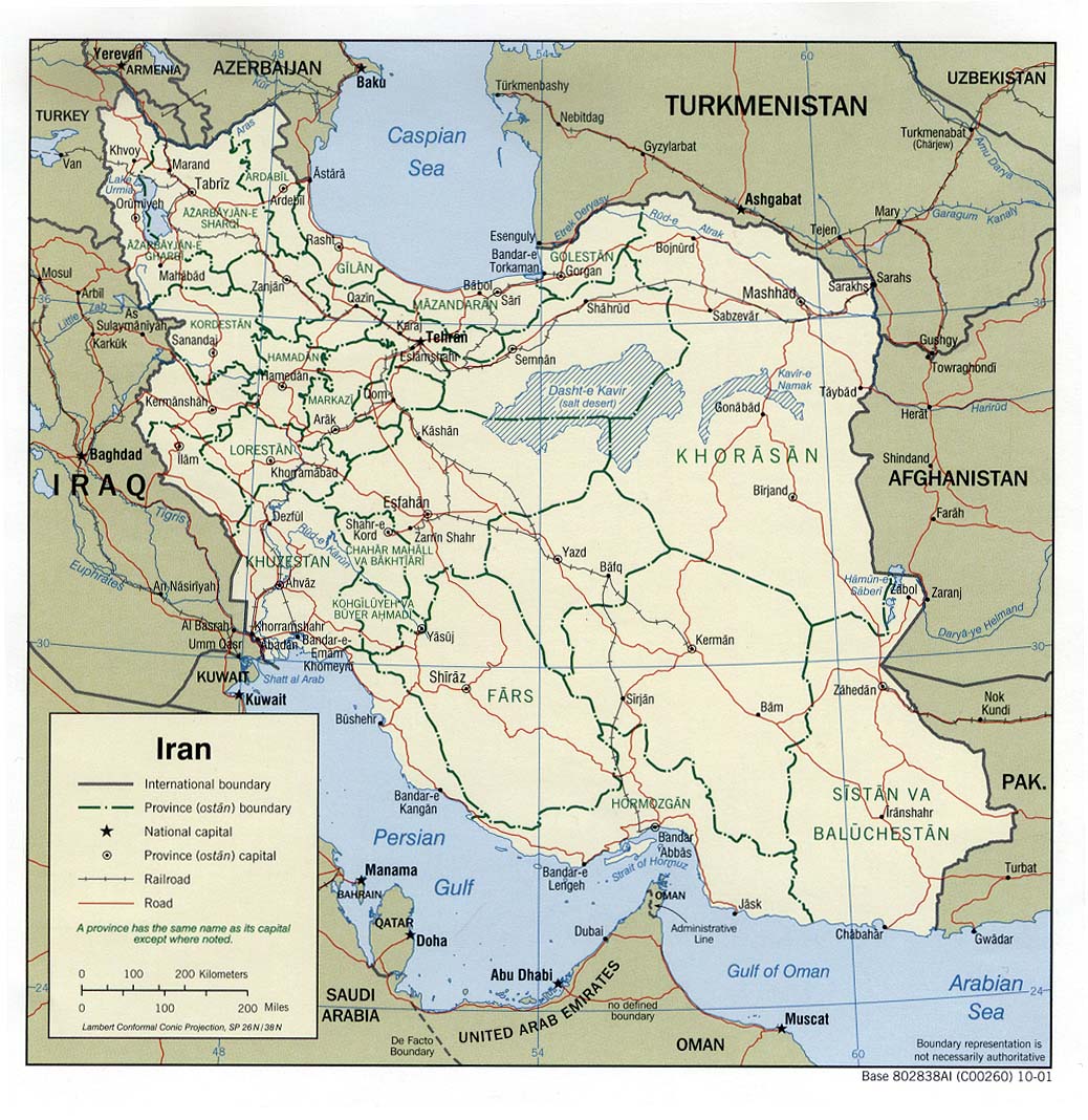
I just wanted to point everyone's attention to the University of Texas Library's map collection. They have a huge collection of maps, that according to the FAQ are in the public domain. (Maps that are still copyrighted are marked accordingly). Although the collection includes some of the CIA maps we already include on WikiTravel, they also have other maps that include province borders, major roads and railway links (e.g. for Iran) as well as maps showing ethnic, political and industrial information. These are a definite improvement on the maps we have now.
(WT-en) Allyak 09:56, Nov 3, 2004 (EST)
- They are good and better than most of our maps, but they are in JPG and GIF format, not Wikivoyage std PNG. So I thing we can provide an external link to that map page ~ (WT-en) Bijee 12:10, 3 Nov 2004 (EST)
- We have links to that collection in the Project:Mapmaking Expedition, q.v. --(WT-en) Evan 13:36, 3 Nov 2004 (EST)
- Regarding the GIF maps, these can be simply resaved as PNG and then uploaded without any loss in quality or considerable increase in filesize. JPEG maps are a different story, though. Some maps (such as topographical maps) have the colour depth of photos and therefore lend themselves to JPEG compression. It seems a shame to only link to these maps, rather than use them inline on the site, simply because the image isn't in the WikiTravel standard format for maps. Saving the maps as PNG or JPEG is simple a matter of which format compresses better. Although PNG's GIF-like compression method usually works better with maps because of their reduced colour depth, many of the Univ of Texas JPEG maps compress better in their native format. -- (WT-en) Allyak 14:40, Nov 10, 2004 (EST)
Amazing online map service: DEMIS
edit[[Image:Iriomote.png|thumb|350px|Map of [[Iriomote]]]]
Just stumbled on DEMIS today and was blown away: this is an excellent resource! Just wanted to get a second opinion on the license though:
- With this statement DEMIS BV grants you permission to freely copy the PNG images returned by our server and use them for your own purposes, including web pages. We would appreciate a reference to our server but such a reference is not required, nor do we take responsibility for the accuracy or quality of the maps.
This means basically public domain, right? "Freely copy for your own purposes", with no limitations on said purposes... (WT-en) Jpatokal 11:28, 4 Apr 2005 (EDT)
- Looks like they're using data from the world Basemap, which is public domain, yes. You can get the same data in shapefile format (for easy SVG conversion) from esri. -- (WT-en) Mark 11:53, 4 Apr 2005 (EDT)
- Data in public domain doesn't mean that the rendering of said data is in public domain, but DEMIS appears to make even their maps PD... (WT-en) Jpatokal 11:58, 4 Apr 2005 (EDT)
- Yes, you're absolutely right. I just thought you might like to know where to find the World Basemap source data. -- (WT-en) Mark 12:32, 4 Apr 2005 (EDT)
- Whoo! Just look that Iriomote map I just created in about 5 minutes, just by slapping dots and labels on a DENIS rendering. Although the subject being a near-uninhabited tropical island helps... (WT-en) Jpatokal 11:50, 30 Apr 2005 (EDT)
It's no longer Public Domain! - anon - 21:08, 17 Dec 2005
- Hmmm. The statement (WT-en) Jpatokal quoted above. Whereabouts on the website was that? Is it still there? I'll ask them. Obviously they're looking to make money from their merged datasets and their map server software, but we just want to grab images. -- (WT-en) Nojer2 06:43, 18 Dec 2005 (EST)
- Yeah we're still allowed to grab images generated by the demo map server as public domain. This disclaimer appears at the very bottom of this page.
- I think this looks like a great starting point for creating more zoomed out maps of countries etc. The feature "Support for grid based GIS layers, including interpolation, contouring, relief shading" is presumably what makes these maps look so good. Not so useful for city street maps though -- (WT-en) Nojer2 05:16, 19 Dec 2005 (EST)
- Interesting... I had a look at part of my country and immediately spotted several errors, like wrong names for places, a main highway misplotted and a railway line with a missing/misplotted section. You could use them, but for anything more detailed than country outlines and general topography, I would be very wary about accuracy. -- 21:48, 29 Dec 2005 (EST)
I noticed this map of Switzerland on the german wikivoyage which is derived from DEMIS. Seems to have nice antialiased river renderings though. I wonder how this was achieved.
Also how widespread the use of DEMIS maps is on here now? Is there an easy way to get a feel for that?
I've started using it a little on kayakwiki in conjunction with an imagemap extension to create clickable maps like this one of Europe. Other suggestions for that are welcome. -- (WT-en) Harry Wood 10:09, 18 December 2006 (EST)
SVG Uploads
editThe official policy for maps is that the SVG source file should also be uploaded, but with the current Wikimedia software it seems that there is no way for someone to then download that source. Am I missing something? Is there somewhere else that the SVG files can be uploaded to? -- (WT-en) Wrh2 17:31, 26 Jul 2005 (EDT)
- The upload works, but downloading doesn't. I'll see if I can come up with a patch. -- (WT-en) Mark
- I found out how to download them. Go to (for example) Image:Train.svg and click on the most recent date at the bottom of the page. That seems to provide the actual SVG source file. -- (WT-en) Owl 15:56, 16 Aug 2005 (EDT)
How do I...?
editI would really love to make a map of Manchester city centre, but I don't even know where to start.
Should I teach myself Inkscape, or is there another tool available for GNU that would be less painful?
Am I permitted to trace over the top of a Google satellite image? The layout of the streets is hardly copyright Google, but is there some strange loophole in the law that would allow them to prosecute for this?
Could someone post a three or four step Complete Idiots' Guide (tm) to making a map?
-- (WT-en) Owl 16:07, 12 Aug 2005 (EDT)
- The whole point of this expedition is to figure that out, actually! I made a really silly map for Montreal, and Mark's done some great stuff for Paris. There are some other city maps around. It might be good to try to figure out how to do them. --(WT-en) Evan 17:10, 12 Aug 2005 (EDT)
- I have a reasonable idea, but I was hoping for some hints! I can try tracing Google satellite imagery in Inkscape, and I've had a bit of a go at that, but I'm concerned about the legality of doing that, and I was wondering if you or Mark or anyone else has had any success stories with particular tools or techniques. I thought that was what community was for! :) I think we're a long way from the expedition's goal, but I need some help now or I'll never get off the ground. -- (WT-en) Owl 17:34, 12 Aug 2005 (EDT)
- I'm now writing Project:How to draw a map based on Mark's hints and my own painful experiences at learning. It's actually surprisingly easy, if timeconsuming when you're a clueless newbie... (WT-en) Jpatokal 06:30, 1 Jan 2006 (EST)
- I wonder whether creating a street map basing on satellite images providied by, let say, Google Maps, conforms with licensing requirements of GMaps and Wikivoyage. For example, isn't there any copyright in making a satellite image of the city? Don't you base your work upon the images when you merely pinpoint specific streets already shown on the satellite photos (even if not processed)? Any educated opinion on the subject? --(WT-en) DenisYurkin 06:21, 12 November 2006 (EST)
- I found a discussion exactly covering the subject, but giving no good answer unfortunately. If you have something to add, better do it in that thread. --(WT-en) DenisYurkin 06:47, 12 November 2006 (EST)
- Regarding Manchester, the folks at openstreetmap.org mades some good progress mapping Manchester. They actually organised an event called 'Mapchester' and had lots of people running around with GPS units to create a map which is not derived from ordenance survey. This is still a work in progress though. The maps there are all open licensed CC-sa2 -- (WT-en) Nojer2 08:15, 7 June 2006 (EDT)
- Beyond Manchester, there are several more regions covered by OpenStreetMap.org. Not really many, but worth checking for the city you consider creating a map for. --(WT-en) DenisYurkin 06:21, 12 November 2006 (EST)
Potential Map ideas...
editSwept in from the Project:Travelers' pub:
If you aren't aware already, google has had a map service for a while now (maps.google.com). And it's not half bad (only problem is that it only has US and UK... so far). Even more exciting is that they've released a javascript api: http://www.google.com/apis/maps/. I've already seen a few hacks and they look very promising. Maybe someone with more technical experience could look into it. It looks like something to potentially add to the mapmaking expedition. --(WT-en) Comrade009 14:23, 30 Jun 2005 (EDT)
- (Rude outsiders interjection) - Just thought you might like to know that we've just quietly launched Placeopedia.com, a site for easily connecting Wikipedia articles to places. Tourism and local history are the two main aims of this, and I just wanted to let you Travellers know that it's out there.
- But we cannot use Google maps on Wikitral. Planiglobe seems more promising. They are CC-by-sa-2.5. So close :-( --(WT-en) elgaard 15:27, 30 Jun 2005 (EDT)
- Are there any legal experts on this? Seems to me that having to worry about license versions is rather counter to the goal of the cc licenses. Does "share alike" imply shared using the exact same licence, or using a license which protects the same rights. Not being a legal expert, but having had it drilled into me that legal systems which derive from britain (including the US) all use the principle of what the "reasonable man" would do, and at least to me, it seems perfectly reasonable to interchange license versions which protect the exact same rights.
- This seems to put all sorts of things that people may be more than happy to share with us out of our reach unless we can reach the copyright holder directly. Case in point that I've recently become aware of is if we want to borrow some photos from flickr. People there have the option of choosing one (or none) of several cc licenses for their works, but the cc-by-sa is 2.0, and to do anything different would require adding something to the comments of every photo, instead of just setting a default rule. --(WT-en) Neil 07:08, 6 Jul 2005 (EDT)
- Yes, there are lots of things we can't include unless we get copyright holder permission. Fortunately, there are hundreds of thousands of travelers out there with ideas, photos, and energy to make this project work. We don't need to leech from those who don't want to share with us.
- As for the licenses: I'd like to get an expedition in motion to upgrade our license version. However, I think the 3.0 licenses will be more worth the trouble. Maybe we should start a Project:License Upgrade Expedition? --(WT-en) Evan 08:35, 6 Jul 2005 (EDT)
- We don't need to leech from those who don't want to share with us. My point wasn't about people who don't want to share with us, just about people who want their material to be shared (hence using a by-sa license), but who didn't initially and specifically put their material on wikivoyage. Upgrading the license seems like a good idea if it's feasible, but doesn't that require contacting every single contibuter?...at that, do they have to specifically agree, or simply not reply back to say no? And how do anonymous contributions fit into that?--(WT-en) Neil 15:10, 6 Jul 2005 (EDT)
- I agree that it's going to be hard to upgrade the license. The big problem is that the 1.0 CC license suite didn't have an "or any later license" clause; 2.0 and later do. So if we get bumped up to 2.5 or 3.0 or whatever, we can "automatically" upgrade later. As for how it has to be done: I've got some ideas, but, yes, we do need the consent of contributors. As for including stuff under other licenses: I think that's gonna be hard. Possible, but hard. --(WT-en) Evan 16:19, 6 Jul 2005 (EDT)
- It would be great to go to CC 2.X. Please put your ideas on Project:License Upgrade Expedition --(WT-en) elgaard 19:43, 6 Jul 2005 (EDT)
- I agree that it's going to be hard to upgrade the license. The big problem is that the 1.0 CC license suite didn't have an "or any later license" clause; 2.0 and later do. So if we get bumped up to 2.5 or 3.0 or whatever, we can "automatically" upgrade later. As for how it has to be done: I've got some ideas, but, yes, we do need the consent of contributors. As for including stuff under other licenses: I think that's gonna be hard. Possible, but hard. --(WT-en) Evan 16:19, 6 Jul 2005 (EDT)
- Going back to the original point. I guess technically it's easy enough to embed google maps into the wikivoyage articles. I stumbled upon this at canoepolo.org, but I guess there must be a few other wikis doing this. Here the page wiki markup looks like this: "<Map>38.521|-8.8569|0|300|300|http://www.ccsetubal.org/setubalcup/setubalcup.htm%7CSetúbal Cup 2005|</Map>"
- The slightly different idea appearing on Placeopedia.com, is to have one map, with the little markers showing the location of all the articles on the wiki. Here's a Mediawiki extension which would allow us to create such a map, if we geotagged all our articles with the wiki markup like this: "<geo>41.50725 N 81.60831 W</geo>". That idea doesn't give us copyright issues, since we just need to make it clear that this one map display page is not available under the same license. Geotags would also allow us to simply link into google maps (bit like the way we link to wikipedia) But what this wouldn't give us, is Attribution-ShareAlike maps appearing on the article pages, which is the goal of this expedition. -- (WT-en) Nojer2 16:47, 24 Oct 2005 (EDT)
- The Free part of "Free Travel Guide" is not optional. We are trying to make a travel guide which you can re-distrubute. If we rely on non-free Google maps then we are failing in that goal. I'd rather we not use them out of risk that we might come to rely on them.
- Also it's really easy to make our own maps for the US at least using Tigerline data, just like the people who supplied data to Google started with. See the map for Carbondale. -- (WT-en) Mark 17:08, 24 Oct 2005 (EDT)
- Yeah I completely agree that free maps is the way we want to go. It becomes far more useful if maps are appearing (and printable) on the article pages, and I'm sure a lot of people will find other interesting uses for the maps, if they are available as Attribution-ShareAlike. A very valuable free resource. But surely it's not "really easy" to create these maps. I mean it involves a fair amount of effort, playing around with graphics software to get half decent results.
- Linking to some coordinates on another website. Now that is really easy, which makes it tempting as a half-way solution. We could quite quickly do this for every article on wikivoyage (e.g. a small 'google maps' hyperlink in the bottom left panel). Compare that with the effort of creating a new map graphic on every article.
- But I guess what you're saying is we should resist this temptation, because we would come to rely on these external mapping sites, and the incentive to create free maps would be gone. -- (WT-en) Nojer2 06:31, 25 Oct 2005 (EDT)
DEMIS is no longer free!
editSo it has to get off the list of public domain maps. Forsome reason it didn;t let me change it on the page...212.116.172.178 16:03, 17 Dec 2005 (EST)
- I suspect you are mistaken.
- What makes you say that? It's never been free to buy the software and raw dataset from DEMIS, but images are available without copyright, as has already been discussed above. I put the question to them directly and the website still carries a notice at the very bottom of this page. So unless you have some new information... -- (WT-en) Harry Wood 10:28, 20 December 2007 (EST)
Some things I found
edit212.116.172.181 09:00, 29 Dec 2005 (EST)
Resources for maps
editSwept in from the Pub:
According to the developing "rating" system, one of the things that distinguishes a "Star" article from a merely "Guide"-quality one is the inclusion of maps useful to the traveler. Fair enough, but many of us who can and do provide text content for places are not necessarily aware of the resources for generating insertable maps. Can someone provide some pointers to resources for doing that, short of drafting the maps oneself (not practical for many destinations)? This probably should be an FAQ if there is to be pressure to include maps from here on. -- (WT-en) Bill-on-the-Hill 12:11, 18 Nov 2005 (EST)
- There is a Mapmaking Expedition that has been around for a while, but hasn't gotten very far. I'm with you though - I don't have much in the way of resources for maps... hopefully some vets can help out? -- (WT-en) Ilkirk 12:26, 18 Nov 2005 (EST)
- I think the biggest problem with the Mapmaking Expedition is the SVG requirement. I am sure there would be many more maps if that were not mandatory for uploading maps. I read all the info about making maps and saw the map drawn by an amateur but I was not quite as successful in using the recommended SVG programs as that amateur was. Get rid of the SVG requirement and I am sure you will see many more maps.
- (WT-en) Epolk 14:39, 12 Jan 2006 (EST)
- Don't get hung up on "requirements". They are not requirements on you, the contributor, but on the content of this guide. It's perfectly OK to upload whatever drawing you can. Other people will modify, add, delete, tweak, and change it until it meets the eventual "requirements". The requirements are a goal to be achieved, not a barrier to getting started in the first place.
- Using a vector graphics program (like SVG editors, or Adobe Illustrator, or a few others) makes it exponentially easier for others to edit your work after you're done. The vector graphics are the "source code" that make other formats (like PNG, GIF, or JPG) possible.
- The reason we have SVG as a goal format is 1) it's eventually supposed to be supported natively in both major browsers and 2) it's an open standard that many software programs can export to (unlike, say, Adobe Illustrator files).
- If you're not comfortable with the SVG editors, use your favorite drawing program. Go ahead and plunge forward. --(WT-en) Evan 01:41, 13 Jan 2006 (EST)
- What we really need is some way of easily editing maps etc from a browser. Then people can just add, move or delete objects... I'm sure that could be done with a bit of Javascript and some AJAX. Making the routine edit the SVG files will be tricky, and interfacing this with the wiki I've not got a clue about. It would be an interesting project though... Maybe just a limited set of 'Add Landmark/Restuarant/Hotel' buttons, rather than a full SVG editor. So a premade SVG with the basic streetmap would be up, and the locations of actual eateries could be added by people who know: I'm sure there are a few people who'll be willing to make some streetmaps, while there's many others (eg myself) who would be willing to put on the places we know of, without having to draw whole maps. I'm getting pretty into this idea :D And i've been meaning to learn a bit more about javascripting and things... maybe I could write an offsite engine, to see how it goes, and if it looks good maybe it could one day be rewritten/modified and included. Anyway: Just my idea :) BTW: I think maps are REALLY important; it's the thing I've needed most from guide books, and I think it's basically what makes or breaks a guide book. (It's what's stopping me from using wikivoyage as my travel guide). --(WT-en) Lionfish 19:32, 27 Jan 2006 (GMT)
- geowiki and Open Streetmap have recently been discussed on WT. --(WT-en) elgaard 21:04, 27 Jan 2006 (EST)
- Thanks for the links! :) Glad someone's onto it already :) (WT-en) Lionfish 06:27, 30 Jan 2006 (EST)
Ranking maps
editRanking Maps. Imagine how useful it would be for walkers and cyclists if roads could be ranked by users. A 5star route for a beautiful quiet lane across the Yorkshire Dales, a 1star for the noisy trunk road that gets you there. This could be done by voting, maybe linked to comments about individual sections of route.
A goal has been added for "ranking maps" which I think it an interesting idea, but pretty far outside of things we've done in the past, so I've moved it here for discussion. It's my first impression that this goal may not be the best fit for a wiki.
Layout/templates
editI notice that the layout and templates section remain TBD (as they have for a long time now). Since it seems that the layout set down in Mark's How to draw a map has become pretty much the de facto standard, might it not be worth incorporating the colour guidelines (at least) from that page into the layout section, and create corresponding templates? That would take care of city/district level maps, at least, and deciding on a standard for larger scale maps shouldn't be too difficult (I hope). --(WT-en) Paul. 10:25, 8 September 2006 (EDT)
- It seems to me like it might even make sense to combine the two documents - the mapmaking "expedition" was meant to figure out how to include maps on Wikivoyage, and that goal seems to have been achieved. Project:How to draw a map is now the primary guide for mapmaking, so having two separate documents doesn't really seem to make much sense, unless I'm missing something. -- (WT-en) Ryan 14:16, 8 September 2006 (EDT)
- Argh, sorry it took so long to get back. Personally I think there's a case for both pages, Mark's guide as an indepth guide and this page as a more simple summary of standard layout (colours etc.). Also, while Mark's page covers city level maps very well we still don't have standards for regional or country level maps, and there's some elements of city maps (most notably countryside) that aren't covered. Unless anyone strenuously objects I'm going to go ahead and incorporate the standards from Mark's page here, then we can try and work out some kind of standards for whatever's left. --(WT-en) Paul. 04:55, 11 October 2006 (EDT)
- I think we should keep both. They serve different purposes. — (WT-en) Ravikiran 03:07, 11 October 2006 (EDT)
Why not just using Google Maps?
editCan anyone please summarize why can't we just use Google Maps to show where a specific place is (at least for places that can be seen on GMaps already)? Consider WhereTo.org example: they just incorporate GMaps block in the beginning of the page. From my observations, Google is extremely motivated in populizing usage of their Maps--has anyone tried to contact them on terms for use at Wikivoyage? AFAIK, we already can:
- place GMaps blocks on our pages (like WhereTo already does)
- allow users to print out web pages containing pieces of GMaps
Yes, we can't easily produce commercial publications with Wikivoyage content having GMap images in them, but are do we have any concrete plans for going to print in foreseeable future?
What else do we need (and we don't have permission for) before we can use Google Maps?
I mean, it may not an ideal ultimate solution for Wikivoyage isolation ideology WeDoItAllOurselves, but having Google Maps is much better than nothing that we have in most destinations in Wikivoyage. --(WT-en) DenisYurkin 07:00, 12 November 2006 (EST)
- From the Terms and Conditions [5]:
- For individual users, Google Maps, including local search results, maps, and photographic imagery, is made available for your personal, non-commercial use only. For business users, Google Maps is made available for your internal use only and may not be commercially redistributed, except that map data may be accessed and displayed by using the Google Maps API pursuant to the API terms and conditions. ...
- Geocoding data for map content in Google Maps is provided under license by Navteq North America LLC ("NAVTEQ") and/or Tele Atlas North America, Inc. ("TANA") and/or other third parties, and subject to copyright protection and other intellectual property rights owned by or licensed to NAVTEQ, TANA and/or such other third parties.
- And also [6]:
- Your use of this photographic imagery is limited to displaying it to end users within the Service itself, and in the same manner, form, format, and appearance as it is provided by the Service. You may not, nor may you allow others to, copy, distribute, display, alter, or otherwise use, this photographic imagery except as it is provided to you through the Service.
- So, in short, it's very far from open content and Google, Navteq and Tele Atlas could sue the pants off anybody using the content commercially. (WT-en) Jpatokal 07:13, 12 November 2006 (EST)
- What about sites like HousingMaps.com, British Airways and hundreds of others that use Google Maps mashups as a part of their commercial business? In other words, I think we can just contact Google Maps support people and have a written permit to use Google Maps for the benefit of Wikivoyage. Are we willing to, if permit will be granted? --(WT-en) DenisYurkin 09:54, 12 November 2006 (EST)
- That would only work if Google Maps would be willing to license their content under the terms of Creative Commons (ie it's free to use and copy provided the original source is credited). They will never, ever, do that as it would completely undermine their ability to make money from their product. So, in short, we can't use Google Maps or any other commercial product. --(WT-en) Paul. 10:22, 12 November 2006 (EST)
- I have two thoughts on the matter. First of all, yes, we need to work towards our goals of making free travel guides, including Free Content tourist maps for every destination. In other words, we're not closing down this expedition.
- On the other hand, I think that interactive mapping services are useful for Web users. I think that we should provide data feeds for UIs like Google Earth or open standards like the OGC's. I also think that having embedded mapping widgets is pretty useful. I'd prefer to help out our cousin project Open Street Maps if possible, but it still has very little data outside of the UK. So, I'd like to use the Mapstraction library to allow users to switch back and forth from Google, Yahoo, and OSM maps as they desire. This would all go on a Special:Map page that would show an embedded map. I note that these plans are listed on Project:Feature requests.
- I do not in any way want to interfere with this Expedition, but I think using mapping services would be a help, not a hindrance. --(WT-en) Evan 12:02, 12 November 2006 (EST)
- In the meanwhile, I came across an extension that makes inserting Google Maps just easy for any MediaWiki-driven site: http://www.schwen.de/wiki/GMap. --(WT-en) DenisYurkin 16:41, 12 November 2006 (EST)
Mapping services
editI've added a Special:Mapstraction that uses Mapstraction, and there's a link on each page that has Geocoding on it. I'd like to stimulate some discussion on the impact of more dynamic mapping on this expedition. Is it a disincentive? Or a source of valuable information? Should we continue, or should we take off the links? Ideas, feelings, opinions? --(WT-en) Evan 20:29, 12 December 2006 (EST)
- In my belief, we definitely need to move forward with this. Tho notes on the Special:Mapstraction page:
- Presently in FF 2.0 for Special:Mapstraction/Montreal, the choice of mapping service (Google | Yahoo | Microsoft) is available only while the page loads, then it disappears--it happens with Microsoft only(?), which is default choice. Can we fix it?
- What is the best place to talk on how it looks like? Can we put some pointer from there to (this?) talk page?
- --(WT-en) DenisYurkin 00:16, 13 December 2006 (EST)
- Probably a known issue, but with Firefox 2.0 when I look at Special:Mapstraction/Lausanne or any other mapstraction pages I simply see two overlapping maps of North America (I can upload a screenshot if needed). The Firefox error console reports:
- Error: uncaught exception: Msn.Drawing.Exception: Your Web browser does not support SVG or VML. Some graphics features may not function properly.
- -- (WT-en) Ryan 00:51, 13 December 2006 (EST)
- It doesn't seem to work at all in Konqueror. I also find defaulting to the Microsoft service to be an odd choice.
- As for disincentive, there could hardly be a greater one than the actual task of map-making. It seems to me that OpenStreetmap is the way to go with our cartography in the long run, preferably with an automated way of inserting icons. It's on my list, but this is a valuable first step. -- (WT-en) Mark 00:57, 13 December 2006 (EST)
- Doesn't work at all in Safari for any of the map providers. Which is strange because Yahoo and Google maps work just fine for Safari. It's a blank page for Yahoo and MSFT. For Google, the overview box is located in the upper right, the scale is at the top of the screen, and the slider for changing zoom levels is in the right place except that the google copyright is underneath the slider. -- (WT-en) Colin 02:00, 13 December 2006 (EST)
- I've switched the default mapping service from MS Virtual Earth to Yahoo. In retrospect it was a wrong choice; MS VE doesn't require an API key, so for sharing this software it makes the most sense and I won't have to walk admins through the annoying process of getting an API key to let them test this software. If you've had problems with the MS version, try http://en.wikivoyage.org/wiki/Special:Map/Montreal?maptype=yahoo (or google) to clear your cookie and use a different map service.
- The Safari/Konq thing is probably a problem in my JavaScript. I'll fire up the ol' Konq machine and give it a try.
- Probably the best place to discuss this feature is wts:WtTech:Add SpecialMap using Mapstraction link for geo-tagged pages and for single listings; I brought up the discussion here specifically to discuss the impact on this expedition.
- OSM is also on my list; Mapstraction is a tool from the makers of OSM to help people experiment with OSM data but still have useful information for the other 99.99% of the world. Doing some magic to use OSM by default for places they cover well was one of my next steps. I'm also experimenting with OpenLayers, another tool for blending proprietary and open map data.
- As for the automated way of inserting icons: next steps are to show listings in the map. Then, I'd like to let people add, edit, and delete listings in the map, using popup bubbles. --(WT-en) Evan 08:24, 13 December 2006 (EST)
- OK. Anything that makes it easier to make useful, attractive maps for travelers is a good thing. Since this is a step toward automating connections with OSM data then this is a step toward the expedition's goal. Eventually I'd like to customise this to take the OSM data and make maps like our Santa Fe map. It shouldn't be that hard, since part of the OSM process is to ground-check and clean up the tiger-line data, and that's the part of the Santa Fe map which would have been hard to program. -- (WT-en) Mark 17:11, 13 December 2006 (EST)
- http://en.wikivoyage.org/wiki/Special:Map/Montreal?maptype=google shows the following for me:
- No such special page
- You have requested an invalid special page, a list of valid special pages may be found at Special:Specialpages.
- Doing anything wrong? --(WT-en) DenisYurkin 09:33, 14 December 2006 (EST)
- Yes, it should be http://en.wikivoyage.org/wiki/Special:Mapstraction/Montreal?maptype=google . --(WT-en) Evan 10:42, 14 December 2006 (EST)
- > Probably the best place to discuss this feature is wts:WtTech:Add SpecialMap using Mapstraction link for geo-tagged pages and for single listings; I brought up the discussion here specifically to discuss the impact on this expedition.
- Can we put a link to this from every Special:Map/something page? --(WT-en) DenisYurkin 09:33, 14 December 2006 (EST)
- No, I don't think linking to a feature request from the feature is reasonable. --(WT-en) Evan 10:42, 14 December 2006 (EST)
- http://en.wikivoyage.org/wiki/Special:Map/Montreal?maptype=google shows the following for me:
Eyeball request
editCan someone have a look at the map on Jeffreys Bay and give me some feedback on it's usability. I suspect that I am trying to cover to much ground in the one map. --(WT-en) NJR_ZA 12:46, 4 March 2007 (EST)
- The problem I have with the map is that it's too small to really use. Can you break it up into smaller files so we can enlarge the image(s) on the article? Otherwise I think it looks good. -- (WT-en) Sapphire • (Talk) • 12:51, 4 March 2007 (EST)
- Hmmm. Actually, the problem I have isn't with the image, but the way images look in articles. I'm not sure if there's an effective work around. -- (WT-en) Sapphire • (Talk) • 12:55, 4 March 2007 (EST)
- Yip, that's my predicament with the map as well. It does not look usable in the article, but when one look at the full sized image it seems OK. I have though about breaking it up into a number of smaller maps, but don't really think thats going to work. I'll try creating another version of the map just for in-article display, oversizing the major roads and annotations. We can always still provide a Detailed map is also available here link. If that does not work out well, I'll try the multiple smaller map option. --(WT-en) NJR_ZA 13:44, 4 March 2007 (EST)
Layout/templates redux
editWhile pondering what would be required to get North Central New Mexico up to Star status as a region, it dawned on me that there's a hanging thread above: just what should the "standard" for a regional map be? If a region is to be Star-ified, the standard requires a map, as for any other destination, and that's fine. However, it isn't obvious to me that a region map that meets a traveler's needs should contain the same stuff as a city map. For example, there is obviously no need for a symbol showing a city within a city map -- but if you don't have cities (and towns and villages, which probably should not be represented the same as a large city) shown on a region map, that map isn't worth squat. The norms for landforms are also different, not least because mountains, canyons, swamps, deserts, etc., have an effect on transportation in a region that the traveler really ought to know about, while there's no need for most of these in city articles. Finally, simply deciding how to represent a region, within a country/state/larger region, isn't clearly laid out, and probably should be, as a number of ad-hoc responses are developing for some regions without any uniformity. Any suggestions on what needs doing on this? -- (WT-en) Bill-on-the-Hill 14:35, 4 August 2007 (EDT)
- Yes I suppose Project:How to draw a map#Choose a map type should mention "region" maps. There is a lot of common sense to be applied when it comes to how much detail to try to include depending on the size of the area covered, and the density of features, so I guess it will always be a little bit ad-hoc. But yes we should develop instructions in order to encourage uniform colour choices etc.
- I imagine something similar to this Image:Map-USA-Zion National Park-area01.png would work for a region like North Central New Mexico.
- The region is now available in OpenStreetMap (recent TIGER data import), so that might give you some road layouts and city markers to work from.
- -- (WT-en) Harry Wood 07:56, 20 December 2007 (EST)
Wikivoyage Map Interface
editIs there a project for a browsable map where Wikivoyage's articles would appear on location ? That would make an interesting interaface for wikivoyage as I would sometimes prefer to browse visually than with a search.
- Yes, the idea has been floated, see wts:WtTech:Listing map extension. It's unlikely to happen with Google Maps for copyright reasons, but I'm working on something not entirely unrelated using OpenStreetMap data instead. (WT-en) Jpatokal 11:17, 5 February 2008 (EST)
--(WT-en) Acrosscanadatrails 02:29, 26 November 2008 (EST) on openstreetmap we can add the tag, wiki=Canada and that will allow for the render and an openlayer to be able to pick out that stuff. Sure, a tag WikiTravel=(name of article) could probably be added. ... should always use an openstreetmap slippy map, available from cloudmade . .. no need to have Google maps shown anywhere. .. that's old school. ... bikemap.net gpsies.com use openstreetmap as an option.
Excellent resource, with loads of loads of good maps for remote island locations - WOW! and they are all CC-attribution licensed! --(WT-en) Stefan (sertmann) Talk 13:59, 26 December 2008 (EST)
- Nice find! Unfortunately the maps are purely geographic, so you still need to plug in cities, roads etc. (WT-en) Jpatokal 21:06, 26 December 2008 (EST)
D.C. neighborhood maps
editI am working on articles for the various neighborhoods of Washington, D.C., some which disparately need(ed) work. Maps were missing from some of the neighborhoods, and there were maps with no POIs in other neighborhood articles. With a background in GIS/geography and a wealth of free/usable GIS data for D.C. (per our licensing requirements), it's easy for me to make maps.
I have spent time looking at the various guideline pages, found the icons used on other maps, and styles. And, see there are two main approaches to maps here on WikiTravel (#1 - maps from scratch, made using InkScape; #2 - maps from OpenStreetMap using a Linux script and some touchups in InkScape). Neither approach is suitable for me. Approach #1 is too rudimentary and does not allow integrating other GIS data sources. Approach #2 doesn't work for me, since I work on a PC (I do have a Linux web server, but it's not suitable for running those scripts). - seems to be the approach for the lovely Paris maps (e.g. Image:Paris_1st_arrondissement_map_with_listings.png), though some of the street labels overlap and are difficult to read, and there is no scale bar.
- My approach

My approach is to export the OpenStreetMap data (as GPS file format) and bring it into my GIS software (Quantum GIS - free), and there I can save it in shapefile format. With the data in a GIS format, I can overlay together with U.S. Census Tiger files (e.g. water, other features), National Park Service files (many available), USGS DLG (various features from their topographic quad maps), can overlay satellite or aerial imagery to trace/add other things, etc. For D.C., we are extra fortunate that the city's highly detailed GIS data is available and can be used in OpenStreetMap and elsewhere under our licensing terms. [7]
So, to make my maps, I am using the building polygons (footprints), water features, parks, universities, Metro (subway) lines, stations, station entrances, and OpenStreetMap data (roads, footpaths, etc.). And, I have the ability to easily geocode the WikiTravel POIs. The geocoding process for me is already quite easy, but I see the potential to have a script to make it even easier, more automated, and perhaps have a tool to make GIS files from WikiTravel POIs. To perfect my maps, I currently have to resort to using my non-free ArcGIS software. The street labeling quality is far better than Quantum GIS, which does not rotate the labels and line them up with the road features. With my current version of ArcGIS, I can only export bitmaps (jpgs), though it does (poorly) export eps files. When I get around to upgrading my software, I will be able to export SVGs just fine. Or, might find a way to do that with open source software.
- Styles
Anyway, given that I have a different approach to mapmaking, my maps do not 100% look the same, style-wise as other maps. I'm doing what I can to make them consistent (e.g. use light gray and dark gray colors, and white for streets). I can use the icons, though haven't fully incorporated them yet into my maps. For my icons, I have used National Park Service icons [8], or my own self-created icons (e.g. the Metro station icons). For the Metro icons, I would like to keep using mine since it's simpler, and I'm using mini versions of the icon to denote station entrances. For other icons, I'm undecided, and not decided about where to put the POI numbering (inside the icons or next to the icons).
- Future maps
In addition to D.C., I am making maps for Cairo, and once farther along with D.C. and Cairo/Egypt pages, likely will work on NYC pages (appalling quality) and make NYC maps - then probably will be burned out :)
- Feedback
I want to know how much leeway I have in making my maps, to deviate from the styles used in maps generated with existing procedures? The icons and the numbering, as well as colors and features included (e.g. buildings) may be somewhat different, but I hope result in a high quality, useful map for the traveller. Yet, I want to be as consistent as possible with other WikiTravel maps. Feedback is welcome so I can tweak my maps to a style that is acceptable or optimal. (WT-en) Aude 12:36, 8 January 2009 (EST)
- I think your DC maps are gorgeous, and I'm definitely open to experimentation. However, I think it's important that, in addition to just exported dumps into PNG/SVG/whatever, you also release the "original" GIS files so that others can continue from where you left off.
- In terms of printability, in grayscale "park" and "building" are now the same color, an issue which I've found to be best addressed by darkening the parks a bit and adding a pattern. Font sizes are quite good throughout.
- Finally, I'm not totally convinced about the merit of having a complex icon plus a number next to it -- it's kinda messy and hard to read, especially when they overlap (see eg. the totally unreadable 24/30/8/34 cluster right of Farragut West). My preference would be one or the other. The numbers should also be ordered (eg. top to bottom or left to right), or ideally grid-indexed (A1, B3), so you don't need to hunt through the entire map to find it. (WT-en) Jpatokal 22:26, 8 January 2009 (EST)
- Thank you for the feedback. I will see what I can do to provide the GIS files, probably the shapefiles but they may need to be packaged as a zip file. Are zip files okay to upload? Also, what is the file size maximum for uploads? Your point about the parks is excellent. I'm working on a pattern that is subtle but should work, and still undecided on the icons/numbering. Grid index is probably my preference. (WT-en) Aude 00:46, 9 January 2009 (EST)
Districts template
editI added a ferry icon (PD) and fixed the fonts of the District map template [9]. Not sure where to have discussion about it, so that's why I ask here what others think about it. --(WT-en) globe-trotter 09:49, 20 January 2010 (EST)
![[9]](https://shared.wikivoyage.org/wiki/Image:Template_for_districts.svg)
- That's good. What was wrong with the fonts? --(WT-en) Burmesedays 09:52, 20 January 2010 (EST)
- I get the "Sans" font, but not the "DejaVu Sans" font. They look quite different. --(WT-en) globe-trotter 05:17, 21 January 2010 (EST)
- Ah OK. Yep they are certainly different.--(WT-en) Burmesedays 05:31, 21 January 2010 (EST)
Combining Wikivoyage and OpenStreetMaps
editSwept from pub:
I've added OpenStreetMaps support to the latest version of iTravelFree. (Well, to the Android version; the new iPhone release is still awaiting App Store approval. Offline OSM maps are next on the list.) This made me think: they're both open attribution-ShareAlike licensed data, so they ought to play nicely together, and OSM has lots of Point Of Interest (POI) data as well as the maps themselves. Are there any tools or protocols to add OSM POIs to Wikivoyage, or to mark Wikivoyage listings as OSM POIs? .. (WT-en) Rezendi 22:15, 5 January 2011 (EST)
- There are some tools to create wikivoyage style maps from OSM data. The process usually goes to add the Wikivoyage POIs to OSM first, and then extract to WT. We are limited again, by an inability to do tech work in any integration effort, but I'd certainly be interested in discussing adding a reference to an OSM POI to WT listings, or v.v. --(WT-en) inas 22:46, 5 January 2011 (EST)
I can't find any geodata at all in here. Am I missing something ?, where's the co-ordinates link at the top right that I get on Wikipedia ?. Almost everything in here is at a fixed point, and hence should have a map ref, and ultimately a link to OSM. If there's any POI's that aren't in the map then they should be, and as part of the maintenance of the entry in here it should be added to the map. --(WT-en) mark_c_lester 10:50 3 July 2011 (BST)
- Not everyone has the tools or experience necessary to edit maps. We don't want to discourage contributions by prohibiting them from being added unless they also add them to the map. (WT-en) LtPowers 09:49, 3 July 2011 (EDT)
Map Import/export
editSwept in from the pub:
I'm currently travelling a lot and I find wikivoyage useful. 2 things, I find missing
-for each location, you really need to give the different name: local name with local language, local one in local language written with extended us alphabet (for example, to give an arabish name to a local without being able to read arabic or same in chinese), same in international english
- for each location map, a kml/gpx file would be really useful. so anyone could use these informations in an interoperable way.
Thanks for your work-- Jul —The preceding comment was added by (WT-en) 196.204.160.79 (talk • contribs)
- I agree those things would be nice, but where do we get the information? Are you referring to all the attractions, all the names of shops, reataurants, hotels etc, or just the name of the place the article is about?
- For the kml/gpx file, what would you expect to find in it? • • • (WT-en) Peter (Southwood) Talk 15:57, 21 January 2011 (EST)
- As someone travels, if possible, he tries to export his POI or take some of OpenStreetmap (compatible licence ?). I don't know if there is other free sources which reference travel Point Of Interest.
- With a quick search, I find this The Best Free POI Downloads for Your GPS Unit
- I refer to all places (first transport facilities, next viewpoints and museums, after shops/hotels). The gpx/kml file would contain place name (both in local spelling, local name with english/roman spelling for pronunciation, and english/international name), some category/tags informations and gps coordinates -- Jul
OSM map links (WikiMiniAtlas)
editHi all, are there any plans to get this map link feature working in WikiVoyage, as it'a already implemented in Wikipedia? (See White House, click on the world map drop down symbol by the co-ordinates.)
SlippyMap might also be useful but I guess that's for WikiMedia sysadmins to think about. JimKillock (talk) 12:18, 30 December 2012 (UTC)
- SlippyMap is part of this Wiki (see Special:Version). But WMF's version uses the ToolsServer instead of the OSM tilies. It was part of our MapSources extension. You can see it working for instance at Washington, D.C. by clicking at the coordinates. --RolandUnger (talk) 09:53, 3 January 2013 (UTC)
- Integration with OSM is absolutely a top priority for our project. The number one thing needed on our part first, though, is to find a good way to grab coordinates for all our listings. Doing that manually would be too much work, so we'll want to grab them from another source. The technical side of that, as my tech friends tell me, is not actually that hard, but we'd need to find a legally acceptable source. --Peter Talk 17:53, 30 December 2012 (UTC)
- If location pages are linked to Wikipedia, then most of them will be there, even if not here, no? JimKillock (talk) 22:38, 30 December 2012 (UTC)
- I mean the listings within articles (restaurants, shops, etc.) which we would want to plot on OSM. --Peter Talk 23:13, 30 December 2012 (UTC)
- openstreetmap:nominatim might be of use as a data source; an enquiry like http://nominatim.openstreetmap.org/search?q=135+pilkington+avenue,+birmingham&format=xml will return lat/long? In some cases, individual attractions and landmarks have WP articles - if an individual article there matches a listing here, we should link to it and also steal its (lat,long) co-ordinates. I doubt that the raw numbers are copyrightable in any case.
- That still leaves the question of how to extract address, city, province, country from individual listings. Many of our listings use <listing> tags but not all... some are just free-form text. Splitting city, province, country from the breadcrumb trail would require that we have a list of valid provinces and states for each country so that regions like "midwest" or "north country" could be discarded from locations before launching a Nominatim search.
- It is a task which would require some sort of 'bot (as it's large and repetitive) but it must be possible. WikiSherpa already places our listings onto maps and finds the Wikipedia article for each landmark, as far as I know, so we just need to do whatever they do?
- There'd need to be some sort of sanity check on the returned co-ordinates; if they're a hundred miles from the middle of town, odds are they're for the wrong city.
- There's also the question of how to get from co-ordinates to an actual usable locator map, or at least a .kml file. K7L (talk) 01:53, 31 December 2012 (UTC)
Listing tags
editOn the topic of <listing> tags, is there any plan to use a widget like the one WikiTravel use? Without that I think users will be inclined to enter listings fairly free form.JimKillock (talk) 10:11, 31 December 2012 (UTC)
- What "listing tags" are you referring to?
- If you mean the listing templates for "see", "do", "buy", "eat", "sleep", "drink", and generic "listing", then they are already available for insertion at the desired point by left clicking on the required template from the list below the edit window (just below the save page button). • • • Peter (Southwood) (talk): 10:14, 31 December 2012 (UTC)
- Ah; you know as a Wikipedia user you never really scroll down below the save button. Any chance of moving these tag insets to a pull-down on the edit bar above the text input area?--Traveler100 (talk) 10:34, 31 December 2012 (UTC)
- Just my opinion but the Wikitravel "add listing" widget (next to the section "edit" buttons) is friendlier for novices, although it has poor presentation. JimKillock (talk) 11:57, 31 December 2012 (UTC)
- OK, that' another FAQ, for now, I'll add it JimKillock (talk) 11:29, 31 December 2012 (UTC)
- Added a FAQ here JimKillock (talk) 11:38, 31 December 2012 (UTC)
- OK, there are some differences in the listings. On Wikitravel they look thus: *<do name="" alt="" address="" directions="" phone="" url="" hours="" price="" lat="" long=""></do> - they include a space for lat and long, which is data we might want? JimKillock (talk) 11:44, 31 December 2012 (UTC)
- Absolutely, and hopefully ours will work :/ We're held up in this, though, until the next MW upgrade, when we regain control of the listings as templates. --Peter Talk 18:51, 31 December 2012 (UTC)
SlippyMaps (?) at de and it editions
edit<slippymap lat="38.895" lon="-77.03667" z="12}" h="300" w="450" layer="Mapnik" marker="0"></slippymap>
Seems our colleagues have already done this much:
OSM on Funchal page JimKillock (talk) 10:11, 31 December 2012 (UTC)
- Could we implement this on the English edition? JimKillock (talk) 11:49, 31 December 2012 (UTC)
- It's already implemented (see above). You can copy de:Template:OpenStreetMap (I am the author). I can help translating this to English. --RolandUnger (talk) 10:09, 3 January 2013 (UTC)
How will interactive OSM maps (and listing tags, etc) integrate with policy & existing maps
editA major problem with using OSM interactive maps is off-line use...one of Wikivoyage's goals. Creating static maps specifically for WV will continue to be necessary for purposes like region maps, or when highlighting particular routes or destinations. That said, interactive maps are clearly helpful to most users, who will be online, whether on a computer, tablet, or mobile phone and...to avoid any confusion...I am not opposed to these interactive OSM maps, despite raising this issue. We need to create a policy on use of such maps and discuss the use of Wikivoyage maps (what is currently used on pages) and OSM maps/templates/tags before rolling out the latter on a large scale (maybe add to a few different pages as examples).
In my opinion, an OSM map should not be placed on Wikivoyage pages but only linked to in some way. This has two purposes: 1)provides an incentive for editors to create a WV-style map (solving the issue of off-line use) and 2) when a WV-style map is on a page, having a separate map will be redundant or clutter the page. OSM maps should be linked to with the address or with a symbol. A makeover of the listing template was discussed on WV-old which discussed using symbols for location on a map, Wikipedia, etc. The symbols on the German Spremberg page seem too bold and without an explanation seem too out-of-place. The autobahn symbols are interesting and maybe we could create a symbol (that gives some indication of linking to a map...like a map, globe, or cross-pins) that works as a template and can contain numbers. For example: {{OSM|5|123 Main Street}} would create a symbol & reference number next to a point of interest or business in prose and OSM="5" would be used in a listing template. Doing something like this would help WV integrate this feature (which competes favorably with commercial services integrate Google/Bing/Yahoo maps) while not straying from our goals or creating a page style that is difficult for first-time users to understand. AHeneen (talk) 04:52, 1 January 2013 (UTC)
- In the German Wikivoyage there is a template for single markers. The complete call to the template can be generated here. Simply by click & copy. -- Mey2008 (talk) 08:33, 2 January 2013 (UTC)
- While hand-crafted maps are good in some cases, we need maps on all destination articles, and hand-crafting 30000 maps would be a maintenance nightmare (roads change, and OSM data improves everyday, we must always use the newest). I think the best would be inserting a dynamically-rendered OSM map PNG in every article, and clicking on it loads an interactive map. This solves the problem of having both offline and online. The map would be generated Wikvoyage-style from OSM, which is not as pretty as hand-crafted but good enough. The zoom level could be customized as a parameter. What do you think about it? Nicolas1981 (talk) 05:35, 9 January 2013 (UTC)
- Unless we have a simple tool to control the content of OSM maps shown here (i.e., drawing our Wikivoyage travel regions, showing only the cities we want, etc), the complete replacement of hand-drawn maps with OSM maps will be a very bad solution. Printed OSM maps are kind of useless because they never show what you want to see. I don't know how to deal with that. Perhaps, the first step should be development of maps for offline electronic usage. For example, I am positively impressed by the Osmand application. I really look forward to having Wikivoyage-style OSM maps available for download. Let's see how far we can go in this direction without discouraging old-style hand-drawn maps that are difficult to prepare but most robust and universal. --Alexander (talk) 07:25, 9 January 2013 (UTC)
- Back in my Wikitravel Press days, Mark & I hacked together some basic tooling to extract only the relevant bits from OSM data, plot POIs on top and spit it out as a printable SVG. It's all pretty rudimentary, but I'd be happy to contribute the code if somebody wants to pick it up. Jpatokal (talk) 23:20, 9 January 2013 (UTC)
WCAG-compliant colors for maps?
edit.png)
Do we care about WCAG compliant colors in maps? Over on pt:, User:Rodrigo Tetsuo Argenton is raising an ugly stink about this map at right, saying it should be thrown out immediately because some of its font/background combinations are not color-compliant and that we have a legal obligation to use only color-compliant combinations in our maps. I consider this user to be obstinate and troll-like in all his recent behavior - I highly doubt that his real motivation here is concern for those who might be viewing on black-and-white screens, and obviously I don't think this WV-style map, in use in all our language versions, should be simply thrown out like he is trying to do, but I'd like to gauge how much we care about this kind of color compliance and figure out what if anything needs to be done. We do not have enough users over there to have a rational well-weighted discussion, and these maps are typically shared from en: anyway.
I have not experimented much with high-contrast color combinations, but I am guessing that:
- for a map like this, it may be difficult to find enough easily-distinguishable colors that all comply with a single font color
- such a map may not end up being very aesthetically pleasing
- complying would probably require re-doing most every map we have
If we can come up with some workable palettes that look nice and don't completely change our preferred look, I'd say let's try to prefer those for future maps, but I certainly don't see any urgent need to immediately fix or toss out all the existing maps which may not comply. What does everyone else think? Texugo (talk) 11:27, 26 March 2013 (UTC)
- The user you mentioned has also done strange things here, on English Wikivoyage. I would not take his opinion seriously. In my opinion, the WV-style maps are quite good and aesthetically pleasing, albeit obviously non-professional. I don't think that black-and-white usage is an issue, because regional maps are not designed for printing, whereas black-and-white screens should not be on the market any longer. People with color deficits are a more general problem that is handled by a special expedition within the WMF (I can't find the link right now, but I am sure that their representative has posted an announcement in the Pub shortly after the launch). --Alexander (talk) 12:36, 26 March 2013 (UTC)
- Maybe having country borders and shores in black would solve the problem? Nicolas1981 (talk) 14:14, 26 March 2013 (UTC)
- No, the alleged issue is legibility, i.e. font color vs. background color. Though I do think the map would look nicer with dark gray borders like most of our other good maps. Texugo (talk) 14:19, 26 March 2013 (UTC)
- The Europe map has got lots of regions and a decent color scheme. Maybe take inspiration from there.Travelpleb (talk) 14:30, 26 March 2013 (UTC)
- Well, that just kind of illustrates my point. Only 3 of the colors on the Europe map pass the compliance test, and only partially at that.Texugo (talk) 14:40, 26 March 2013 (UTC)
- Wikipedia's policy on accessibility can be found here: w:Wikipedia:Manual of Style/Accessibility (Meta mainly directs to WP guidelines). The important thing to take away is that color shouldn't be the only means of conveying a message (see: w:Wikipedia:Accessibility dos and don'ts). I think for us that should mean that the borders are clearly marked (high contrast with surroundings) and names are placed in a high contrast color and are legible. I highly doubt that we face legal trouble for our content, given the user-generated nature of WMF sites. Running the image through vischeck.com, it still appears legible in both Protanope and Deuteranope color blindness. You can also check out this website, but it didn't process the image for some reason. AHeneen (talk) 14:52, 26 March 2013 (UTC)
- Well, that just kind of illustrates my point. Only 3 of the colors on the Europe map pass the compliance test, and only partially at that.Texugo (talk) 14:40, 26 March 2013 (UTC)
- The Europe map has got lots of regions and a decent color scheme. Maybe take inspiration from there.Travelpleb (talk) 14:30, 26 March 2013 (UTC)
- No, the alleged issue is legibility, i.e. font color vs. background color. Though I do think the map would look nicer with dark gray borders like most of our other good maps. Texugo (talk) 14:19, 26 March 2013 (UTC)
- Maybe having country borders and shores in black would solve the problem? Nicolas1981 (talk) 14:14, 26 March 2013 (UTC)
Speaking as someone who does not do maps and will not be doing any of the considerable amount of work that WCAG compliance would entail, I'm inclined to think the user has a point, however trollishly he may overstate it. W3C (World Wide Web Consortium) are the standards-setting body for the web. WCAG is one of theirs. Checking the WP page [10] and the W3C page [11], I find version 1 of the standard came out in 1999 and the current v 2.0 in 2008. This is well-established stuff.
So yes, I'd say we should obviously move toward WCAG compliance throughout the site, and for that matter, throughout the WMF collection of sites. Is there anything on meta about such questions? Any global policy we should take account of? Or policy on other individual sites?
That said, I do not think this requires precipitate actions like deleting useful maps. Perhaps a new policy page or changes to existing ones? A new WCAG expedition or changes to the map making expedition? I'd say this is something we should do, but when and how it gets done can be left to the people actually doing the work. Pashley (talk) 15:06, 26 March 2013 (UTC)
- An important point is that the maps are not used for navigating around the site. That is done using text links. So if the map is not clear to somebody, they only miss out on the map and have to spend a minute or two searching the web for an alternative map. That said it would be good if the map was improved, but this is a lowish priority. I also think that we should not ignore black and white printouts. AlasdairW (talk) 23:56, 26 March 2013 (UTC)
- Maps are used for navigation, at least in our continent guides. Try clicking on the map in Europe, for instance. --Avenue (talk) 02:49, 27 March 2013 (UTC)
- They can be used for navigation, but it's just an alternative - it is not necessary for navigation. Texugo (talk) 03:15, 27 March 2013 (UTC)
- Exactly—concern regarding accessibility is actually the principal reason why we keep the text links in the regionlist template instead of relying only on imagemaps. --Peter Talk 05:52, 27 March 2013 (UTC)
- They can be used for navigation, but it's just an alternative - it is not necessary for navigation. Texugo (talk) 03:15, 27 March 2013 (UTC)
- Maps are used for navigation, at least in our continent guides. Try clicking on the map in Europe, for instance. --Avenue (talk) 02:49, 27 March 2013 (UTC)
- This whole issue strikes me as rather straightforward indeed: sure, accessibility is important and any advice on how to make maps or other information better available to all should be welcomed and where possible integrated in our daily practices and explanation pages. I don't imagine anyone would object. However, deleting a map like this has the exact opposite effect of increasing usability and such a proposal does clearly not come from a wish to improve usability of this site. Anyone who takes a strong interest in accessibility is encouraged to make and suggest improvements to all relevant maps and explanation pages etc, but obviously we're only interested in steps forward, never in steps back. JuliasTravels (talk) 14:18, 27 March 2013 (UTC)
Sure the maps could be improved. Yes, one improvement could be more contrast between the background colors and the text on them. MediaWiki is a cramped imperfect environment to display maps in. Slippy maps, eg OpenStreetMap, are one solution but perhaps not best for region maps. We are volunteers and there is a lot of work that could be done that will pay us nil. What to do? No, don't start deleting maps. Maybe join the Wikivoyage:Mapmaking Expedition. Sure, give feedback. Suggestions are good. Here's one: also upload the raw editable source file when uploading maps, and link to it from the on page map's file page so that people who would help can easily find and download that source file and don't need to start from scratch. Such source files might be SVG, which is an open vector format, or XCF which is Gimp's file format, or an Adobe Photoshop or Illustrator file format. I have a hunch map making is just too much work and requires too much design software expertise for most of us. I applaud those in the Wikivoyage:Mapmaking Expedition, and encourage others to join in and man the oars... um where are the editable source files for the above displayed File:Map_of_South_America(pt).png and all our other maps? --Rogerhc (talk) 05:18, 28 March 2013 (UTC)
- And then there's WOW http://www.cheriot.com from #Wikivoyage articles on a map, above. Very nice. --Rogerhc (talk) 05:40, 28 March 2013 (UTC)
- The .svg is linked from the description page on Commons here. Does anybody know of a tool where I can specify the font color and it will show me available compliant background colors to choose from? Texugo (talk) 11:06, 28 March 2013 (UTC)
- Oh, that's great, I See it now. Thanks. I had not noticed that link. So I have made "Multilingual SVG file" bold in the respective template to help others find it easily. --Rogerhc (talk) 04:49, 29 March 2013 (UTC)
- The .svg is linked from the description page on Commons here. Does anybody know of a tool where I can specify the font color and it will show me available compliant background colors to choose from? Texugo (talk) 11:06, 28 March 2013 (UTC)
- Mapmaking is not only for experts. Complete amateurs, following our instructions, have constructed some of our best maps. LtPowers (talk) 14:16, 3 April 2013 (UTC)
Maps: png → svg
editCan I suggest that the maps be changed from the png files to the better quality svg ones? Like in this edit. I changed some of them over a few months ago, but there are many left to be updated. 86.45.216.32 23:06, 30 March 2013 (UTC)
- We don't do that for our region and city maps (it's fine to do for the locator maps), because we want them to be easily updatable and translatable, and therefore do not convert text to path, and use multiple layers in one complex SVG to hold information to be exported into many PNG images. For a basic example, look at this file, which holds language layers for English, Russian, Portuguese, and French versions. --Peter Talk 23:28, 30 March 2013 (UTC)
- I am talking about only the type of map that I linked to. (I'm guessing these are called "Locator" maps.) Commons has nicer looking and better quality svg versions for most of these maps but Wikivoaye (and Wikitravel) still uses the crappier png versions. I am asking people to update those maps to the svg versions when they can. As for the other types of maps, I have no opinion on those at this time. :) 86.45.216.32 23:49, 30 March 2013 (UTC)
- We did have a brief discussion about those locator maps a few months ago. When I updated Template:Quickbar, I was going to hardwire .svg into it but some users did not like the yellow/red colour scheme (see that template's talk page). The monochromatic white/green does look a little nicer and more modern, even if it is older and blurry. JamesA >talk 00:25, 31 March 2013 (UTC)
- OK.' I've had a look on Wikipedia and they seem not to use the "red/yellow" style locator maps either, preferring green/gray maps. BUT they also don't use the old ugly looking png versions either, opting instead for svg versions. I am going to limit my argument only to "Wikivoyage needs to change from the old png maps to a modern svg format". I don't care on the color scheme used, but those png's have to go. If the Wikivoyage community decides on a different type of locator map, that might be a good opportunity for some cross wiki collaboration. :) Again, the PNG's look crap and they have to go. 86.45.216.32 00:44, 31 March 2013 (UTC)
- Advantage of SVG may be that users can zoom in when more detail is desired without loosing image quality. Not sure how that might work in practice on Wikivoyage maps. Perhaps we might save a "display version" SVG instead of the display PNG version and separate from the "source version" SVG. Something to consider maybe, and perhaps play with. --Rogerhc (talk) 04:44, 31 March 2013 (UTC)
- The problem with not converting text to path is that you're assuming that the viewer has the same fonts as you do. That is a very dangerous assumption, especially considering that some people use Linux which has drastically different fonts, and that the maps will not look very good on those systems. --Rschen7754 05:39, 31 March 2013 (UTC)
- Font variations might however be minimal with the plain vanilla fonts used in WV maps. I'm on Linux and didn't notice any font problems with the SVG map of South America. --Rogerhc (talk) 05:49, 31 March 2013 (UTC)
- I've always wondered why the text on our SVG source maps never displays correctly for me (Windows 7- Chrome), so thanks for informing me! On the topic of district/region SVG maps, "display versions" could be a good idea, as it would result in a sharper image, lower bandwidth and the opportunity to zoom in. JamesA >talk 05:55, 31 March 2013 (UTC)
- I get the lower bandwidth argument, but I don't understand "opportunity to zoom in". PNG and SVG files cut to the same size are both going to have the same amount of detail, the SVG file just won't pixelate if zoomed beyond it's original size. A lot of our PNG maps are a decent size (1500px wide or so, at least I think they are), so zooming in on a PNG image shouldn't be an issue unless you want to see it at a very high resolution. Am I missing something or just assessing the severity of the issue differently?
- Generally speaking though, I'm not in favour of using SVG "display versions" for region maps at this time. My rationale is:
- One, my experience is the SVG versions look worse than the PNG versions. I find the SVG isn't sharper and the fonts that are substituted look worse than the ones I selected and display properly in the PNG file (I'm on a Mac using Firefox or Windows 7 and IE9).
- My second issue is the bounding box in Inkscape. I find it doesn't always frame the map the way I want it to, especially when I've imported a relief map or exported a base map from a GIS program. This results in white space on one or more sides of the map, the map not being centered, or being cut-off.
- A third point is for regions with complex vectors (or from OSM), the SVG file can be larger -- sometimes three or four times larger -- than the PNG image. So I'm not sure the SVG file will necessarily save bandwidth.
- I'm not an expert at Inkscape by any means, so if others know how to address these issues, that's cool. But based on what I know right now, I think PNG files are a superior way to display our region maps because they create a more consistent output. -Shaundd (talk) 04:47, 1 April 2013 (UTC)
- I've always wondered why the text on our SVG source maps never displays correctly for me (Windows 7- Chrome), so thanks for informing me! On the topic of district/region SVG maps, "display versions" could be a good idea, as it would result in a sharper image, lower bandwidth and the opportunity to zoom in. JamesA >talk 05:55, 31 March 2013 (UTC)
- Rschen, we're okay with the text not rendering correctly on the SVGs because we use PNGs for article display. An editor only needs the fonts if they're going to edit the SVG. LtPowers (talk) 14:21, 3 April 2013 (UTC)
- Font variations might however be minimal with the plain vanilla fonts used in WV maps. I'm on Linux and didn't notice any font problems with the SVG map of South America. --Rogerhc (talk) 05:49, 31 March 2013 (UTC)
- The problem with not converting text to path is that you're assuming that the viewer has the same fonts as you do. That is a very dangerous assumption, especially considering that some people use Linux which has drastically different fonts, and that the maps will not look very good on those systems. --Rschen7754 05:39, 31 March 2013 (UTC)
- Advantage of SVG may be that users can zoom in when more detail is desired without loosing image quality. Not sure how that might work in practice on Wikivoyage maps. Perhaps we might save a "display version" SVG instead of the display PNG version and separate from the "source version" SVG. Something to consider maybe, and perhaps play with. --Rogerhc (talk) 04:44, 31 March 2013 (UTC)
Map requests?
editThis may be answered someplace I cannot find or be blatantly obviously inappropriate to ask for, but as I am a contributor to articles that do not have many co-contributors (I am often the only editor for weeks or more), and I am absolutely not good at all the skills required to draw a WV map, I was wondering if there is a place where I could kindly ask fellow Wikivoyagers who possess such skills and do it with joy to make a map for an article that is missing it. I of course do have quite detailed ideas of what the map should cover and I am ready to detail it, or even make a mock-up in Google Maps. Is this inappropriate to ask for, or do we actually have a facility like that that I somehow cannot find? PrinceGloria (talk) 18:07, 1 June 2013 (UTC)
- I think the official place is Wikivoyage:Requests_for_maps, but it's a little quiet as maps do take quite a bit of time to do.
- Right now more current things are happening at Wikivoyage:Dynamic_maps_Expedition, where we take the latitudes and longitudes of listings to overlay on an OpenStreetMap, see Tokyo/Roppongi for an example. Unfortunately I'm in the middle of retooling my auto-latlng Geobatcher, but you can still look for latlngs using GeoMap. Once all the latlngs are entered, you get a map like the Roppongi one, although I've also done some hybrid generated/by-hand maps like in Singapore/Sentosa.
- It would be great to hear your ideas of what the map should cover, so it's probably best to detail them at Wikivoyage:Requests_for_maps and getting the latlngs for the listings will be immensely helpful as well. -- torty3 (talk) 08:20, 2 June 2013 (UTC)
- Thank you very much for your reply. As suggested in the first part, I will indeed place my request there. The fact that this aptly-titled page did not show up in search queries such as "map requests" doesn't really give a good testimonial to the MediaWiki search engine...
- That said, there seems to be indeed too few merciful map-making souls vs. the amount of requests, but I will do my best to provide as many details as possible. After long deliberation I concluded that by "latlngs" (which my myopic eyes read as "lattings") you mean geographic coordinates. As I do not know them, what I will do is simply create my desired map in GoogleMaps. I believe your post was about to direct me to use some tools, but I guess I am too daft and ignorant of the intricacies of mapping to understand that part.
- I am very intrigued by what you are saying about Dynamic Maps. Am I to infer that there will be a system that will simply allow to add "latlngs" to our listings and a map will be compiled out of them and inserted into the article so that it could be printed along with it? Will there be a "collision avoidance" system implemented, as currently it seems it is possible for listings to overlap and obscure each other on the map? Seems VERY promising! PrinceGloria (talk) 22:52, 2 June 2013 (UTC)
- Whoops, sorry about the "latlngs" vs coords thing, I was answering after a day of unsuccessful programming and now I realise my answer was a bit (or very) incomprehensible. Yep I was hoping to try out the new system on an unsuspecting contributor like yourself :) but I guess the wording and tools are still very much works in progress. Ideally we would automatically find the geographic coordinates of listings from their names/addresses, map them out on OpenStreetMaps and insert the map into the article. Much much easier, although limited by the fact that the geocoding (the finding of coordinates) is a little wonky and needs a person to check it. And as you note, there definitely will be some overlapping until we fix that too.
- A Google Map will be good as it confirms the locations, then we'll see whether to go old-school or new dynamic maps depending on which would be better. -- torty3 (talk) 02:50, 3 June 2013 (UTC)
Nice work
editI don't do graphics or maps & have not been following developments here. However, I've just noticed some fine stuff, little links at the top of many pages that lead to maps, apparently based on Open Streetmaps.

|
The Wikivoyage Barncompass |
| I am not sure quite who deserves a Barncompass here, but someone definitely does. |
I've added a "has map link" field in the list of large cities. Most of the top ones are already done (wow!), but the gaps need filling. Pashley (talk) 00:19, 4 July 2013 (UTC)
- You're looking for Wikivoyage:Dynamic maps Expedition, and the people that really deserve the barncompasses are Torty3 (and I've already given him one) and Joachim, who deserves one most of all! To add the map link, all that is needed is to add template:geo to the article (with the appropriate coordinates). To get listings on the map, though, it's necessary to fill out the lat & long fields in the listings templates. --Peter Talk 02:43, 4 July 2013 (UTC)
- The little links are the Geo template, which I've added to the cities at the top of your large cities list! James A ▪ talk 02:56, 4 July 2013 (UTC)
Strange maps
editA collection of 40 Maps That Will Help You Make Sense of the World. Would some of these, or something along these lines, be useful here? Pashley (talk) 13:09, 16 August 2013 (UTC)
- I'm wondering if anybody ever sailed on the longest straight line. --Saqib (talk) 08:29, 11 November 2013 (UTC)
Map typo
editThe map at Missouri has Northeast Missouri labelled as Northwest Missouri. I'd fix it myself, but I don't have any vector software. –Thatotherpersontalkcontribs 06:47, 11 November 2013 (UTC)
 Done. --Saqib (talk) 08:15, 11 November 2013 (UTC)